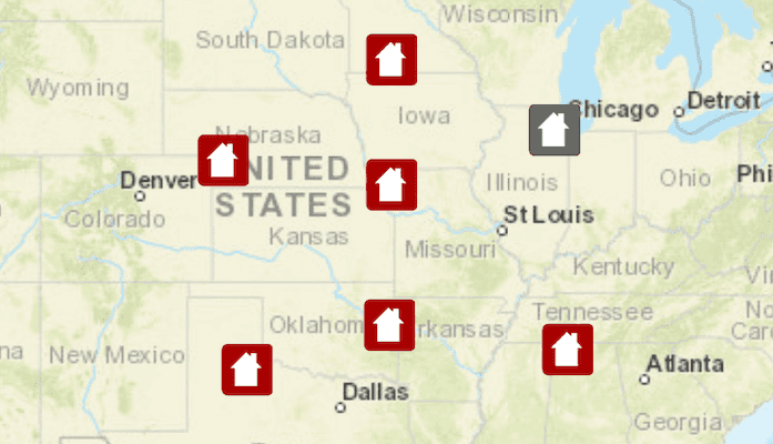
Add features to a feature layer.

Use case
An end-user performing a survey may want to add features to the map during the course of their work.
How to use the sample
Tap on a location on the map to add a feature at that location.
How it works
- Create a
ServiceFeatureTablefrom a URL. - Create a
FeatureLayerderived from theServiceFeatureTableinstance. - Create a
Featurewith attributes and a location using theServiceFeatureTable. - Add the
Featureto theServiceFeatureTable. - Apply edits to the
ServiceFeatureTablewhich will upload the new feature to the online service.
Relevant API
- Feature
- FeatureEditResult
- FeatureLayer
- ServiceFeatureTable
Tags
edit, feature, online service
Sample Code
MainActivity.java
/*
* Copyright 2019 Esri
*
* Licensed under the Apache License, Version 2.0 (the "License");
* you may not use this file except in compliance with the License.
* You may obtain a copy of the License at
*
* http://www.apache.org/licenses/LICENSE-2.0
*
* Unless required by applicable law or agreed to in writing, software
* distributed under the License is distributed on an "AS IS" BASIS,
* WITHOUT WARRANTIES OR CONDITIONS OF ANY KIND, either express or implied.
* See the License for the specific language governing permissions and
* limitations under the License.
*/
package com.esri.arcgisruntime.sample.addfeaturesfeatureservice;
import java.util.HashMap;
import java.util.List;
import java.util.Map;
import java.util.concurrent.ExecutionException;
import android.os.Bundle;
import android.util.Log;
import android.view.MotionEvent;
import android.widget.Toast;
import androidx.annotation.Nullable;
import androidx.appcompat.app.AppCompatActivity;
import com.esri.arcgisruntime.ArcGISRuntimeEnvironment;
import com.esri.arcgisruntime.concurrent.ListenableFuture;
import com.esri.arcgisruntime.data.Feature;
import com.esri.arcgisruntime.data.FeatureEditResult;
import com.esri.arcgisruntime.data.FeatureTableEditResult;
import com.esri.arcgisruntime.data.ServiceFeatureTable;
import com.esri.arcgisruntime.data.ServiceGeodatabase;
import com.esri.arcgisruntime.geometry.Point;
import com.esri.arcgisruntime.layers.FeatureLayer;
import com.esri.arcgisruntime.mapping.ArcGISMap;
import com.esri.arcgisruntime.mapping.BasemapStyle;
import com.esri.arcgisruntime.mapping.Viewpoint;
import com.esri.arcgisruntime.mapping.view.DefaultMapViewOnTouchListener;
import com.esri.arcgisruntime.mapping.view.MapView;
public class MainActivity extends AppCompatActivity {
private static final String TAG = MainActivity.class.getSimpleName();
private MapView mMapView;
private ServiceFeatureTable mServiceFeatureTable;
@Override protected void onCreate(@Nullable Bundle savedInstanceState) {
super.onCreate(savedInstanceState);
setContentView(R.layout.activity_main);
// authentication with an API key or named user is required to access basemaps and other
// location services
ArcGISRuntimeEnvironment.setApiKey(BuildConfig.API_KEY);
mMapView = findViewById(R.id.mapView);
// create a map with streets basemap
ArcGISMap map = new ArcGISMap(BasemapStyle.ARCGIS_STREETS);
// create and load the service geodatabase
ServiceGeodatabase serviceGeodatabase = new ServiceGeodatabase(getString(R.string.service_layer_url));
serviceGeodatabase.loadAsync();
serviceGeodatabase.addDoneLoadingListener(() -> {
// create a feature layer using the first layer in the ServiceFeatureTable
mServiceFeatureTable = serviceGeodatabase.getTable(0);
// create a feature layer from table
FeatureLayer featureLayer = new FeatureLayer(mServiceFeatureTable);
// add the layer to the map
map.getOperationalLayers().add(featureLayer);
// set map to be displayed in map view
mMapView.setMap(map);
mMapView.setViewpoint(new Viewpoint( 40.0, -95.0, 10000000.0));
});
// add a listener to the MapView to detect when a user has performed a single tap to add a new feature to
// the service feature table
mMapView.setOnTouchListener(new DefaultMapViewOnTouchListener(this, mMapView) {
@Override public boolean onSingleTapConfirmed(MotionEvent event) {
// create a point from where the user clicked
android.graphics.Point point = new android.graphics.Point((int) event.getX(), (int) event.getY());
// create a map point from a point
Point mapPoint = mMapView.screenToLocation(point);
// add a new feature to the service feature table
addFeature(mapPoint, mServiceFeatureTable);
return super.onSingleTapConfirmed(event);
}
});
}
/**
* Adds a new Feature to a ServiceFeatureTable and applies the changes to the
* server.
*
* @param mapPoint location to add feature
* @param featureTable service feature table to add feature
*/
private void addFeature(Point mapPoint, final ServiceFeatureTable featureTable) {
// create default attributes for the feature
Map<String, Object> attributes = new HashMap<>();
attributes.put("typdamage", "Destroyed");
attributes.put("primcause", "Earthquake");
// creates a new feature using default attributes and point
Feature feature = featureTable.createFeature(attributes, mapPoint);
// check if feature can be added to feature table
if (featureTable.canAdd()) {
// add the new feature to the feature table and to server
featureTable.addFeatureAsync(feature).addDoneListener(() -> applyEdits(featureTable));
} else {
runOnUiThread(() -> logToUser(true, getString(R.string.error_cannot_add_to_feature_table)));
}
}
/**
* Sends any edits on the ServiceFeatureTable to the server.
*
* @param featureTable service feature table
*/
private void applyEdits(ServiceFeatureTable featureTable) {
// apply the changes to the server
final ListenableFuture<List<FeatureTableEditResult>> editResult = featureTable.getServiceGeodatabase().applyEditsAsync();
editResult.addDoneListener(() -> {
try {
List<FeatureTableEditResult> editResults = editResult.get();
// check if the server edit was successful
if (editResults != null && !editResults.isEmpty()) {
runOnUiThread(() -> logToUser(false, getString(R.string.feature_added)));
}
} catch (InterruptedException | ExecutionException e) {
runOnUiThread(() -> logToUser(true, getString(R.string.error_applying_edits, e.getCause().getMessage())));
}
});
}
/**
* Shows a Toast to user and logs to logcat.
*
* @param isError whether message is an error. Determines log level.
* @param message message to display
*/
private void logToUser(boolean isError, String message) {
Toast.makeText(this, message, Toast.LENGTH_LONG).show();
if (isError) {
Log.e(TAG, message);
} else {
Log.d(TAG, message);
}
}
@Override protected void onResume() {
super.onResume();
mMapView.resume();
}
@Override protected void onPause() {
mMapView.pause();
super.onPause();
}
@Override protected void onDestroy() {
mMapView.dispose();
super.onDestroy();
}
}