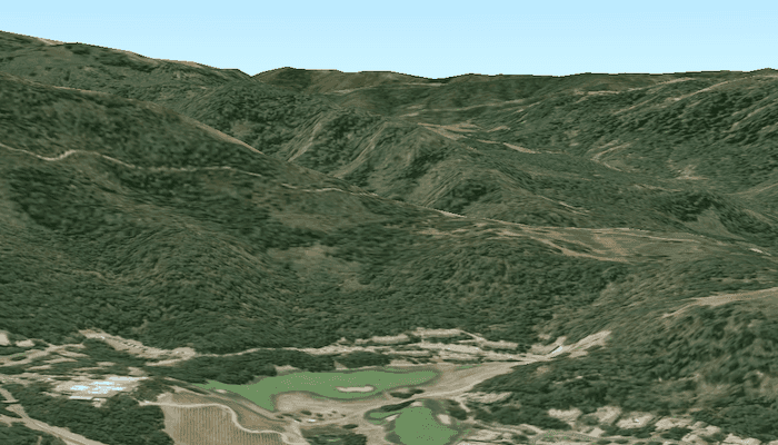
Set the terrain surface with elevation described by a local tile package.

Use case
In a scene view, the terrain surface is what the basemap, operational layers, and graphics are draped onto. For example, when viewing a scene in a mountainous region, applying a terrain surface to the scene will help in recognizing the slopes, valleys, and elevated areas.
How to use the sample
When loaded, the sample will show a scene with a terrain surface applied. Pan and zoom to explore the scene and observe how the terrain surface allows visualizing elevation differences.
How it works
- Create an
ArcGISSceneand add it to aSceneView. - Create an
ArcGISTiledElevationSourcewith the path to the local tile package. - Add this source to the scene's base surface:
ArcGISScene.getBaseSurface().getElevationSources().add(ArcGISTiledElevationSource).
Relevant API
- ArcGISTiledElevationSource
- Surface
Offline data
- Download the data from ArcGIS Online.
- Extract the contents of the downloaded zip file to disk.
- Open your command prompt and navigate to the folder where you extracted the contents of the data from step 1.
- Execute the following command:
adb push MontereyElevation.tpkx /Android/data/com.esri.arcgisruntime.sample.createterrainfromalocaltilepackage/files/MontereyElevation.tpkx
| Link | Local Location |
|---|---|
| Monterey Elevation TPKX | /Android/data/com.esri.arcgisruntime.sample.createterrainfromalocaltilepackage/files/MontereyElevation.tpk |
Additional information
The tile package must be a LERC (limited error raster compression) encoded TPKX. Details can be found in the topic Share a tile package in the ArcGIS Pro documentation.
Tags
3D, elevation, LERC, surface, terrain, tile cache
Sample Code
/*
* Copyright 2019 Esri
*
* Licensed under the Apache License, Version 2.0 (the "License");
* you may not use this file except in compliance with the License.
* You may obtain a copy of the License at
*
* http://www.apache.org/licenses/LICENSE-2.0
*
* Unless required by applicable law or agreed to in writing, software
* distributed under the License is distributed on an "AS IS" BASIS,
* WITHOUT WARRANTIES OR CONDITIONS OF ANY KIND, either express or implied.
* See the License for the specific language governing permissions and
* limitations under the License.
*/
package com.esri.arcgisruntime.samples.createterrainfromalocaltilepackage;
import android.os.Bundle;
import android.util.Log;
import android.widget.Toast;
import androidx.annotation.Nullable;
import androidx.appcompat.app.AppCompatActivity;
import com.esri.arcgisruntime.ArcGISRuntimeEnvironment;
import com.esri.arcgisruntime.loadable.LoadStatus;
import com.esri.arcgisruntime.mapping.ArcGISScene;
import com.esri.arcgisruntime.mapping.ArcGISTiledElevationSource;
import com.esri.arcgisruntime.mapping.Basemap;
import com.esri.arcgisruntime.mapping.BasemapStyle;
import com.esri.arcgisruntime.mapping.view.Camera;
import com.esri.arcgisruntime.mapping.view.SceneView;
public class MainActivity extends AppCompatActivity {
private static final String TAG = MainActivity.class.getSimpleName();
private SceneView mSceneView;
@Override protected void onCreate(@Nullable Bundle savedInstanceState) {
super.onCreate(savedInstanceState);
setContentView(R.layout.activity_main);
// authentication with an API key or named user is required to access basemaps and other
// location services
ArcGISRuntimeEnvironment.setApiKey(BuildConfig.API_KEY);
mSceneView = findViewById(R.id.sceneView);
// create a scene and add a basemap to it
ArcGISScene scene = new ArcGISScene(BasemapStyle.ARCGIS_IMAGERY);
// add the scene to the sceneview
mSceneView.setScene(scene);
// specify the initial camera position
Camera camera = new Camera(36.525, -121.80, 300.0, 180, 80.0, 0.0);
mSceneView.setViewpointCamera(camera);
// add a ArcGISTiledElevationSource to the scene by passing the URI of the local tile package to the constructor
ArcGISTiledElevationSource tiledElevationSource = new ArcGISTiledElevationSource(
getExternalFilesDir(null) + getString(R.string.local_tile_package_location));
// add a listener to perform operations when the load status of the ArcGISTiledElevationSource changes
tiledElevationSource.addLoadStatusChangedListener(loadStatusChangedEvent -> {
// when ArcGISTiledElevationSource loads
if (loadStatusChangedEvent.getNewLoadStatus() == LoadStatus.LOADED) {
// add the ArcGISTiledElevationSource to the elevation sources of the scene
mSceneView.getScene().getBaseSurface().getElevationSources().add(tiledElevationSource);
} else if (loadStatusChangedEvent.getNewLoadStatus() == LoadStatus.FAILED_TO_LOAD) {
// notify user that the ArcGISTiledElevationSource has failed to load
logErrorToUser(getString(R.string.error_tiled_elevation_source_load_failure_message));
}
});
// load the ArcGISTiledElevationSource asynchronously
tiledElevationSource.loadAsync();
}
private void logErrorToUser(String message) {
Toast.makeText(this, message, Toast.LENGTH_LONG).show();
Log.e(TAG, message);
}
}