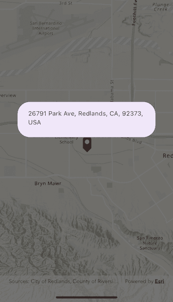
Use an online service to find the address for a tapped point.

Use case
You might use a geocoder to find a customer's delivery address based on the location returned by their device's GPS.
How to use the sample
Tap the map to see the nearest address displayed in a callout.
How it works
- Create a
LocatorTaskobject using a URL to a geocoder service. - Set the
ReverseGeocodeParametersfor theLocatorTaskand specify the geocoder's attributes. - Get the matching results from the
ReverseGeocodeResultusingLocatorTask.reverseGeocode. - Show the results using a
PictureMarkerSymboland add the symbol to aGraphicin theGraphicsOverlay.
Relevant API
- GeocodeParameters
- LocatorTask
- ReverseGeocodeParameters
Additional information
This sample uses the World Geocoding Service. For more information, see the Geocoding service help topic on the ArcGIS Developer website.
Tags
address, geocode, locate, reverse geocode, search
Sample Code
find_address_with_reverse_geocode.dart
//
// Copyright 2024 Esri
//
// Licensed under the Apache License, Version 2.0 (the "License");
// you may not use this file except in compliance with the License.
// You may obtain a copy of the License at
//
// https://www.apache.org/licenses/LICENSE-2.0
//
// Unless required by applicable law or agreed to in writing, software
// distributed under the License is distributed on an "AS IS" BASIS,
// WITHOUT WARRANTIES OR CONDITIONS OF ANY KIND, either express or implied.
// See the License for the specific language governing permissions and
// limitations under the License.
//
import 'package:arcgis_maps/arcgis_maps.dart';
import 'package:flutter/material.dart';
import '../../utils/sample_state_support.dart';
class FindAddressWithReverseGeocode extends StatefulWidget {
const FindAddressWithReverseGeocode({super.key});
@override
State<FindAddressWithReverseGeocode> createState() =>
_FindAddressWithReverseGeocodeState();
}
class _FindAddressWithReverseGeocodeState
extends State<FindAddressWithReverseGeocode> with SampleStateSupport {
final _graphicsOverlay = GraphicsOverlay();
final _worldLocatorTask = LocatorTask.withUri(
Uri.parse(
'https://geocode-api.arcgis.com/arcgis/rest/services/World/GeocodeServer',
),
);
// Create a controller for the map view.
final _mapViewController = ArcGISMapView.createController();
final _initialViewpoint = Viewpoint.fromCenter(
ArcGISPoint(
x: -117.195,
y: 34.058,
spatialReference: SpatialReference.wgs84,
),
scale: 5e4,
);
// A flag for when the map view is ready and controls can be used.
var _ready = false;
@override
Widget build(BuildContext context) {
return Scaffold(
body: Stack(
children: [
// Add a map view to the widget tree and set a controller.
ArcGISMapView(
controllerProvider: () => _mapViewController,
onMapViewReady: onMapViewReady,
onTap: onTap,
),
// Display a progress indicator and prevent interaction until state is ready.
Visibility(
visible: !_ready,
child: SizedBox.expand(
child: Container(
color: Colors.white30,
child: const Center(child: CircularProgressIndicator()),
),
),
),
],
),
);
}
void onMapViewReady() async {
// Create a map with the topographic basemap style and set to the map view.
final map = ArcGISMap.withBasemapStyle(BasemapStyle.arcGISTopographic);
_mapViewController.arcGISMap = map;
// Zoom to a specific extent.
_mapViewController.setViewpoint(_initialViewpoint);
// Create a picture marker symbol using an image asset.
final image = await ArcGISImage.fromAsset('assets/pin_circle_red.png');
final pictureMarkerSymbol = PictureMarkerSymbol.withImage(image)
..width = 35
..height = 35;
pictureMarkerSymbol.offsetY = pictureMarkerSymbol.height / 2;
// Create a renderer using the picture marker symbol and set to the graphics overlay.
_graphicsOverlay.renderer = SimpleRenderer(symbol: pictureMarkerSymbol);
// Add the graphics overlay to the map view.
_mapViewController.graphicsOverlays.add(_graphicsOverlay);
// Load the locator task and once loaded set the _ready flag to true to enable the UI.
await _worldLocatorTask.load();
setState(() => _ready = true);
}
void onTap(Offset localPosition) async {
// Remove already existing graphics.
if (_graphicsOverlay.graphics.isNotEmpty) _graphicsOverlay.graphics.clear();
// Convert the screen point to a map point.
final mapTapPoint =
_mapViewController.screenToLocation(screen: localPosition);
if (mapTapPoint == null) return;
// Normalize the point incase the tapped location crosses the international date line.
final normalizedTapPoint =
GeometryEngine.normalizeCentralMeridian(mapTapPoint);
if (normalizedTapPoint == null) return;
// Create a graphic object for the tapped point.
_graphicsOverlay.graphics.add(Graphic(geometry: normalizedTapPoint));
// Initialize reverse geocode parameters.
final reverseGeocodeParameters = ReverseGeocodeParameters()..maxResults = 1;
// Perform a reverse geocode using the tapped location and parameters.
final reverseGeocodeResult = await _worldLocatorTask.reverseGeocode(
location: normalizedTapPoint as ArcGISPoint,
parameters: reverseGeocodeParameters,
);
if (reverseGeocodeResult.isEmpty) return;
// Get attributes from the first result and display a formatted address in a dialog.
final firstResult = reverseGeocodeResult.first;
final cityString = firstResult.attributes['City'] ?? '';
final addressString = firstResult.attributes['Address'] ?? '';
final stateString = firstResult.attributes['RegionAbbr'] ?? '';
final resultStrings = [addressString, cityString, stateString];
final combinedString =
resultStrings.where((str) => str.isNotEmpty).join(', ');
if (mounted) {
showDialog(
context: context,
builder: (BuildContext context) {
return AlertDialog(content: Text(combinedString));
},
);
}
}
}