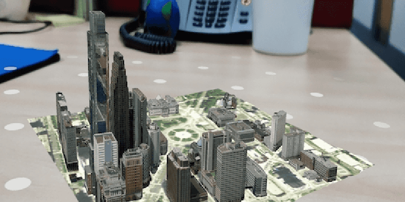
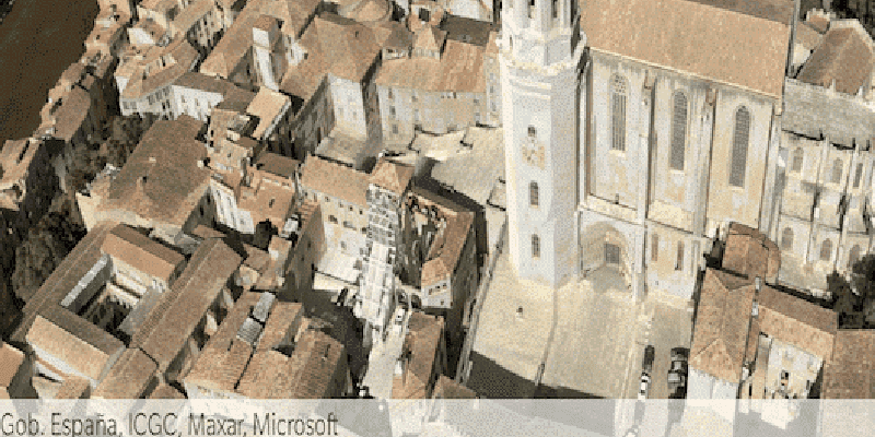
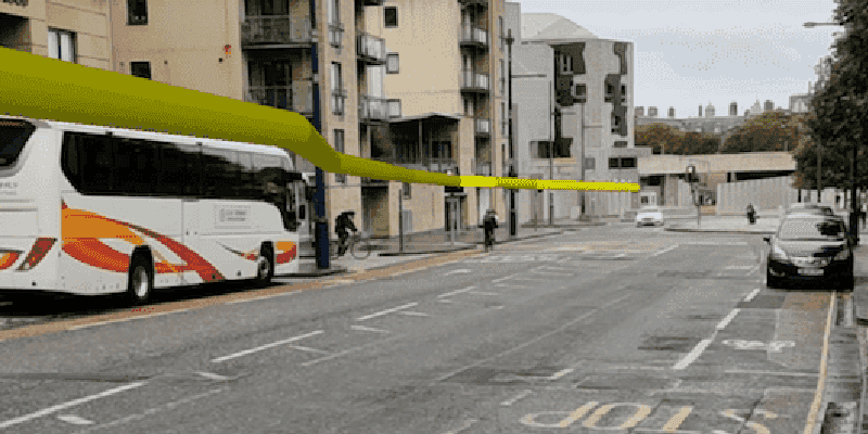
Augmented reality (AR) experiences can be implemented with three common patterns: tabletop, flyover, and world-scale.
- Flyover – With flyover AR you can explore a scene using your device as a window into the virtual world. A typical flyover AR scenario starts with the scene’s virtual camera positioned over an area of interest. You can walk around and reorient the device to focus on specific content in the scene.
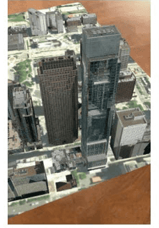
- Tabletop – Tabletop AR provides scene content anchored to a physical surface, as if it were a 3D-printed model. You can walk around the tabletop and view the scene from different angles.
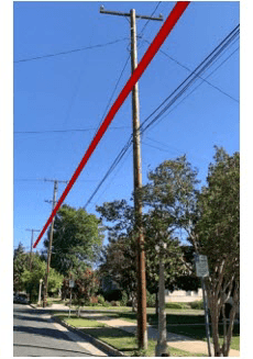
- World-scale – A kind of AR scenario where scene content is rendered exactly where it would be in the physical world. This is used in scenarios ranging from viewing hidden infrastructure to displaying waypoints for navigation. In AR, the real world, rather than a basemap, provides the context for your GIS data.
| Flyover | Tabletop | World-scale |
|---|---|---|
|
|
|
| On screen, flyover is visually indistinguishable from normal scene rendering. | In tabletop, scene content is anchored to a real-world surface. | In world-scale AR, scene content is integrated with the real world. |
Support for augmented reality is provided through tools available in each ArcGIS Runtime API Toolkit.
Enable your app for AR
- See the Toolkit repo on GitHub for the latest instructions for installing.
- Add an AR view to your app.
- Configure privacy and permissions.
- Now you're ready to add tabletop AR, add flyover AR, or add world-scale AR to your app.
Add an AR view to your app
ArcGISAR uses an underlying ARKit or ARCore view and an ArcGIS Runtime
AGSSceneView
. Use the scene method to access the Runtime scene view.
Use the following methods on ArcGISAR to configure AR:
translation- controls the relationship between physical device position changes and changes in the position of the scene view's camera. This is useful for tabletop and flyover AR.Factor origin- controls the initial position of the scene view's camera. When position tracking is started,Camera ArcGISARtransforms the scene view camera's position using a transformation matrix provided by ARKit or ARCore. Once the origin camera is set, the manipulation of the scene view's camera is handled automatically.View set– takes a point on the screen, finds the surface represented by that point, and applies a transformation such that the origin camera is pinned to the location represented by that point. This is useful for pinning content to a surface, which is needed for tabletop AR.Initial Transformation ar– forwards messages from ARKit to your app. You can use this to listen for tracking status changes, render content using native iOS rendering (SceneKit).SCN View Delegate location- forwards messages from the location data source associated with the ArcGISARView to your app. You can use this to listen for location, heading and status changes.Change Handler Delegate
In addition to the toolkit, you'll need to use the following ArcGIS Runtime features provided by the underlying scene view when creating AR experiences:
- Scene view space effect control — Disable rendering the 'starry sky' effect to display scene content on top of a camera feed.
- Scene view atmosphere effect control — Disable rendering the atmosphere effect to avoid obscuring rendered content.
- Surface transparency — Hide the ground when rendering world-scale AR because the camera feed, not the basemap, is providing context for your GIS content. You can use a semitransparent surface to calibrate your position in world-scale AR.
- Scene view navigation constraint — By default, scene views constrain the camera to being above the ground. You should disable this feature to enable users to use world-scale AR underground (for example, while in a basement). The navigation constraint will interfere with tabletop AR if the user attempts to look at the scene from below.
To use ArcGISAR, first add it to the view, then configure the lifecycle methods to start and stop tracking as needed.
import UIKit
import ARKit
import ArcGISToolkit
import ArcGIS
class BasicARExample: UIViewController {
private let arView = ArcGISARView()
override func viewDidLoad() {
super.viewDidLoad()
arView.translatesAutoresizingMaskIntoConstraints = false
view.addSubview(arView)
NSLayoutConstraint.activate([
arView.leadingAnchor.constraint(equalTo: view.leadingAnchor),
arView.trailingAnchor.constraint(equalTo: view.trailingAnchor),
arView.topAnchor.constraint(equalTo: view.topAnchor),
arView.bottomAnchor.constraint(equalTo: view.bottomAnchor)
])
}
override func viewDidAppear(_ animated: Bool) {
super.viewDidAppear(animated)
arView.startTracking(.ignore)
}
override func viewDidDisappear(_ animated: Bool) {
super.viewDidDisappear(animated)
arView.stopTracking()
}
}
Configure privacy and permissions
Before you can use augmented reality, you'll need to request location and camera permissions.
On iOS, ensure the following properties are set in info.plist:
Privacy - Camera Usage DescriptionPrivacy - Location When In Use Usage Description
The deployment target should be set to a supported version of iOS (see System requirements for details).
If you’d like to restrict your app to installing only on devices that support ARKit, add arkit to the required device capabilities section of info.plist:
<key>UIRequiredDeviceCapabilities</key>
<array>
<string>arkit</string>
</array>Once you have installed the toolkit, configured your app to meet privacy requirements, requested location permissions, and added an ArcGISAR to your app, you can begin implementing your AR experience.
Understand Common AR Patterns
There are many AR scenarios you can achieve with Runtime. This SDK recognizes the following common patterns for AR:
- Flyover – Flyover AR is a kind of AR scenario that allows you to explore a scene using your device as a window into the virtual world. A typical flyover AR scenario will start with the scene’s virtual camera positioned over an area of interest. You can walk around and reorient the device to focus on specific content in the scene.
- Tabletop – A kind of AR scenario where scene content is anchored to a physical surface, as if it were a 3D-printed model. You can walk around the tabletop and view the scene from different angles.
- World-scale – A kind of AR scenario where scene content is rendered exactly where it would be in the physical world. This is used in scenarios ranging from viewing hidden infrastructure to displaying waypoints for navigation. In AR, the real world, rather than a basemap, provides the context for your GIS data.
Each experience is built using some combination of the features in Runtime and the toolkit and some basic behavioral assumptions.
| AR pattern | Origin camera | Translation factor | Scene view | Base surface |
|---|---|---|---|---|
| Flyover AR | Above the tallest content in the scene | A large value to enable rapid traversal; 0 to restrict movement | Space effect: Stars Atmosphere: Realistic | Displayed |
| Tabletop AR | On the ground at the center or lowest point on the scene | Based on the size of the target content and the physical table | Space effect: Transparent Atmosphere: None | Optional |
| World-scale AR | At the same location as the physical device camera | 1, to keep virtual content in sync with real-world environment | Space effect: Transparent Atmosphere: None | Optional for calibration |
Add tabletop AR to your app
Tabletop AR allows you to use your device to interact with scenes as if they were 3D-printed models sitting on your desk. You could, for example, use tabletop AR to virtually explore a proposed development without needing to create a physical model.
Implement tabletop AR
Tabletop AR often allows users to place scene content on a physical surface of their choice, such as the top of a desk, for example. Once the content is placed, it stays anchored to the surface as the user moves around it.
-
Create an
ArcGISARand add it to the viewView -
Listen for ARKit tracking tracking status changes and provide feedback to the user, for example when the user needs to move the phone more slowly or turn on more lights.
Use dark colors for code blocks Copy override viewDidLoad() { // the rest of viewDidLoad // Configure the ArcGISARView’s arSCNViewDelegate to receive status updates arView.arSCNViewDelegate = self } extension BasicARExample: ARSCNViewDelegate { public func session(_ session: ARSession, cameraDidChangeTrackingState camera: ARCamera) { switch camera.trackingState { case .normal: helpLabel.isHidden = true case .notAvailable: helpLabel.text = "Location not available" case .limited(let reason): switch reason { case .excessiveMotion: helpLabel.text = "Try moving your phone more slowly" helpLabel.isHidden = false case .initializing: helpLabel.text = "Keep moving your phone" helpLabel.isHidden = false case .insufficientFeatures: helpLabel.text = "Try turning on more lights and moving around" helpLabel.isHidden = false case .relocalizing: // this won't happen unless you enable relocalization break @unknown default: break } } } } -
When tracking is ready and at least one plane has been found, wait for the user to tap.
ARSCNdefinesView Delegate renderer(which you can use to detect planes.:did Add node, for anchor) Use dark colors for code blocks Copy extension BasicARExample: ARSCNViewDelegate { //… public func renderer(_ renderer: SCNSceneRenderer, didAdd node: SCNNode, for anchor: ARAnchor) { // Only proceed if a plane node was detected guard anchor as? ARPlaneAnchor != nil else { return } // hasFoundPlane is an instance variable on BasicARExample if !hasFoundPlane { hasFoundPlane = true enableTapToPlace() } }} extension BasicARExample: AGSGeoViewTouchDelegate { public func geoView(_ geoView: AGSGeoView, didTapAtScreenPoint screenPoint: CGPoint, mapPoint: AGSPoint) { // TODO – implement map placement } private func enableTapToPlace() { DispatchQueue.main.async { [weak self] in guard let self = self else { return } // Wait for the user to tap to place the scene self.arView.sceneView.touchDelegate = self } } } -
Once the user has tapped a point, call
set. The toolkit will use the native platform’s plane detection to position the virtual camera relative to the plane. If the result is true, the transformation has been set successfully and you can place the scene.Initial Transformation Use dark colors for code blocks Copy extension BasicARExample: AGSGeoViewTouchDelegate { public func geoView(_ geoView: AGSGeoView, didTapAtScreenPoint screenPoint: CGPoint, mapPoint: AGSPoint) { // Use a screen point to set the initial transformation on the view. if self.arView.setInitialTransformation(using: screenPoint) { configureSceneForAR() } else { presentAlert(message: "Failed to place scene, try again") } } private func enableTapToPlace() { DispatchQueue.main.async { [weak self] in guard let self = self else { return } self.helpLabel.isHidden = false self.helpLabel.text = "Tap a surface to place the scene" // Wait for the user to tap to place the scene self.arView.sceneView.touchDelegate = self } } } -
Create and display the scene. Set the navigation constraint on the scene’s base surface to
.none.For demonstration purposes, this code uses the Philadelphia mobile scene package because it is particularly well-suited for tabletop display. You can download that .mspk and add it to your project to make the code below work. Alternatively, you can use any scene for tabletop mapping, but be sure to define a clipping distance for a proper tabletop experience.
Use dark colors for code blocks Copy let package = AGSMobileScenePackage(name: "philadelphia") private func configureSceneForAR() { // Load the package package.load { [weak self] (err: Error?) in guard let self = self else { return } if let error = err { self.presentAlert(error: error) } else if let scene = self.package.scenes.first { // Display the scene self.arView.sceneView.scene = scene // Configure scene surface opacity and navigation constraint if let surface = scene.baseSurface { surface.opacity = 0 surface.navigationConstraint = .none } self.updateTranslationFactorAndOriginCamera(scene) // To do } } } -
Find an anchor point in the scene. You can use a known value, a user-selected value, or a computed value. For simplicity, this example uses a known value. Place the origin camera at that point.
Use dark colors for code blocks Copy private func updateTranslationFactorAndOriginCamera() { // Create the origin camera to be at the bottom and in the center of the scene let newCam = AGSCamera(latitude: 39.95787000283599, longitude: -75.16996728256345, altitude: 8.813445091247559, heading: 0, pitch: 90, roll: 0) // Set the origin camera self.arView.originCamera = newCam } -
Set the translation factor on the ArcGIS AR view so that the whole scene can be viewed by moving around it. A useful formula for determining this value is translation factor = virtual content width / desired physical content width. The desired physical content width is the size of the physical table while virtual content width is the real-world size of the scene content; both measurements should be in meters. You can set the virtual content width by setting a clipping distance.
Use dark colors for code blocks Copy private func updateTranslationFactorAndOriginCamera() { // Continued from above... // Scene width is about 800m let geographicContentWidth = 800.0 // Physical width of the table area the scene will be placed on in meters let tableContainerWidth = 0.5 // About 1.5 feet // Set the translation factor based on scene content width and desired physical size self.arView.translationFactor = geographicContentWidth / tableContainerWidth // Set the origin camera self.arView.originCamera = newCam }
Guidelines for tabletop AR user experience
To create an optimal tabletop mapping experience:
- Provide user feedback for ARKit tracking issues. See Apple's Human Interface Guidelines for details.
- Set expectations about lighting before starting the experience. AR doesn't work well in low light.
- Don't allow users to view arbitrary content in AR. Use curated content that has been designed.
- Keep scene content focused; this should ideally be a single geographic feature or a small area of a city.
- Ensure that the scene looks good from below; your users may attempt to look at the scene from any angle.
- When using scenes that aren’t confined to a small area, set a clipping distance to ensure that content is limited to a small area on the physical surface.
Add flyover AR to your app
Flyover AR displays a scene while using the movement of the physical device to move the scene view camera. For example, you can walk around while holding up your device as a window into the scene. Unlike other AR experiences, the camera feed is not displayed to the user, making flyover more similar to a traditional virtual reality (VR) experience.
Flyover is the simplest AR scenario to implement, as there is only a loose relationship between the physical world and the rendered virtual world. With flyover, you can imagine your device as a window into the virtual scene.
Implement flyover AR
-
Create the AR view and add it to the UI.
-
Create the scene, add any content, then display it. This example uses an integrated mesh layer.
Use dark colors for code blocks Copy private func configureSceneForAR() { // create scene with basemap let scene = AGSScene(basemapStyle: .arcGISImagery) // create and add mesh layer let meshLayer = AGSIntegratedMeshLayer(url: URL(string: "https://tiles.arcgis.com/tiles/u0sSNqDXr7puKJrF/arcgis/rest/services/Frankfurt2017_v17/SceneServer/layers/0")!) scene.operationalLayers.add(meshLayer) // show scene arView.sceneView.scene = scene // TODO – configure origin camera for AR } -
Place the origin camera above the content you want the user to explore, ideally in the center. Typically, you’ll want to place the origin camera above the highest point in your scene.
Use dark colors for code blocks Copy private func configureSceneForAR() { // Continued from above // Wait for the layer to load, then set the AR camera meshLayer.load { [weak self, weak meshLayer] (err: Error?) in guard let self = self else { return } guard let `meshLayer` = meshLayer else { return } if let error = err { self.presentAlert(error: error) } else if let envelope = meshLayer.fullExtent { let camera = AGSCamera(latitude: envelope.center.y, longitude: envelope.center.x, altitude: 600, heading: 0, pitch: 90, roll: 0) self.arView.originCamera = camera } } } -
Set the translation factor to allow rapid traversal of the scene. The translation factor defines the relationship between physical device movement and virtual camera movement. To create a more immersive experience, set the space effect on the scene view to
.starsand the atmosphere effect to.realistic. Disable the navigation constraint on the scene's base surface to prevent camera position problems near the ground.Use dark colors for code blocks Copy private func configureAR() { // Continued from above // Set the translation factor to enable rapid movement through the scene arView.translationFactor = 1000 // Disable the navigation constraint scene.baseSurface?.navigationConstraint = .none // Turn the space and atmosphere effects on for an immersive experience arView.sceneView.spaceEffect = .stars arView.sceneView.atmosphereEffect = .realistic }
Guidelines for flyover AR
Consider the following guidelines for creating high-quality flyover AR experiences:
- Provide actionable feedback to the user when there are ARKit tracking issues. Tracking problems caused by environmental factors like low light can break the AR experience.
- Set expectations about the environment before starting the AR experience. Flyover AR doesn't work well in low light or in tight, constrained spaces.
- Start the AR experience in the center of the area of interest for your scene. Users are likely to move around freely, including rotating and looking behind where they originally start.
Add world-scale AR to your app
A world-scale AR experience is defined by the following characteristics:
- The scene camera is positioned to precisely match the position and orientation of the device’s physical camera
- Scene content is placed in the context of the real world by matching the scene view’s virtual camera position and orientation to that of the physical device camera.
- Context aids, like the basemap, are hidden; the camera feed provides real-world context.
Some example use cases of world-scale AR include:
- Visualizing hidden infrastructure, like sewers, water mains, and telecom conduits.
- Maintaining context while performing rapid data collection for a survey.
- Visualizing a route line while navigating.
Configure content for world-scale AR
The goal of a world-scale AR experience is to create the illusion that your GIS content is physically present in the world around you. There are several requirements for content that will be used for world-scale AR that go beyond what is typically required for 2D mapping.
- Ensure that all data has an accurate elevation (or Z) value. For dynamically generated graphics (for example, route results) use an elevation surface to add elevation.
- Use an elevation source in your scene to ensure all content is placed accurately relative to the user.
- Don't use 3D symbology that closely matches the exact shape of the feature it represents. For example, do not use a generic tree model to represent tree features or a fire hydrant to represent fire hydrant features. Generic symbology won’t capture the unique geometry of actual real-world objects and will highlight minor inaccuracies in position.
- Consider how you present content that would otherwise be obscured in the real world, as the parallax effect can make that content appear to move unnaturally. For example, underground pipes will ‘float’ relative to the surface, even though they are at a fixed point underground. Have a plan to educate users, or consider adding visual guides, like lines drawn to link the hidden feature to the obscuring surface (for example, the ground).
- By default, ArcGIS Runtime renders content over a large distance, which can be problematic when you are trying to view a limited subset of nearby features (just the pipes in your building, not for the entire campus, for example). You can use the clipping distance to limit the area over which scene content renders.
Location tracking options for world-scale AR
There are a few strategies for determining the device’s position in the world and maintaining that position over time:
- Use the device’s location data source (for example, GPS) to acquire an initial position and make further position updates using ARKit and ARCore only.
- Use the location data source continuously.
With continuous updates, the origin camera is set every time the location data source provides a new update. With a one-time update, the origin camera is set only once.
There are benefits and drawbacks to each approach that you should consider when designing your AR experience:
- One-time update
- Advantage: ARKit/ARCore tracking is more precise than most location data sources.
- Advantage: Content stays convincingly pinned to its real-world position, with minimal drifting or jumping.
- Disadvantage: Error accumulates the further you venture from where you start the experience.
- Continuous update
- Advantage: Works over a larger area than ARKit or ARCore.
- Disadvantage: Visualized content will jump as you move through the world and the device’s location is updated (as infrequently as once per second rather than ARKit’s 60 times per second).
- Disadvantage: Because the origin camera is constantly being reset, you can’t use panning to manually correct position errors.
You don’t need to make a binary choice between approaches for your app. Your app can use continuous updates while the user moves through larger areas, then switch to a primarily ARKit or ARCore-driven experience when you need greater precision.
Using ArcGIS Runtime, the choice of location strategy is specified with a call to start on the AR view control. To change the location update mode, stop tracking and then resume tracking with the desired mode.
Implement world-scale AR
-
Create an
ArcGISARand add it to the view.View -
Configure the
ArcGISARwith a location data source. The location data source provides location information for the device. The AR scene view uses the location data source to place the virtual scene camera close to the location of the physical device’s camera.View Use dark colors for code blocks Copy arView.locationDataSource = AGSCLLocationDataSource() -
Configure the scene for AR by setting the space and atmosphere effects and adding an elevation source, then display it.
Use dark colors for code blocks Copy private func configureSceneForAR() { // Create scene with imagery basemap let scene = AGSScene(basemapStyle: .arcGISImagery) // Create an elevation source and add it to the scene let elevationSource = AGSArcGISTiledElevationSource(url: URL(string: "https://elevation3d.arcgis.com/arcgis/rest/services/WorldElevation3D/Terrain3D/ImageServer")!) scene.baseSurface?.elevationSources.append(elevationSource) // Allow camera to go beneath the surface scene.baseSurface?.navigationConstraint = .none // Display the scene arView.sceneView.scene = scene // Configure atmosphere and space effect arView.sceneView.spaceEffect = .transparent arView.sceneView.atmosphereEffect = .none } -
Start tracking using one of two Location tracking options for world-scale AR, continuous or once only.
Use dark colors for code blocks Copy override func viewDidAppear(_ animated: Bool) { super.viewDidAppear(animated) // Continuous update mode arView.startTracking(.continuous, completion: nil) // One-time update mode // arView.startTracking(.initial, completion: nil) } -
Provide a calibration UI to allow your users to correct heading, elevation, and location errors.
See Enable calibration for world-scale AR for more details.
Enable calibration for world-scale AR
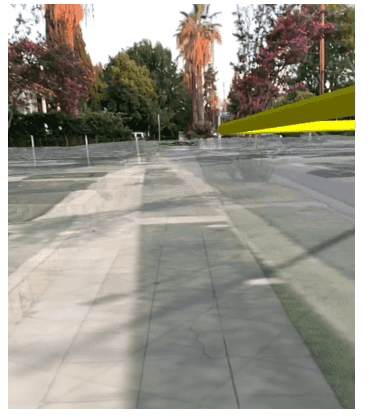
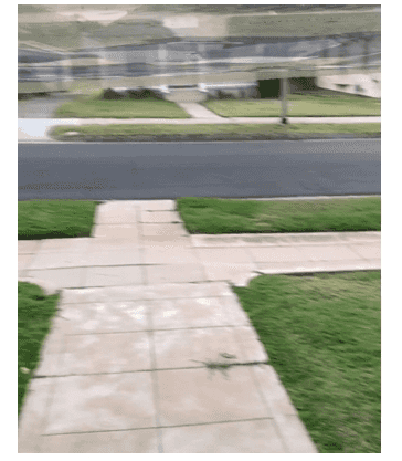
World-scale AR depends on a close match between the positions and orientations of the device’s physical camera and the scene view’s virtual camera. Any error in the device’s position or orientation will degrade the experience. Consider each of the following key properties as common sources of error:
- Heading – Usually determined using a magnetometer (compass) on the device
- Elevation/Altitude (Z) – Usually determined using GPS/GNSS or a barometer
- Position (X,Y) – usually determined using GPS/GNSS, cell triangulation, or beacons
The following examples illustrate these errors by showing a semitransparent basemap for comparison with the ground truth provided by the camera:
| Orientation error | Elevation error | Position error |
|---|---|---|
|
|
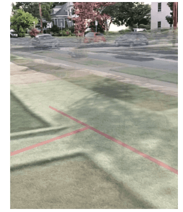
|
Design a calibration workflow
There are many ways to calibrate position and heading. In most scenarios, you’ll need to provide one or more points of comparison between scene content and the real-world ground truth. Consider the following options for allowing the user to visually calibrate the position:
- Align the imagery on the basemap with the camera feed.
- Align a known calibration feature with its real-world equivalent (for example, a previously recorded tree feature).
- Define a start point and heading and direct the user.
Consider the following UI options for allowing the user to adjust the calibration:
- Display sliders for orientation and elevation adjustment.
- Use 'joystick' sliders, where the further from the center the slider moves, the faster the adjustment goes.
- Use an image placed in a known position in conjunction with ARCore/ARKit image detection to automatically determine the device's position.
Explicitly plan for calibration when designing your AR experiences. Consider how and where your users will use your app. Not all calibration workflows are appropriate for all locations or use cases.
Identify real-world and in-scene objects
ArcGIS Runtime scene views have two methods for determining the location in a scene that corresponds to a point on the device's screen:
screen(to– ignores non-surface content, like 3D buildingsBase Surface : ) screen(to– includes non-surface contentLocation :, completion :)
ArcGISAR has ar, which:
- Performs a hit test using ARKit to find a real-world plane.
- Applies a transformation to determine the physical position of that plane relative to the known position of the device's camera.
- Returns the real-world position of the tapped plane.
You can use ar to enable field data collection workflows where users tap to identify real-world objects in the camera feed as detected by ARKit. The position of the tapped object will be more accurate than using the device's location, as you might with a typical field data collection process.
Manage vertical space in world-scale AR
Accurate positioning is particularly important to world-scale AR; even small errors can break the perception that the virtual content is anchored in the real world. Unlike 2D mapping, Z values are important. And unlike traditional 3D experiences, you need to know the position of the user’s device.
Be aware of the following common Z-value challenges that you’re likely to encounter while building AR experiences:
- Many kinds of Z values – Android and iOS devices differ in how they represent altitude/elevation/Z values.
- Imprecise altitude – Altitude/Elevation is the least precise measurement offered by GPS/GNSS. In testing, we found devices reported elevations that were anywhere between 10 and 100 above or below the true value, even under ideal conditions.
Many kinds of Z values
Just as there are many ways to represent position using X and Y values, there are many ways to represent Z values. GPS devices tend to use two primary reference systems for altitude/elevation:
- WGS84 – Height Above Ellipsoid (HAE)
- Orthometric – Height Above Mean Sea Level (MSL)
The full depth of the differences between these two references is beyond the scope of this topic, but do keep in mind the following facts:
- Android devices return elevations in HAE, while iOS devices return altitude in MSL.
- It is not trivial to convert between HAE and MSL; MSL is based on a measurement of the Earth’s gravitational field. There are many models, and you may not know which model was used to when generating data.
- Esri’s world elevation service uses orthometric altitudes.
- The difference between MSL and HAE varies by location and can be on the order of tens of meters. For example, at Esri’s HQ in Redlands, California, the MSL altitude is about 30 meters higher than the HAE elevation.
It is important that you understand how your Z values are defined to ensure that data is placed correctly in the scene. For example, the Esri world elevation service uses MSL for its Z values. If you set the origin camera using an HAE Z value, you could be tens of meters off from the desired location.
To gain a deeper understanding of these issues, see ArcUser: Mean Sea Level, GPS, and the Geoid.
Visualize planes and features detected by ARKit
Some workflows, like tapping to place a tabletop scene or collecting a feature, rely on ARKit features that detect planes. Plane visualization is particularly useful for two common scenarios:
- Visualization provides feedback to users, so they know which surfaces the app has detected and can interact with
- Visualization is useful while developing and testing your app. ARKit can be configured to render planes.
override func viewDidLoad() {
//…
arView.arSCNViewDelegate = self
/…
}
extension ARExample: ARSCNViewDelegate {
let planeRenderingMaterial = SCNMaterial()
public init() {
planeRenderingMaterial.diffuse.contentColor = UIColor(1, 0.5f)
}
public func renderer(_ renderer: SCNSceneRenderer, didAdd node: SCNNode, for anchor: ARAnchor) {
if shouldHidePlanes {
return
}
guard let _ = anchor as? ARPlaneAnchor else { return }
// Create a custom object to visualize the plane geometry and extent.
if #available(iOS 11.3, *) {
// Place content only for anchors found by plane detection.
guard let planeAnchor = anchor as? ARPlaneAnchor else { return }
let arGeometry = planeAnchor.geometry
let arPlaneSceneGeometry = ARSCNPlaneGeometry(device: renderer.device!)
arPlaneSceneGeometry?.update(from: arGeometry)
let newNode = SCNNode(geometry: arPlaneSceneGeometry)
node.addChildNode(newNode)
arPlaneSceneGeometry?.materials = [_planeRenderingMaterial]
node.geometry = arPlaneSceneGeometry
}
}
public func renderer(_ renderer: SCNSceneRenderer, didUpdate node: SCNNode, for anchor: ARAnchor) {
if shouldHidePlanes {
// Remove plane visualization
node.removeFromParentNode()
return
}
// Create a custom object to visualize the plane geometry and extent.
if #available(iOS 11.3, *) {
// Place content only for anchors found by plane detection.
guard let planeAnchor = anchor as? ARPlaneAnchor else { return }
let arGeometry = planeAnchor.geometry
let arPlaneSceneGeometry = ARSCNPlaneGeometry(device: renderer.device?)
arPlaneSceneGeometry?.update(from: arGeometry)
node.childNodes[0].geometry = arPlaneSceneGeometry
if let material = node.geometry?.materials {
arPlaneSceneGeometry?.materials = material
}
}
}
}