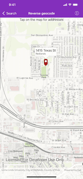
Use an online service to find the address for a tapped point.

Use case
You might use a geocoder to find a customer's delivery address based on the location returned by their device's GPS.
How to use the sample
Tap the map to see the nearest address displayed in a callout.
How it works
- Create an
AGSLocatorTaskobject using a URL to a geocoder service. - Create an instance of
AGSReverseGeocodeParametersand setAGSReverseGeocodeParameters.maxResultsto 1. - Pass
AGSReverseGeocodeParametersintoAGSLocatorTask.reverseGeocode(withLocation:parameters:completion:)and get the matching results from theAGSGeocodeResult. - Show the results using an
AGSPictureMarkerSymboland add the symbol to anAGSGraphicin theAGSGraphicsOverlay.
Relevant API
- AGSGeocodeParameters
- AGSLocatorTask
- AGSReverseGeocodeParameters
Additional information
This sample uses the World Geocoding Service. For more information, see Geocoding service from ArcGIS for Developers.
Tags
address, geocode, locate, reverse geocode, search
Sample Code
ReverseGeocodeViewController.swift
// Copyright 2016 Esri.
//
// Licensed under the Apache License, Version 2.0 (the "License");
// you may not use this file except in compliance with the License.
// You may obtain a copy of the License at
//
// http://www.apache.org/licenses/LICENSE-2.0
//
// Unless required by applicable law or agreed to in writing, software
// distributed under the License is distributed on an "AS IS" BASIS,
// WITHOUT WARRANTIES OR CONDITIONS OF ANY KIND, either express or implied.
// See the License for the specific language governing permissions and
// limitations under the License.
import UIKit
import ArcGIS
class ReverseGeocodeViewController: UIViewController, AGSGeoViewTouchDelegate {
@IBOutlet weak var mapView: AGSMapView! {
didSet {
// Create an instance of a map with ESRI topographic basemap.
mapView.map = AGSMap(basemapStyle: .arcGISTopographic)
mapView.touchDelegate = self
// Add the graphics overlay.
mapView.graphicsOverlays.add(self.graphicsOverlay)
// Zoom to a specific extent.
mapView.setViewpoint(AGSViewpoint(center: AGSPoint(x: -117.195, y: 34.058, spatialReference: .wgs84()), scale: 5e4))
}
}
private let locatorTask = AGSLocatorTask(url: URL(string: "https://geocode-api.arcgis.com/arcgis/rest/services/World/GeocodeServer")!)
private var graphicsOverlay = AGSGraphicsOverlay()
private var cancelable: AGSCancelable!
override func viewDidLoad() {
super.viewDidLoad()
// Add the source code button item to the right of navigation bar.
(self.navigationItem.rightBarButtonItem as! SourceCodeBarButtonItem).filenames = ["ReverseGeocodeViewController"]
}
private func reverseGeocode(_ point: AGSPoint) {
// Cancel previous request.
if self.cancelable != nil {
self.cancelable.cancel()
}
// Hide the callout.
self.mapView.callout.dismiss()
// Remove already existing graphics.
self.graphicsOverlay.graphics.removeAllObjects()
// Normalize point.
let normalizedPoint = AGSGeometryEngine.normalizeCentralMeridian(of: point) as! AGSPoint
let graphic = self.graphicForPoint(normalizedPoint)
self.graphicsOverlay.graphics.add(graphic)
// Initialize parameters.
let reverseGeocodeParameters = AGSReverseGeocodeParameters()
reverseGeocodeParameters.maxResults = 1
// Reverse geocode.
self.cancelable = self.locatorTask.reverseGeocode(withLocation: normalizedPoint, parameters: reverseGeocodeParameters) { [weak self] (results: [AGSGeocodeResult]?, error: Error?) in
if let error = error {
// Present user canceled error.
if (error as NSError).code != NSUserCancelledError {
self?.presentAlert(error: error)
}
} else if let result = results?.first {
graphic.attributes.addEntries(from: result.attributes!)
self?.showCalloutForGraphic(graphic, tapLocation: normalizedPoint)
return
} else {
self?.presentAlert(message: "No address found")
}
self?.graphicsOverlay.graphics.remove(graphic)
}
}
/// Method returns a graphic object for the specified point and attributes.
private func graphicForPoint(_ point: AGSPoint) -> AGSGraphic {
let markerImage = UIImage(named: "RedMarker")!
let symbol = AGSPictureMarkerSymbol(image: markerImage)
symbol.leaderOffsetY = markerImage.size.height / 2
symbol.offsetY = markerImage.size.height / 2
let graphic = AGSGraphic(geometry: point, symbol: symbol, attributes: [String: AnyObject]())
return graphic
}
/// Show callout for the graphic.
private func showCalloutForGraphic(_ graphic: AGSGraphic, tapLocation: AGSPoint) {
// Get the attributes from the graphic and populates the title and detail for the callout.
let cityString = graphic.attributes["City"] as? String ?? ""
let addressString = graphic.attributes["Address"] as? String ?? ""
let stateString = graphic.attributes["State"] as? String ?? ""
self.mapView.callout.title = addressString
self.mapView.callout.detail = "\(cityString) \(stateString)"
self.mapView.callout.isAccessoryButtonHidden = true
self.mapView.callout.show(for: graphic, tapLocation: tapLocation, animated: true)
}
// MARK: - AGSGeoViewTouchDelegate
func geoView(_ geoView: AGSGeoView, didTapAtScreenPoint screenPoint: CGPoint, mapPoint: AGSPoint) {
self.reverseGeocode(mapPoint)
}
}