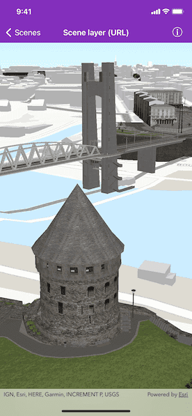
Display an ArcGIS scene layer from a URL.

Use case
Adding a scene layer from a URL allows you to author the scene layer elsewhere in the platform, say with ArcGIS Pro or CityEngine, and then add that scene layer to a scene in Runtime. Loading a scene layer from a URL also permits the layer source to change dynamically without updating the code.
How to use the sample
Pan and zoom to explore the scene.
How it works
- Create an
AGSScenewith a topographic basemap. - Apply the scene to an
AGSSceneView. - Create an
AGSArcGISTiledElevationSourcewith a URL and add it to anAGSSurface. - Apply the surface to the scene.
- Create an
AGSArcGISSceneLayerwith a URL and add it to the scene'soperationalLayersarray.
Relevant API
- AGSArcGISSceneLayer
- AGSScene
- AGSSceneView
About the data
This sample shows a Brest, France Scene hosted on ArcGIS Online.
Tags
3D, buildings, model, scene, service, URL
Sample Code
SceneLayerURLViewController.swift
//
// Copyright 2017 Esri.
//
// Licensed under the Apache License, Version 2.0 (the "License");
// you may not use this file except in compliance with the License.
// You may obtain a copy of the License at
//
// http://www.apache.org/licenses/LICENSE-2.0
//
// Unless required by applicable law or agreed to in writing, software
// distributed under the License is distributed on an "AS IS" BASIS,
// WITHOUT WARRANTIES OR CONDITIONS OF ANY KIND, either express or implied.
// See the License for the specific language governing permissions and
// limitations under the License.
//
import UIKit
import ArcGIS
class SceneLayerURLViewController: UIViewController {
@IBOutlet var sceneView: AGSSceneView!
override func viewDidLoad() {
super.viewDidLoad()
// add the source code button item to the right of navigation bar
(self.navigationItem.rightBarButtonItem as! SourceCodeBarButtonItem).filenames = ["SceneLayerURLViewController"]
// Initialize scene with topographic basemap style.
let scene = AGSScene(basemapStyle: .arcGISTopographic)
// assign scene to the scene view
self.sceneView.scene = scene
// set the viewpoint camera
let point = AGSPoint(x: -4.49779155626782, y: 48.38282454039932, z: 62.013264927081764, spatialReference: .wgs84())
let camera = AGSCamera(location: point, heading: 41.64729875588979, pitch: 71.2017391571523, roll: 0)
self.sceneView.setViewpointCamera(camera)
// add base surface for elevation data
let surface = AGSSurface()
/// The url of the Terrain 3D ArcGIS REST Service.
let worldElevationServiceURL = URL(string: "https://elevation3d.arcgis.com/arcgis/rest/services/WorldElevation3D/Terrain3D/ImageServer")!
let elevationSource = AGSArcGISTiledElevationSource(url: worldElevationServiceURL)
surface.elevationSources.append(elevationSource)
scene.baseSurface = surface
/// The url of the scene service for buildings in Brest, France.
let brestBuildingsServiceURL = URL(string: "https://tiles.arcgis.com/tiles/P3ePLMYs2RVChkJx/arcgis/rest/services/Buildings_Brest/SceneServer/layers/0")!
// scene layer
let sceneLayer = AGSArcGISSceneLayer(url: brestBuildingsServiceURL)
self.sceneView.scene?.operationalLayers.add(sceneLayer)
}
}