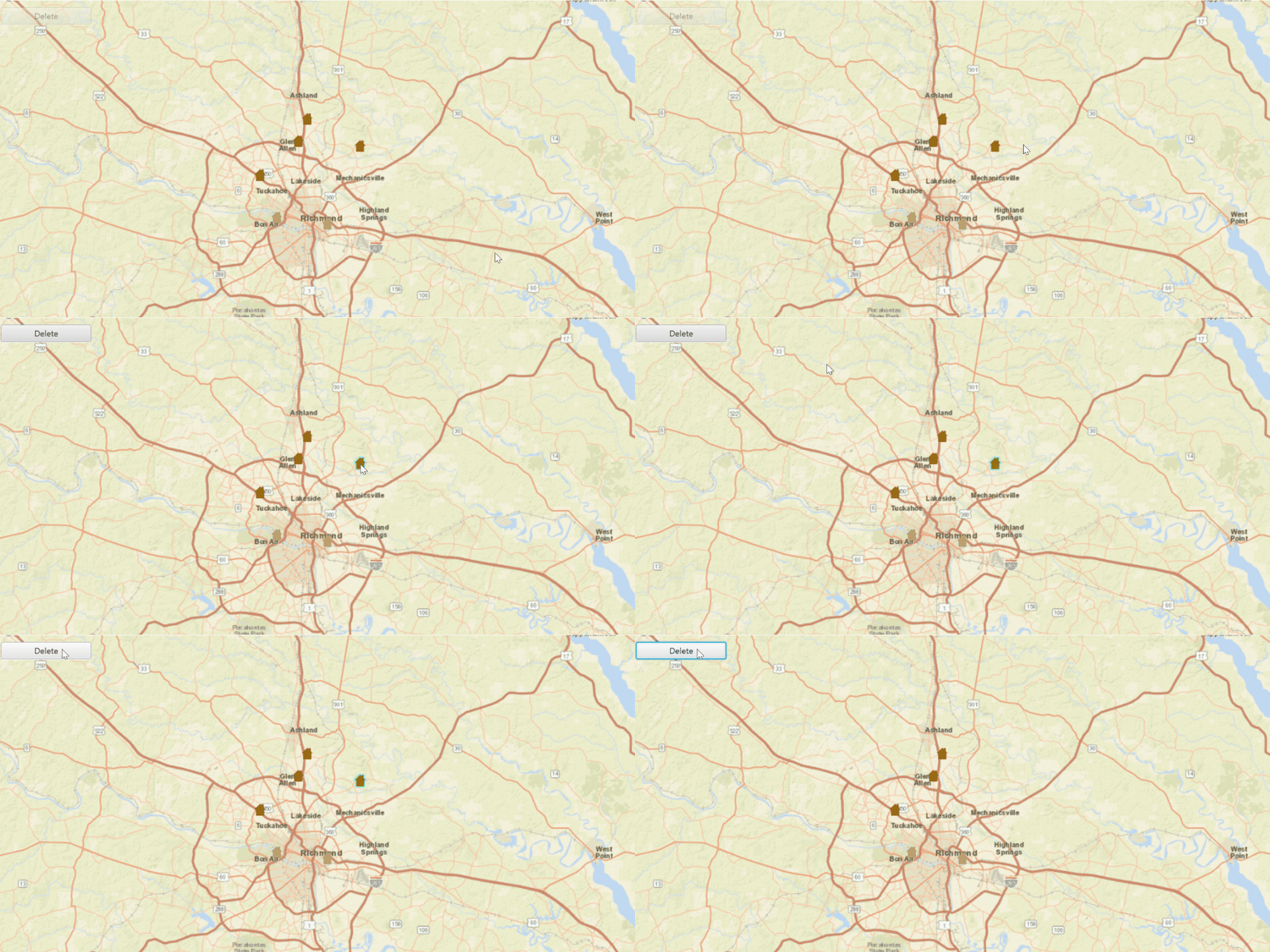
Delete features from an online feature service.

Use case
Sometimes users may want to delete features from an online feature service.
How to use the sample
Click on a feature on the Map, then click the 'delete' button to delete.
How it works
- Create and load a
ServiceGeodatabasewith a feature service URL. - Get the
ServiceFeatureTablefrom the service geodatabase. - Create a
FeatureLayerfrom the service feature table. - Identify the selected feature by using
identifyLayerAsync. - Remove the selected features from the
ServiceFeatureTableusingdeleteFeaturesAsync. - Update the data on the server using
applyEditsAsyncon theServiceGeodatabase, which will remove the feature from the online service.
Relevant API
- Feature
- FeatureLayer
- ServiceFeatureTable
- ServiceGeodatabase
Tags
deletion, feature, online, service, table
Sample Code
DeleteFeaturesSample.java
/*
* Copyright 2017 Esri.
*
* Licensed under the Apache License, Version 2.0 (the "License"); you may not
* use this file except in compliance with the License. You may obtain a copy of
* the License at
*
* http://www.apache.org/licenses/LICENSE-2.0
*
* Unless required by applicable law or agreed to in writing, software
* distributed under the License is distributed on an "AS IS" BASIS, WITHOUT
* WARRANTIES OR CONDITIONS OF ANY KIND, either express or implied. See the
* License for the specific language governing permissions and limitations under
* the License.
*/
package com.esri.samples.delete_features;
import java.util.List;
import java.util.concurrent.ExecutionException;
import java.util.stream.Collectors;
import javafx.application.Application;
import javafx.application.Platform;
import javafx.geometry.Insets;
import javafx.geometry.Point2D;
import javafx.geometry.Pos;
import javafx.scene.Scene;
import javafx.scene.control.Alert;
import javafx.scene.control.Alert.AlertType;
import javafx.scene.control.Button;
import javafx.scene.input.MouseButton;
import javafx.scene.layout.StackPane;
import javafx.stage.Stage;
import com.esri.arcgisruntime.ArcGISRuntimeEnvironment;
import com.esri.arcgisruntime.concurrent.ListenableFuture;
import com.esri.arcgisruntime.data.Feature;
import com.esri.arcgisruntime.data.FeatureTableEditResult;
import com.esri.arcgisruntime.data.FeatureQueryResult;
import com.esri.arcgisruntime.data.ServiceFeatureTable;
import com.esri.arcgisruntime.data.ServiceGeodatabase;
import com.esri.arcgisruntime.layers.FeatureLayer;
import com.esri.arcgisruntime.mapping.ArcGISMap;
import com.esri.arcgisruntime.mapping.BasemapStyle;
import com.esri.arcgisruntime.mapping.Viewpoint;
import com.esri.arcgisruntime.mapping.view.IdentifyLayerResult;
import com.esri.arcgisruntime.mapping.view.MapView;
public class DeleteFeaturesSample extends Application {
private MapView mapView;
private FeatureLayer featureLayer;
private ServiceFeatureTable featureTable;
private Button deleteButton;
private ListenableFuture<FeatureQueryResult> selectionResult;
private static final String FEATURE_LAYER_URL =
"https://sampleserver6.arcgisonline.com/arcgis/rest/services/DamageAssessment/FeatureServer";
@Override
public void start(Stage stage) {
try {
// create stack pane and application scene
StackPane stackPane = new StackPane();
Scene scene = new Scene(stackPane);
// set title, size, and add scene to stage
stage.setTitle("Delete Features Sample");
stage.setWidth(800);
stage.setHeight(700);
stage.setScene(scene);
stage.show();
// authentication with an API key or named user is required to access basemaps and other location services
String yourAPIKey = System.getProperty("apiKey");
ArcGISRuntimeEnvironment.setApiKey(yourAPIKey);
// create a delete button and fill the width of the screen
deleteButton = new Button("Delete");
deleteButton.setMaxWidth(130);
deleteButton.setDisable(true);
// create event to delete the selected features on click
deleteButton.setOnAction(event -> {
// get selected features
selectionResult = featureLayer.getSelectedFeaturesAsync();
selectionResult.addDoneListener(() -> {
try {
FeatureQueryResult selected = selectionResult.get();
// delete selected features
deleteFeatures(selected, featureTable);
} catch (InterruptedException | ExecutionException e) {
displayMessage("Cannot delete features", e.getCause().getMessage());
}
});
});
// create a map with the streets basemap style
ArcGISMap map = new ArcGISMap(BasemapStyle.ARCGIS_STREETS);
// create a map view and set the map to it
mapView = new MapView();
mapView.setMap(map);
// set a viewpoint on the map view
mapView.setViewpoint(new Viewpoint(40, -95, 36978595));
// create a service geodatabase from the service layer url and load it
var serviceGeodatabase = new ServiceGeodatabase(FEATURE_LAYER_URL);
serviceGeodatabase.addDoneLoadingListener(() -> {
// create a service feature table from the first layer on the service geodatabase's table
featureTable = serviceGeodatabase.getTable(0);
// create a feature layer from the feature table
featureLayer = new FeatureLayer(featureTable);
// add the layer to the ArcGISMap
map.getOperationalLayers().add(featureLayer);
});
serviceGeodatabase.loadAsync();
mapView.setOnMouseClicked(event -> {
// check for primary or secondary mouse click
if (event.isStillSincePress() && event.getButton() == MouseButton.PRIMARY) {
// create a point from where the user clicked
Point2D point = new Point2D(event.getX(), event.getY());
// clear any previous selection
featureLayer.clearSelection();
deleteButton.setDisable(true);
// identify the clicked feature
ListenableFuture<IdentifyLayerResult> results = mapView.identifyLayerAsync(featureLayer, point, 1, false);
results.addDoneListener(() -> {
try {
IdentifyLayerResult layer = results.get();
if (!layer.getElements().isEmpty()) {
// search the layers for identified features
List<Feature> features = layer.getElements()
.stream()
.filter(g -> g instanceof Feature)
.map(g -> (Feature) g)
.collect(Collectors.toList());
// add the clicked feature to the selection
if (features.size() > 0) {
featureLayer.selectFeatures(features);
deleteButton.setDisable(false);
}
}
} catch (InterruptedException | ExecutionException e) {
displayMessage("Exception getting identify result", e.getCause().getMessage());
}
});
}
});
// add the map view and control box to stack pane
stackPane.getChildren().addAll(mapView, deleteButton);
StackPane.setAlignment(deleteButton, Pos.TOP_LEFT);
StackPane.setMargin(deleteButton, new Insets(10, 0, 0, 10));
} catch (Exception e) {
// on any error, display the stack trace
e.printStackTrace();
}
}
/**
* Deletes features from a ServiceFeatureTable and applies the changes to the
* server.
*/
private void deleteFeatures(FeatureQueryResult features, ServiceFeatureTable featureTable) {
// delete feature from the feature table and apply edit to server
featureTable.deleteFeaturesAsync(features).addDoneListener(() -> applyEdits(featureTable));
}
/**
* Sends any edits on the ServiceFeatureTable to the server.
*
* @param featureTable service feature table
*/
private void applyEdits(ServiceFeatureTable featureTable) {
// apply the changes to the server
ListenableFuture<List<FeatureTableEditResult>> editResult = featureTable.getServiceGeodatabase().applyEditsAsync();
editResult.addDoneListener(() -> {
try {
List<FeatureTableEditResult> edits = editResult.get();
// check if the server edit was successful
if (edits != null && edits.size() > 0) {
var featureEditResult = edits.get(0).getEditResult().get(0);
if (!featureEditResult.hasCompletedWithErrors()) {
displayMessage(null, "Feature successfully deleted");
deleteButton.setDisable(true);
} else {
throw featureEditResult.getError();
}
}
} catch (InterruptedException | ExecutionException e) {
displayMessage("Exception applying edits on server", e.getCause().getMessage());
}
});
}
/**
* Shows a message in an alert dialog.
*
* @param title title of alert
* @param message message to display
*/
private void displayMessage(String title, String message) {
Platform.runLater(() -> {
Alert dialog = new Alert(AlertType.INFORMATION);
dialog.initOwner(mapView.getScene().getWindow());
dialog.setHeaderText(title);
dialog.setContentText(message);
dialog.showAndWait();
});
}
/**
* Stops and releases all resources used in application.
*/
@Override
public void stop() {
if (mapView != null) {
mapView.dispose();
}
}
/**
* Opens and runs application.
*
* @param args arguments passed to this application
*/
public static void main(String[] args) {
Application.launch(args);
}
}