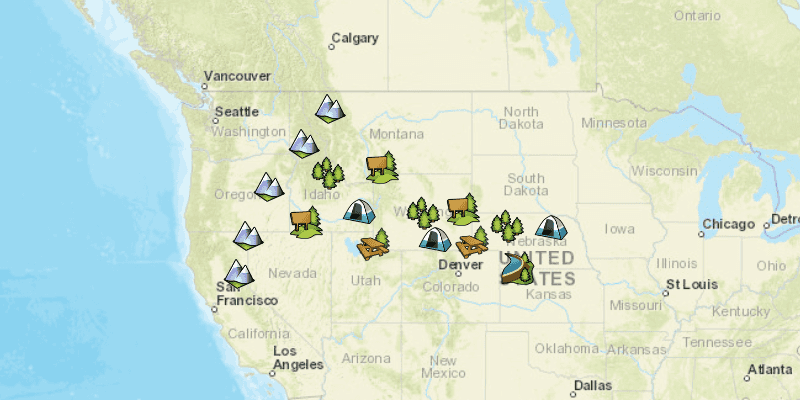
Start a local feature service and display its features in a map.

Use case
For executing offline geoprocessing tasks in your ArcGIS Runtime apps via an offline (local) server.
How to use the sample
A Local Server and Local Feature Service will automatically be started. Once started then a FeatureLayer will be created and added to the map.
How it works
- Create and run a local server with
LocalServer.INSTANCE. - Start the server asynchronously with
Server.startAsync(). - Wait for server to be in the
LocalServerStatus.STARTEDstate.- Callbacks attached to
Server.addStatusChangedListener()will invoke whenever the status of the local server has changed.
- Callbacks attached to
- Create and run a local feature service.
- Instantiate
LocalFeatureService(Url)to create a local feature service with the given url path to mpkx file. - Start the service asynchronously with
LocalFeatureService.startAsync().- The service will be added to the local server automatically.
- Instantiate
- Wait for state of the feature service to be
LocalServerStatus.STARTED.- Callbacks attached to
LocalFeatureService.addStatusChangedListener()will invoke whenever the status of the local service has changed.
- Callbacks attached to
- Create a feature layer from local feature service.
- Create a
ServiceFeatureTable(Url)from local feature service url provided byLocalFeatureService.getUrl(). - Load the table asynchronously using
ServiceFeatureTable.loadAsync(). - Create feature layer from service feature table using
new FeatureLayer(ServiceFeatureTable). - Load the layer asynchronously using
FeatureLayer.loadAsync().
- Create a
- Add feature layer to map using
ArcGISMap.getOperationalLayers().add(FeatureLayer).
Relevant API
- FeatureLayer
- LocalFeatureService
- LocalServer
- LocalServerStatus
- StatusChangedEvent
Additional information
Local Server can be downloaded for Windows and Linux platforms from your ArcGIS Developers dashboard. Local Server is not supported on macOS.
Specific versions of ArcGIS Runtime Local Server are compatible with the version of ArcGIS Pro you use to create geoprocessing and map packages. For example, the ArcGIS Runtime API for Java v100.11.0 is configured for Local Server v100.10.0 which provides compatibility for packages created with ArcGIS Pro 2.7.x. For more information see the ArcGIS Developers guide.
To configure the ArcGIS Runtime API for Java v100.11.0 to work with Local Server 100.9.0:
- Development machine:
- Locate the Local Server installation directory and rename the folder from
LocalServer100.9toLocalServer100.10. - Update the environment variable from
RUNTIME_LOCAL_SERVER_100_9toRUNTIME_LOCAL_SERVER_100_10.
- Locate the Local Server installation directory and rename the folder from
- Deployment machine(s): Rename the deployment folder included with your application (or referenced by the LocalServerEnvironment.InstallPath property) from
LocalServer100.9toLocalServer100.10.
Tags
feature service, local, offline, server, service
Sample Code
/*
* Copyright 2017 Esri.
*
* Licensed under the Apache License, Version 2.0 (the "License"); you may not
* use this file except in compliance with the License. You may obtain a copy of
* the License at
*
* http://www.apache.org/licenses/LICENSE-2.0
*
* Unless required by applicable law or agreed to in writing, software
* distributed under the License is distributed on an "AS IS" BASIS, WITHOUT
* WARRANTIES OR CONDITIONS OF ANY KIND, either express or implied. See the
* License for the specific language governing permissions and limitations under
* the License.
*/
package com.esri.samples.local_server_feature_layer;
import java.io.File;
import javafx.application.Application;
import javafx.application.Platform;
import javafx.geometry.Pos;
import javafx.scene.Scene;
import javafx.scene.control.Alert;
import javafx.scene.control.Alert.AlertType;
import javafx.scene.control.ProgressIndicator;
import javafx.scene.layout.StackPane;
import javafx.stage.Stage;
import com.esri.arcgisruntime.ArcGISRuntimeEnvironment;
import com.esri.arcgisruntime.data.ServiceFeatureTable;
import com.esri.arcgisruntime.geometry.Envelope;
import com.esri.arcgisruntime.layers.FeatureLayer;
import com.esri.arcgisruntime.loadable.LoadStatus;
import com.esri.arcgisruntime.localserver.LocalFeatureService;
import com.esri.arcgisruntime.localserver.LocalServer;
import com.esri.arcgisruntime.localserver.LocalServerStatus;
import com.esri.arcgisruntime.localserver.LocalService.StatusChangedEvent;
import com.esri.arcgisruntime.mapping.ArcGISMap;
import com.esri.arcgisruntime.mapping.BasemapStyle;
import com.esri.arcgisruntime.mapping.Viewpoint;
import com.esri.arcgisruntime.mapping.view.MapView;
public class LocalServerFeatureLayerSample extends Application {
private ArcGISMap map;
private FeatureLayer featureLayer; // keep loadable in scope to avoid garbage collection
private LocalFeatureService featureService;
private MapView mapView;
private ProgressIndicator featureLayerProgress;
private static LocalServer server;
@Override
public void start(Stage stage) {
try {
// create stack pane and application scene
StackPane stackPane = new StackPane();
Scene scene = new Scene(stackPane);
// set title, size, and add scene to stage
stage.setTitle("Local Server Feature Layer Sample");
stage.setWidth(800);
stage.setHeight(700);
stage.setScene(scene);
stage.show();
// authentication with an API key or named user is required to access basemaps and other location services
String yourAPIKey = System.getProperty("apiKey");
ArcGISRuntimeEnvironment.setApiKey(yourAPIKey);
// create a map with the streets basemap style
map = new ArcGISMap(BasemapStyle.ARCGIS_STREETS);
// create a map view and set the map to it
mapView = new MapView();
mapView.setMap(map);
// track progress of loading feature layer to map
featureLayerProgress = new ProgressIndicator(ProgressIndicator.INDETERMINATE_PROGRESS);
featureLayerProgress.setMaxWidth(30);
// check that local server install path can be accessed
if (LocalServer.INSTANCE.checkInstallValid()) {
server = LocalServer.INSTANCE;
server.addStatusChangedListener(status -> {
if (server.getStatus() == LocalServerStatus.STARTED) {
// start feature service
File mpkxFile = new File(System.getProperty("data.dir"), "./samples-data/local_server/PointsofInterest.mpkx");
featureService = new LocalFeatureService(mpkxFile.getAbsolutePath());
featureService.addStatusChangedListener(this::addLocalFeatureLayer);
featureService.startAsync();
}
});
// start local server
server.startAsync();
} else {
Platform.runLater(() -> {
Alert dialog = new Alert(AlertType.INFORMATION);
dialog.initOwner(mapView.getScene().getWindow());
dialog.setHeaderText("Local Server Load Error");
dialog.setContentText("Local Geoprocessing Failed to load.");
dialog.showAndWait();
Platform.exit();
});
}
// add the map view and progress indicator to the stack pane
stackPane.getChildren().addAll(mapView, featureLayerProgress);
StackPane.setAlignment(featureLayerProgress, Pos.CENTER);
} catch (Exception e) {
// on any error, display the stack trace.
e.printStackTrace();
}
}
/**
* Once the feature service starts, a feature layer is created from that service and added to the map.
* <p>
* When the feature layer is done loading the view will zoom to the location of were the features were added.
*
* @param status status of feature service
*/
private void addLocalFeatureLayer(StatusChangedEvent status) {
// check that the feature service has started
if (status.getNewStatus() == LocalServerStatus.STARTED && mapView.getMap() != null) {
// get the url of where feature service is located
String url = featureService.getUrl() + "/0";
// create a feature layer using the url
ServiceFeatureTable featureTable = new ServiceFeatureTable(url);
featureTable.loadAsync();
featureLayer = new FeatureLayer(featureTable);
featureLayer.addDoneLoadingListener(() -> {
Envelope extent = featureLayer.getFullExtent();
if (featureLayer.getLoadStatus() == LoadStatus.LOADED && extent != null) {
mapView.setViewpoint(new Viewpoint(extent));
Platform.runLater(() -> featureLayerProgress.setVisible(false));
} else {
new Alert(Alert.AlertType.ERROR, "Feature Layer Failed to Load!").show();
}
});
featureLayer.loadAsync();
// add feature layer to map
map.getOperationalLayers().add(featureLayer);
}
}
/**
* Stops and releases all resources used in application.
*/
@Override
public void stop() {
if (mapView != null) {
mapView.dispose();
}
}
/**
* Opens and runs application.
*
* @param args arguments passed to this application
*/
public static void main(String[] args) {
Application.launch(args);
}
}