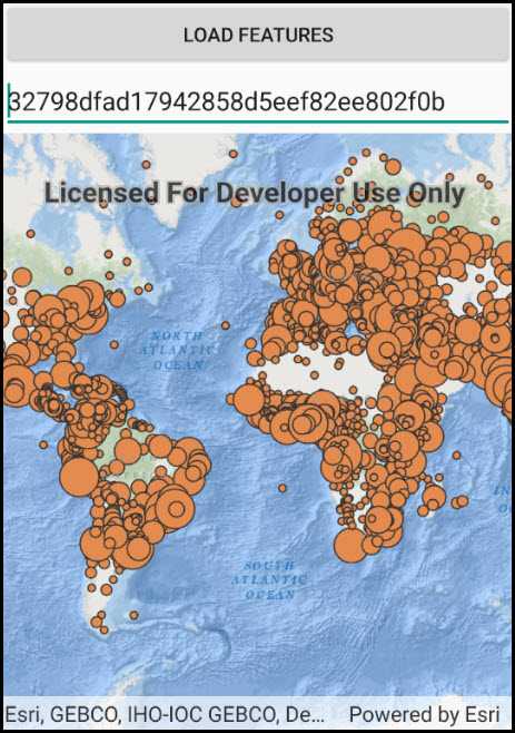
Create a feature collection layer from a portal item.

Use case
Feature collection layers are often used to hold features with mixed geometry or unstructured data. You can display feature collections stored in a Portal, which are often used for showing content from a CSV or map notes.
How to use the sample
The feature collection is loaded from the Portal item when the sample starts.
How it works
- Create a
Portal. - Create the
PortalItem, referring to the portal and an item ID. - Verify that the item represents a feature collection.
- Create a
FeatureCollectionfrom the item. - Create a
FeatureCollectionLayer, referring to the feature collection. - Add the feature collection layer to the map's
OperationalLayerscollection.
Relevant API
- FeatureCollection
- FeatureCollectionLayer
- Portal
- PortalItem
About the data
The sample uses a sample layer depicting world populations.
Tags
collection, feature collection, feature collection layer, id, item, map notes, portal
Sample Code
FeatureCollectionLayerFromPortal.cs
// Copyright 2018 Esri.
//
// Licensed under the Apache License, Version 2.0 (the "License"); you may not use this file except in compliance with the License.
// You may obtain a copy of the License at: http://www.apache.org/licenses/LICENSE-2.0
//
// Unless required by applicable law or agreed to in writing, software distributed under the License is distributed on an
// "AS IS" BASIS, WITHOUT WARRANTIES OR CONDITIONS OF ANY KIND, either express or implied. See the License for the specific
// language governing permissions and limitations under the License.
using Android.App;
using Android.OS;
using Android.Widget;
using Esri.ArcGISRuntime.Data;
using Esri.ArcGISRuntime.Mapping;
using Esri.ArcGISRuntime.Portal;
using Esri.ArcGISRuntime.UI.Controls;
using System;
namespace ArcGISRuntime.Samples.FeatureCollectionLayerFromPortal
{
[Activity (ConfigurationChanges=Android.Content.PM.ConfigChanges.Orientation | Android.Content.PM.ConfigChanges.ScreenSize)]
[ArcGISRuntime.Samples.Shared.Attributes.Sample(
name: "Create feature collection layer (Portal item)",
category: "Layers",
description: "Create a feature collection layer from a portal item.",
instructions: "The feature collection is loaded from the Portal item when the sample starts.",
tags: new[] { "collection", "feature collection", "feature collection layer", "id", "item", "map notes", "portal" })]
public class FeatureCollectionLayerFromPortal : Activity
{
// Hold a reference to the map view.
private MapView _myMapView;
// Store a text box control with a portal item Id.
private EditText _portalItemIdEditText;
// Default portal item Id to load features from.
private const string FeatureCollectionItemId = "32798dfad17942858d5eef82ee802f0b";
protected override void OnCreate(Bundle bundle)
{
base.OnCreate(bundle);
Title = "Create a feature collection layer from a portal item";
// Create the UI.
CreateLayout();
// Initialize the app.
Initialize();
}
private void Initialize()
{
// Add a default value for the portal item Id.
_portalItemIdEditText.Text = FeatureCollectionItemId;
// Create a new map with the oceans basemap and add it to the map view.
_myMapView.Map = new Map(BasemapStyle.ArcGISOceans);
}
private async void OpenFeaturesFromArcGISOnline(string itemId)
{
try
{
// Open a portal item containing a feature collection.
ArcGISPortal portal = await ArcGISPortal.CreateAsync();
PortalItem collectionItem = await PortalItem.CreateAsync(portal, itemId);
// Verify that the item is a feature collection.
if (collectionItem.Type == PortalItemType.FeatureCollection)
{
// Create a new FeatureCollection from the item.
FeatureCollection featureCollection = new FeatureCollection(collectionItem);
// Create a layer to display the collection and add it to the map as an operational layer.
FeatureCollectionLayer featureCollectionLayer = new FeatureCollectionLayer(featureCollection)
{
Name = collectionItem.Title
};
_myMapView.Map.OperationalLayers.Add(featureCollectionLayer);
}
else
{
AlertDialog.Builder alertBuilder = new AlertDialog.Builder(this);
alertBuilder.SetTitle("Feature Collection");
alertBuilder.SetMessage("Portal item with ID '" + itemId + "' is not a feature collection.");
alertBuilder.Show();
}
}
catch (Exception ex)
{
AlertDialog.Builder alertBuilder = new AlertDialog.Builder(this);
alertBuilder.SetTitle("Error");
alertBuilder.SetMessage("Unable to open item with ID '" + itemId + "': " + ex.Message);
alertBuilder.Show();
}
}
private void OpenPortalFeatureCollectionClick(object sender, EventArgs e)
{
// Get the portal item Id from the user.
string collectionItemId = _portalItemIdEditText.Text.Trim();
// Make sure an Id was entered.
if (String.IsNullOrEmpty(collectionItemId))
{
AlertDialog.Builder alertBuilder = new AlertDialog.Builder(this);
alertBuilder.SetTitle("Feature Collection ID");
alertBuilder.SetMessage("Please enter a portal item ID");
alertBuilder.Show();
return;
}
// Call a function to add the feature collection from the specified portal item.
OpenFeaturesFromArcGISOnline(collectionItemId);
}
private void CreateLayout()
{
// Create a new layout.
LinearLayout layout = new LinearLayout(this) { Orientation = Orientation.Vertical };
// Create a button to load features from a portal item, add it to the layout.
Button loadFeaturesButton = new Button(this) { Text = "Load features" };
loadFeaturesButton.Click += OpenPortalFeatureCollectionClick;
layout.AddView(loadFeaturesButton);
// Create an edit text for the user to enter a portal item Id.
_portalItemIdEditText = new EditText(this)
{
Hint = "Portal Item Id"
};
layout.AddView(_portalItemIdEditText);
// Add the map view to the layout.
_myMapView = new MapView(this);
layout.AddView(_myMapView);
// Show the layout in the app.
SetContentView(layout);
}
}
}