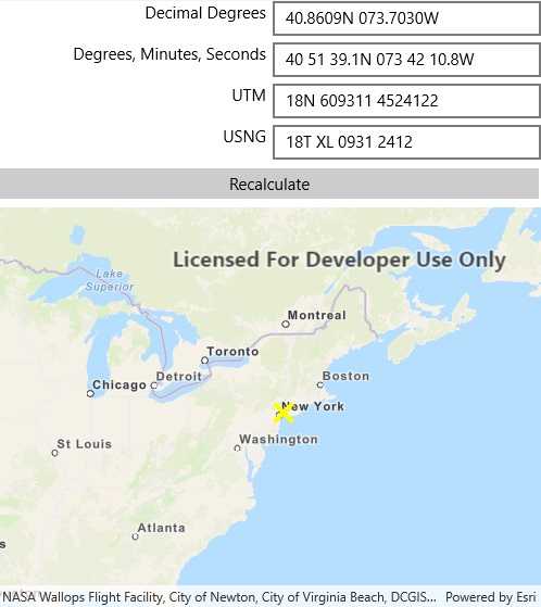
Format coordinates in a variety of common notations.

Use case
The coordinate formatter can format a map location in WGS84 in a number of common coordinate notations. Parsing one of these formats to a location is also supported. Formats include decimal degrees; degrees, minutes, seconds; Universal Transverse Mercator (UTM), and United States National Grid (USNG).
How to use the sample
Tap on the map to see a callout with the tapped location's coordinate formatted in 4 different ways. You can also put a coordinate string in any of these formats in the text field. Hit Enter and the coordinate string will be parsed to a map location which the callout will move to.
How it works
- Get or create a
MapPointwith a spatial reference. - Use one of the static "to" methods on
CoordinateFormattersuch asCoordinateFormatter.ToLatitudeLongitude(point, CoordinateFormatter.LatitudeLongitudeFormat.DecimalDegrees, 4)to get the formatted string. - To go from a formatted string to a
Point, use one of the "from" static methods likeCoordinateFormatter.FromUtm(coordinateString, map.SpatialReference, CoordinateFormatter.UtmConversionMode.NorthSouthIndicators).
Relevant API
- CoordinateFormatter
- CoordinateFormatter.LatitudeLongitudeFormat
- CoordinateFormatter.UtmConversionMode
Tags
convert, coordinate, decimal degrees, degree minutes seconds, format, latitude, longitude, USNG, UTM
Sample Code
<?xml version="1.0" encoding="utf-8" ?>
<ContentPage x:Class="ArcGISRuntime.Samples.FormatCoordinates.FormatCoordinates"
xmlns="http://xamarin.com/schemas/2014/forms"
xmlns:x="http://schemas.microsoft.com/winfx/2009/xaml"
xmlns:esriUI="clr-namespace:Esri.ArcGISRuntime.Xamarin.Forms;assembly=Esri.ArcGISRuntime.Xamarin.Forms">
<Grid>
<Grid.RowDefinitions>
<RowDefinition Height="Auto" />
<RowDefinition Height="Auto" />
<RowDefinition Height="Auto" />
<RowDefinition Height="Auto" />
<RowDefinition Height="Auto" />
<RowDefinition Height="*" />
</Grid.RowDefinitions>
<Grid.ColumnDefinitions>
<ColumnDefinition Width="*" />
<ColumnDefinition Width="*" />
</Grid.ColumnDefinitions>
<Label Grid.Row="0"
Grid.Column="0"
HorizontalTextAlignment="End"
VerticalTextAlignment="Center">
Decimal Degrees
</Label>
<Entry x:Name="DecimalDegreesTextField"
Grid.Row="0"
Grid.Column="1"
Placeholder="Decimal Degrees" />
<Label Grid.Row="1"
Grid.Column="0"
HorizontalTextAlignment="End"
VerticalTextAlignment="Center">
Degrees, Minutes, Seconds
</Label>
<Entry x:Name="DmsTextField"
Grid.Row="1"
Grid.Column="1"
Placeholder="Degrees, Minutes, Seconds" />
<Label Grid.Row="2"
Grid.Column="0"
HorizontalTextAlignment="End"
VerticalTextAlignment="Center">
UTM
</Label>
<Entry x:Name="UtmTextField"
Grid.Row="2"
Grid.Column="1"
Placeholder="UTM" />
<Label Grid.Row="3"
Grid.Column="0"
HorizontalTextAlignment="End"
VerticalTextAlignment="Center">
USNG
</Label>
<Entry x:Name="UsngTextField"
Grid.Row="3"
Grid.Column="1"
Placeholder="USNG" />
<Button Grid.Row="4"
Grid.Column="0"
Grid.ColumnSpan="2"
Clicked="RecalculateFields"
Text="Recalculate" />
<esriUI:MapView x:Name="MyMapView"
Grid.Row="5"
Grid.Column="0"
Grid.ColumnSpan="2" />
</Grid>
</ContentPage>