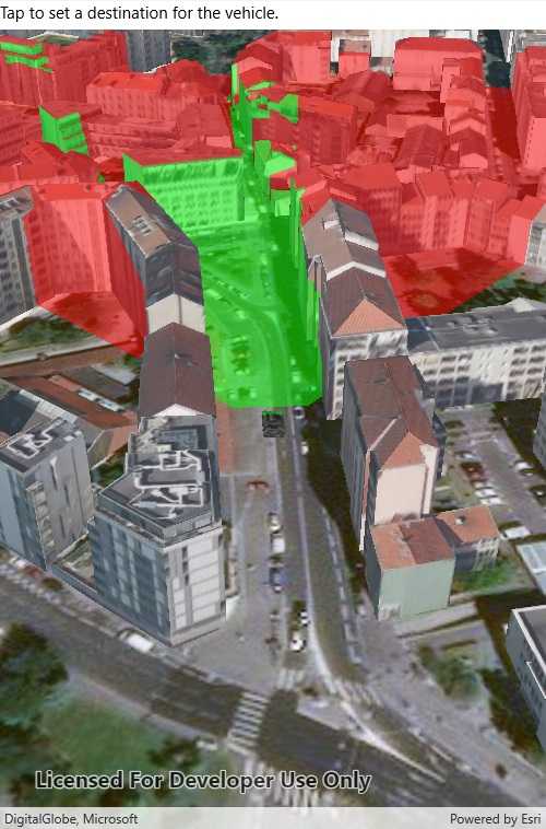
Analyze the viewshed for an object (GeoElement) in a scene.

Use case
A viewshed analysis is a type of visual analysis you can perform on a scene. The viewshed aims to answer the question 'What can I see from a given location?'. The output is an overlay with two different colors - one representing the visible areas (green) and the other representing the obstructed areas (red).
How to use the sample
Tap to set a destination for the vehicle (a GeoElement). The vehicle will 'drive' towards the tapped location. The viewshed analysis will update as the vehicle moves.
How it works
- Create and show the scene, with an elevation source and a buildings layer.
- Add a model (the
GeoElement) to represent the observer (in this case, a tank).- Use a
SimpleRendererwhich has a heading expression set in theGraphicsOverlay. This way you can relate the viewshed's heading to theGeoElementobject's heading.
- Use a
- Create a
GeoElementViewshedwith configuration for the viewshed analysis. - Add the viewshed to an
AnalysisOverlayand add the overlay to the scene. - Configure the SceneView
CameraControllerto orbit the vehicle.
Relevant API
- AnalysisOverlay
- GeodeticDistanceResult
- GeoElementViewshed
- GeometryEngine.DistanceGeodetic
- ModelSceneSymbol
- OrbitGeoElementCameraController
Offline data
This sample downloads the following items from ArcGIS Online automatically:
- bradley_low_3ds.zip - Model Scene Symbol for use in ArcGIS Runtime Samples
About the data
This sample shows a Johannesburg, South Africa Scene from ArcGIS Online. The sample uses a Tank model scene symbol hosted as an item on ArcGIS Online.
Tags
3D, analysis, buildings, model, scene, viewshed, visibility analysis
Sample Code
<?xml version="1.0" encoding="utf-8" ?>
<ContentPage x:Class="ArcGISRuntime.Samples.ViewshedGeoElement.ViewshedGeoElement"
xmlns="http://xamarin.com/schemas/2014/forms"
xmlns:x="http://schemas.microsoft.com/winfx/2009/xaml"
xmlns:esriUI="clr-namespace:Esri.ArcGISRuntime.Xamarin.Forms;assembly=Esri.ArcGISRuntime.Xamarin.Forms">
<StackLayout Orientation="Vertical">
<Label Text="Tap to set a destination for the vehicle." VerticalOptions="Start" />
<esriUI:SceneView x:Name="MySceneView" VerticalOptions="FillAndExpand" />
</StackLayout>
</ContentPage>