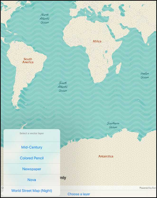
Load an ArcGIS Vector Tiled Layer from a URL.

Use case
Vector tile basemaps can be created in ArcGIS Pro and published as offline packages or online services. ArcGISVectorTiledLayer has many advantages over traditional raster based basemaps (ArcGISTiledLayer), including smooth scaling between different screen DPIs, smaller package sizes, and the ability to rotate symbols and labels dynamically.
How to use the sample
Use the drop down menu to load different vector tile basemaps.
How it works
- An
ArcGISVectorTiledLayeris constructed with an ArcGIS Online service URL - The layer instance is added to the
Map
Relevant API
- ArcGISVectorTiledLayer
- Basemap
Tags
tiles, vector, vector basemap, vector tiled layer, vector tiles
Sample Code
ArcGISVectorTiledLayerUrl.cs
// Copyright 2018 Esri.
//
// Licensed under the Apache License, Version 2.0 (the "License"); you may not use this file except in compliance with the License.
// You may obtain a copy of the License at: http://www.apache.org/licenses/LICENSE-2.0
//
// Unless required by applicable law or agreed to in writing, software distributed under the License is distributed on an
// "AS IS" BASIS, WITHOUT WARRANTIES OR CONDITIONS OF ANY KIND, either express or implied. See the License for the specific
// language governing permissions and limitations under the License.
using System;
using System.Collections.Generic;
using System.Linq;
using Esri.ArcGISRuntime.Geometry;
using Esri.ArcGISRuntime.Mapping;
using Esri.ArcGISRuntime.UI.Controls;
using Foundation;
using UIKit;
namespace ArcGISRuntime.Samples.ArcGISVectorTiledLayerUrl
{
[Register("ArcGISVectorTiledLayerUrl")]
[ArcGISRuntime.Samples.Shared.Attributes.Sample(
name: "ArcGIS vector tiled layer URL",
category: "Layers",
description: "Load an ArcGIS Vector Tiled Layer from a URL.",
instructions: "Use the drop down menu to load different vector tile basemaps.",
tags: new[] { "tiles", "vector", "vector basemap", "vector tiled layer", "vector tiles" })]
public class ArcGISVectorTiledLayerUrl : UIViewController
{
// Hold references to UI controls.
private MapView _myMapView;
private UIBarButtonItem _chooseLayerButton;
// Dictionary maps layer names to URLs.
private readonly Dictionary<string, Uri> _layerUrls = new Dictionary<string, Uri>
{
{"Mid-Century", new Uri("https://www.arcgis.com/home/item.html?id=7675d44bb1e4428aa2c30a9b68f97822")},
{"Colored Pencil", new Uri("https://www.arcgis.com/home/item.html?id=4cf7e1fb9f254dcda9c8fbadb15cf0f8")},
{"Newspaper", new Uri("https://www.arcgis.com/home/item.html?id=dfb04de5f3144a80bc3f9f336228d24a")},
{"Nova", new Uri("https://www.arcgis.com/home/item.html?id=75f4dfdff19e445395653121a95a85db")},
{"World Street Map (Night)", new Uri("https://www.arcgis.com/home/item.html?id=86f556a2d1fd468181855a35e344567f")}
};
public ArcGISVectorTiledLayerUrl()
{
Title = "ArcGIS vector tiled layer (URL)";
}
private void Initialize()
{
Map myMap = new Map(SpatialReferences.WebMercator);
// Create a new ArcGISVectorTiledLayer.
ArcGISVectorTiledLayer vectorTiledLayer = new ArcGISVectorTiledLayer(_layerUrls.Values.First());
// Create and use a new basemap.
myMap.Basemap = new Basemap(vectorTiledLayer);
// Assign the Map to the MapView.
_myMapView.Map = myMap;
}
private void LayerSelectionButtonClick(object sender, EventArgs e)
{
// Create the view controller that will present the list of layers.
UIAlertController layerSelectionAlert = UIAlertController.Create("Select a vector layer", "", UIAlertControllerStyle.ActionSheet);
// Add an option for each layer.
foreach (string item in _layerUrls.Keys)
{
// Selecting the layer will call the ChooseLayer function.
layerSelectionAlert.AddAction(UIAlertAction.Create(item, UIAlertActionStyle.Default, action => ChooseLayer(item)));
}
// Fix to prevent crash on iPad.
var popoverPresentationController = layerSelectionAlert.PopoverPresentationController;
if (popoverPresentationController != null)
{
popoverPresentationController.BarButtonItem = (UIBarButtonItem) sender;
}
// Show the alert.
PresentViewController(layerSelectionAlert, true, null);
}
private void ChooseLayer(string layer)
{
// Get the layer based on the selection.
ArcGISVectorTiledLayer vectorTiledLayer = new ArcGISVectorTiledLayer(_layerUrls[layer]);
// Apply the layer.
_myMapView.Map = new Map(new Basemap(vectorTiledLayer));
}
public override void ViewDidLoad()
{
base.ViewDidLoad();
Initialize();
}
public override void LoadView()
{
// Create the views.
View = new UIView {BackgroundColor = ApplicationTheme.BackgroundColor};
_myMapView = new MapView();
_myMapView.TranslatesAutoresizingMaskIntoConstraints = false;
_chooseLayerButton = new UIBarButtonItem();
_chooseLayerButton.Title = "Choose a layer";
UIToolbar toolbar = new UIToolbar();
toolbar.TranslatesAutoresizingMaskIntoConstraints = false;
toolbar.Items = new[]
{
new UIBarButtonItem(UIBarButtonSystemItem.FlexibleSpace),
_chooseLayerButton,
new UIBarButtonItem(UIBarButtonSystemItem.FlexibleSpace)
};
// Add the views.
View.AddSubviews(_myMapView, toolbar);
// Lay out the views.
NSLayoutConstraint.ActivateConstraints(new[]
{
_myMapView.TopAnchor.ConstraintEqualTo(View.SafeAreaLayoutGuide.TopAnchor),
_myMapView.LeadingAnchor.ConstraintEqualTo(View.LeadingAnchor),
_myMapView.TrailingAnchor.ConstraintEqualTo(View.TrailingAnchor),
_myMapView.BottomAnchor.ConstraintEqualTo(toolbar.TopAnchor),
toolbar.BottomAnchor.ConstraintEqualTo(View.SafeAreaLayoutGuide.BottomAnchor),
toolbar.LeadingAnchor.ConstraintEqualTo(View.LeadingAnchor),
toolbar.TrailingAnchor.ConstraintEqualTo(View.TrailingAnchor),
});
}
public override void ViewWillAppear(bool animated)
{
base.ViewWillAppear(animated);
// Subscribe to events.
_chooseLayerButton.Clicked += LayerSelectionButtonClick;
}
public override void ViewDidDisappear(bool animated)
{
base.ViewDidDisappear(animated);
// Unsubscribe from events, per best practice.
_chooseLayerButton.Clicked -= LayerSelectionButtonClick;
}
}
}