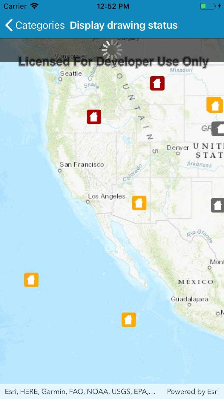
Get the draw status of your map view or scene view to know when all layers in the map or scene have finished drawing.

Use case
You may want to display a loading indicator while layers are loading, which could then be removed on DrawStatus.Completed.
How to use the sample
Pan and zoom around the map. Observe how the status changes from a loading animation to solid, indicating that drawing has completed.
How it works
- Create a
MapViewand subscribe to theDrawStatusChangedevent. - Inspect the draw status property in the event handler to determine draw status.
Relevant API
- Map
- DrawStatus
- DrawStatusChangedEvent
- DrawStatusChangedListener
- MapView
Tags
draw, loading, map, render
Sample Code
DisplayDrawingStatus.cs
// Copyright 2016 Esri.
//
// Licensed under the Apache License, Version 2.0 (the "License"); you may not use this file except in compliance with the License.
// You may obtain a copy of the License at: http://www.apache.org/licenses/LICENSE-2.0
//
// Unless required by applicable law or agreed to in writing, software distributed under the License is distributed on an
// "AS IS" BASIS, WITHOUT WARRANTIES OR CONDITIONS OF ANY KIND, either express or implied. See the License for the specific
// language governing permissions and limitations under the License.
using System;
using Esri.ArcGISRuntime.Data;
using Esri.ArcGISRuntime.Geometry;
using Esri.ArcGISRuntime.Mapping;
using Esri.ArcGISRuntime.UI;
using Esri.ArcGISRuntime.UI.Controls;
using Foundation;
using UIKit;
namespace ArcGISRuntime.Samples.DisplayDrawingStatus
{
[Register("DisplayDrawingStatus")]
[ArcGISRuntime.Samples.Shared.Attributes.Sample(
name: "Display draw status",
category: "MapView",
description: "Get the draw status of your map view or scene view to know when all layers in the map or scene have finished drawing.",
instructions: "Pan and zoom around the map. Observe how the status changes from a loading animation to solid, indicating that drawing has completed.",
tags: new[] { "draw", "loading", "map", "render" })]
public class DisplayDrawingStatus : UIViewController
{
// Hold references to UI controls.
private MapView _myMapView;
private UIActivityIndicatorView _activityIndicator;
private UILabel _statusLabel;
public DisplayDrawingStatus()
{
Title = "Display drawing status";
}
private async void Initialize()
{
// Create new Map with basemap.
Map myMap = new Map(BasemapStyle.ArcGISTopographic);
// URL to the feature service.
Uri serviceUri = new Uri("https://sampleserver6.arcgisonline.com/arcgis/rest/services/DamageAssessment/FeatureServer/0");
// Initialize a new feature layer.
ServiceFeatureTable myFeatureTable = new ServiceFeatureTable(serviceUri);
FeatureLayer myFeatureLayer = new FeatureLayer(myFeatureTable);
// Load the feature layer.
await myFeatureLayer.LoadAsync();
// Add the feature layer to the Map.
myMap.OperationalLayers.Add(myFeatureLayer);
// Provide used Map to the MapView.
_myMapView.Map = myMap;
// Zoom to the United States.
_myMapView.SetViewpointCenterAsync(new MapPoint(-10800000, 4500000, SpatialReferences.WebMercator), 3e7);
// Animate the activity spinner.
_activityIndicator.StartAnimating();
}
private void OnMapViewDrawStatusChanged(object sender, DrawStatusChangedEventArgs e)
{
// Make sure that the UI changes are done in the UI thread.
BeginInvokeOnMainThread(() =>
{
// Show the activity indicator if the map is drawing.
if (e.Status == DrawStatus.InProgress)
{
_activityIndicator.Hidden = false;
_statusLabel.Text = "Drawing status: In progress";
}
else
{
_activityIndicator.Hidden = true;
_statusLabel.Text = "Drawing status: Completed";
}
});
}
public override void ViewDidLoad()
{
base.ViewDidLoad();
Initialize();
}
public override void LoadView()
{
// Create the views.
View = new UIView() { BackgroundColor = ApplicationTheme.BackgroundColor };
_myMapView = new MapView();
_myMapView.TranslatesAutoresizingMaskIntoConstraints = false;
_activityIndicator = new UIActivityIndicatorView(UIActivityIndicatorViewStyle.WhiteLarge)
{
BackgroundColor = UIColor.FromWhiteAlpha(0, .6f),
TranslatesAutoresizingMaskIntoConstraints = false
};
_statusLabel = new UILabel
{
Text = "Drawing status: Unknown",
AdjustsFontSizeToFitWidth = true,
TextAlignment = UITextAlignment.Center,
BackgroundColor = UIColor.FromWhiteAlpha(0, .6f),
TextColor = UIColor.White,
Lines = 1,
TranslatesAutoresizingMaskIntoConstraints = false
};
// Add the views.
View.AddSubviews(_myMapView, _activityIndicator, _statusLabel);
// Lay out the views.
NSLayoutConstraint.ActivateConstraints(new[]
{
_myMapView.TopAnchor.ConstraintEqualTo(View.SafeAreaLayoutGuide.TopAnchor),
_myMapView.BottomAnchor.ConstraintEqualTo(View.BottomAnchor),
_myMapView.LeadingAnchor.ConstraintEqualTo(View.LeadingAnchor),
_myMapView.TrailingAnchor.ConstraintEqualTo(View.TrailingAnchor),
_statusLabel.TopAnchor.ConstraintEqualTo(View.SafeAreaLayoutGuide.TopAnchor),
_statusLabel.LeadingAnchor.ConstraintEqualTo(View.LeadingAnchor),
_statusLabel.TrailingAnchor.ConstraintEqualTo(View.TrailingAnchor),
_statusLabel.HeightAnchor.ConstraintEqualTo(40),
_activityIndicator.TopAnchor.ConstraintEqualTo(_statusLabel.BottomAnchor),
_activityIndicator.LeadingAnchor.ConstraintEqualTo(View.LeadingAnchor),
_activityIndicator.TrailingAnchor.ConstraintEqualTo(View.TrailingAnchor),
_activityIndicator.HeightAnchor.ConstraintEqualTo(40)
});
}
public override void ViewWillAppear(bool animated)
{
base.ViewWillAppear(animated);
// Subscribe to events, removing any existing subscriptions.
_myMapView.DrawStatusChanged -= OnMapViewDrawStatusChanged;
_myMapView.DrawStatusChanged += OnMapViewDrawStatusChanged;
}
public override void ViewDidDisappear(bool animated)
{
base.ViewDidDisappear(animated);
// Unsubscribe from events, per best practice.
_myMapView.DrawStatusChanged -= OnMapViewDrawStatusChanged;
}
}
}