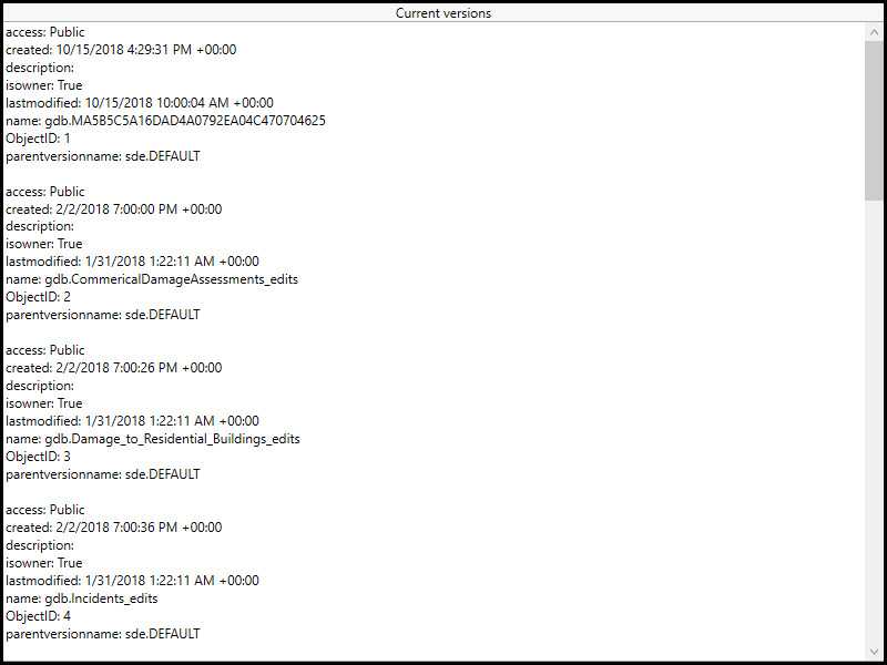
Connect to a service and list versions of the geodatabase.

Use case
As part of a multi-user editing scenario, you can check with the server to see how many versions of the geodatabase are outstanding before syncing.
How to use the sample
When the sample loads, a list of geodatabase versions and their properties will be displayed.
How it works
- Create a geoprocessing task referring to a GPServer with a ListVersions task.
- Use the task to create default parameters.
- Use the created parameters to create a job.
- Run the job to get a
GeoprocessingResult. - Get a list of geoprocessing features from the Versions output parameter of the results.
- Format the geodatabase versions for display.
Relevant API
- GeoprocessingFeatures
- GeoprocessingFeatures.Features
- GeoprocessingJob
- GeoprocessingJob.GetResultAsync
- GeoprocessingParameters
- GeoprocessingResult
- GeoprocessingResult.Outputs
- GeoprocessingTask
- GeoprocessingTask.CreateDefaultParametersAsync
- GeoprocessingTask.CreateJob
About the data
The sample uses a sample geoprocessing service hosted on ArcGIS Online.
Additional information
ArcGIS Server does not include a geoprocessing service for listing geodatabase versions. You must configure one using the steps defined in Geoprocessing service example: list, create, and delete geodatabase versions in the ArcMap documentation.
Tags
conflict resolution, data management, database, multi-user, sync, version
Sample Code
// Copyright 2016 Esri.
//
// Licensed under the Apache License, Version 2.0 (the "License"); you may not use this file except in compliance with the License.
// You may obtain a copy of the License at: http://www.apache.org/licenses/LICENSE-2.0
//
// Unless required by applicable law or agreed to in writing, software distributed under the License is distributed on an
// "AS IS" BASIS, WITHOUT WARRANTIES OR CONDITIONS OF ANY KIND, either express or implied. See the License for the specific
// language governing permissions and limitations under the License.
using Esri.ArcGISRuntime.Data;
using Esri.ArcGISRuntime.Tasks;
using Esri.ArcGISRuntime.Tasks.Geoprocessing;
using System;
using System.Collections.Generic;
using System.Text;
using System.Threading.Tasks;
using System.Windows;
namespace ArcGIS.WPF.Samples.ListGeodatabaseVersions
{
[ArcGIS.Samples.Shared.Attributes.Sample(
name: "List geodatabase versions",
category: "Geoprocessing",
description: "Connect to a service and list versions of the geodatabase.",
instructions: "When the sample loads, a list of geodatabase versions and their properties will be displayed.",
tags: new[] { "conflict resolution", "data management", "database", "multi-user", "sync", "version" })]
public partial class ListGeodatabaseVersions
{
// Url to used geoprocessing service
private const string ListVersionsUrl =
"https://sampleserver6.arcgisonline.com/arcgis/rest/services/GDBVersions/GPServer/ListVersions";
public ListGeodatabaseVersions()
{
InitializeComponent();
// Create the UI, setup the control references and execute initialization
_ = Initialize();
}
private async Task Initialize()
{
// Set the UI to indicate that the geoprocessing is running
SetBusy(true);
try
{
// Get versions from a geodatabase
IFeatureSet versionsFeatureSet = await GetGeodatabaseVersionsAsync();
// Continue if we got a valid geoprocessing result
if (versionsFeatureSet != null)
{
// Create a string builder to hold all of the information from the geoprocessing
// task to display in the UI
StringBuilder myStringBuilder = new StringBuilder();
// Loop through each Feature in the FeatureSet
foreach (Feature version in versionsFeatureSet)
{
// Get the attributes (a dictionary of <key,value> pairs) from the Feature
IDictionary<string, object> myDictionary = version.Attributes;
// Loop through each attribute (a <key,value> pair)
foreach (KeyValuePair<string, object> attribute in myDictionary)
{
// Add the key and value strings to the string builder
myStringBuilder.AppendLine(attribute.Key + ": " + attribute.Value);
}
// Add a blank line after each Feature (the listing of geodatabase versions)
myStringBuilder.AppendLine();
}
// Display the result in the textbox
ResultView.Text = myStringBuilder.ToString();
}
}
catch (Exception e)
{
MessageBox.Show(e.ToString(), "Error");
}
// Set the UI to indicate that the geoprocessing is not running
SetBusy(false);
}
private async Task<IFeatureSet> GetGeodatabaseVersionsAsync()
{
// Results will be returned as a feature set
IFeatureSet results = null;
// Create new geoprocessing task
GeoprocessingTask listVersionsTask = await GeoprocessingTask.CreateAsync(new Uri(ListVersionsUrl));
// Create default parameters that are passed to the geoprocessing task
GeoprocessingParameters listVersionsParameters = await listVersionsTask.CreateDefaultParametersAsync();
// Create job that handles the communication between the application and the geoprocessing task
GeoprocessingJob listVersionsJob = listVersionsTask.CreateJob(listVersionsParameters);
try
{
// Execute analysis and wait for the results
GeoprocessingResult analysisResult = await listVersionsJob.GetResultAsync();
// Get results from the outputs
GeoprocessingFeatures listVersionsResults = (GeoprocessingFeatures)analysisResult.Outputs["Versions"];
// Set results
results = listVersionsResults.Features;
}
catch (Exception ex)
{
// Error handling if something goes wrong
if (listVersionsJob.Status == JobStatus.Failed && listVersionsJob.Error != null)
MessageBox.Show("Executing geoprocessing failed. " + listVersionsJob.Error.Message, "Geoprocessing error");
else
MessageBox.Show("An error occurred. " + ex.ToString(), "Sample error");
}
finally
{
// Set the UI to indicate that the geoprocessing is not running
SetBusy(false);
}
return results;
}
private void SetBusy(bool isBusy = true)
{
if (isBusy)
{
// Change UI to indicate that the geoprocessing is running
BusyOverlay.Visibility = Visibility.Visible;
Progress.IsIndeterminate = true;
}
else
{
// Change UI to indicate that the geoprocessing is not running
BusyOverlay.Visibility = Visibility.Collapsed;
Progress.IsIndeterminate = false;
}
}
}
}