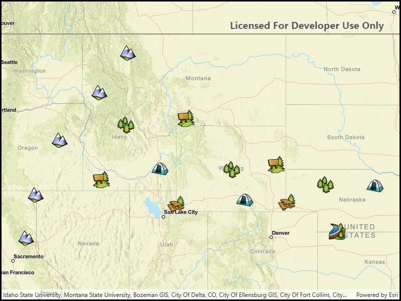
Start a local feature service and display its features in a map.

Use case
For executing offline geoprocessing tasks in your applicationss via an offline (local) server.
How to use the sample
A Local Server and Local Feature Service will automatically be started. Once started then a FeatureLayer will be created and added to the map.
How it works
- Create and run a local server with
LocalServer.Instance. - Start the server asynchronously with
Server.StartAsync(). - Create and run a local feature service.
- Instantiate
LocalFeatureService(Url)to create a local feature service with the given url path to mpk file. - Start the service asynchronously with
LocalFeatureService.StartAsync(). The service will be added to the local server automatically.
- Instantiate
- Create an event handler for the
LocalFeatureService.StatusChangedevent. This will run whenever the status of the local service has changed. - When the service's status has changed to
Started, create a feature layer from local feature service.- Create a
ServiceFeatureTable(Url)using the URL for the feature layer. - Create feature layer from service feature table using
new FeatureLayer(ServiceFeatureTable). - Load the layer asynchronously using
FeatureLayer.LoadAsync().
- Create a
- Add feature layer to map using
Map.OperationalLayers.Add(FeatureLayer).
Relevant API
- FeatureLayer
- LocalFeatureService
- LocalServer
- LocalServerStatus
- StatusChangedEvent
Offline data
This sample downloads the following items from ArcGIS Online automatically:
- PointsofInterest.mpkx - This map package is included in the ArcGIS sample data.
Additional information
Local Server can be downloaded for Windows and Linux platforms from the developers website. Local Server is not supported on macOS.
Tags
feature service, local, offline, server, service
Sample Code
// Copyright 2021 Esri.
//
// Licensed under the Apache License, Version 2.0 (the "License"); you may not use this file except in compliance with the License.
// You may obtain a copy of the License at: http://www.apache.org/licenses/LICENSE-2.0
//
// Unless required by applicable law or agreed to in writing, software distributed under the License is distributed on an
// "AS IS" BASIS, WITHOUT WARRANTIES OR CONDITIONS OF ANY KIND, either express or implied. See the License for the specific
// language governing permissions and limitations under the License.
using ArcGIS.Samples.Managers;
using Esri.ArcGISRuntime.Data;
using Esri.ArcGISRuntime.LocalServices;
using Esri.ArcGISRuntime.Mapping;
using System;
using System.Diagnostics;
using System.IO;
using System.Reflection;
using System.Threading.Tasks;
using System.Windows;
namespace ArcGIS.WPF.Samples.LocalServerFeatureLayer
{
[ArcGIS.Samples.Shared.Attributes.Sample(
name: "Local server feature layer",
category: "Local Server",
description: "Start a local feature service and display its features in a map.",
instructions: "A Local Server and Local Feature Service will automatically be started. Once started then a `FeatureLayer` will be created and added to the map.",
tags: new[] { "feature service", "local", "offline", "server", "service" })]
[ArcGIS.Samples.Shared.Attributes.OfflineData("92ca5cdb3ff1461384bf80dc008e297b")]
public partial class LocalServerFeatureLayer
{
// Hold a reference to the local feature service; the ServiceFeatureTable will be loaded from this service
private LocalFeatureService _localFeatureService;
public LocalServerFeatureLayer()
{
InitializeComponent();
// Create the UI, setup the control references and execute initialization
_ = Initialize();
}
private async Task Initialize()
{
// Create a map and add it to the view
MyMapView.Map = new Map(BasemapStyle.ArcGISStreetsRelief);
try
{
// LocalServer must not be running when setting the data path.
if (LocalServer.Instance.Status == LocalServerStatus.Started)
{
await LocalServer.Instance.StopAsync();
}
// Set the local data path - must be done before starting. On most systems, this will be C:\EsriSamples\AppData.
// This path should be kept short to avoid Windows path length limitations.
string tempDataPathRoot = Directory.GetParent(Environment.GetFolderPath(Environment.SpecialFolder.Windows)).FullName;
string tempDataPath = Path.Combine(tempDataPathRoot, "EsriSamples", "AppData");
Directory.CreateDirectory(tempDataPath); // CreateDirectory won't overwrite if it already exists.
LocalServer.Instance.AppDataPath = tempDataPath;
// Start the local server instance
await LocalServer.Instance.StartAsync();
}
catch (Exception ex)
{
var localServerTypeInfo = typeof(LocalMapService).GetTypeInfo();
var localServerVersion = FileVersionInfo.GetVersionInfo(localServerTypeInfo.Assembly.Location);
MessageBox.Show($"Please ensure that local server {localServerVersion.FileVersion} is installed prior to using the sample. The download link is in the description. Message: {ex.Message}", "Local Server failed to start");
return;
}
// Load the sample data and get the path
string myfeatureServicePath = GetFeatureLayerPath();
// Create the feature service to serve the local data
_localFeatureService = new LocalFeatureService(myfeatureServicePath);
// Listen to feature service status changes
_localFeatureService.StatusChanged += _localFeatureService_StatusChanged;
// Start the feature service
try
{
await _localFeatureService.StartAsync();
}
catch (Exception ex)
{
MessageBox.Show(ex.Message, "The feature service failed to load");
}
}
private async void _localFeatureService_StatusChanged(object sender, StatusChangedEventArgs e)
{
// Load the map from the service once ready
if (e.Status == LocalServerStatus.Started)
{
// Get the path to the first layer - the local feature service url + layer ID
string layerUrl = _localFeatureService.Url + "/0";
// Create the ServiceFeatureTable
ServiceFeatureTable myFeatureTable = new ServiceFeatureTable(new Uri(layerUrl));
// Create the Feature Layer from the table
FeatureLayer myFeatureLayer = new FeatureLayer(myFeatureTable);
// Add the layer to the map
MyMapView.Map.OperationalLayers.Add(myFeatureLayer);
try
{
// Wait for the layer to load
await myFeatureLayer.LoadAsync();
// Set the viewpoint on the MapView to show the layer data
await MyMapView.SetViewpointGeometryAsync(myFeatureLayer.FullExtent, 50);
}
catch (Exception ex)
{
MessageBox.Show(ex.ToString(), "Error");
}
}
}
private static string GetFeatureLayerPath()
{
return DataManager.GetDataFolder("92ca5cdb3ff1461384bf80dc008e297b", "PointsOfInterest.mpkx");
}
}
}