Display a pop-up

Learn how to display feature attributes in a pop-up.

A pop-up, also known as a "popup", is a visual element that displays information about a feature when it is clicked. You typically style and configure a pop-up using HTML and CSS for each layer in a map. Pop-ups can display attribute values, calculated values, or rich content such as images, charts, or videos.

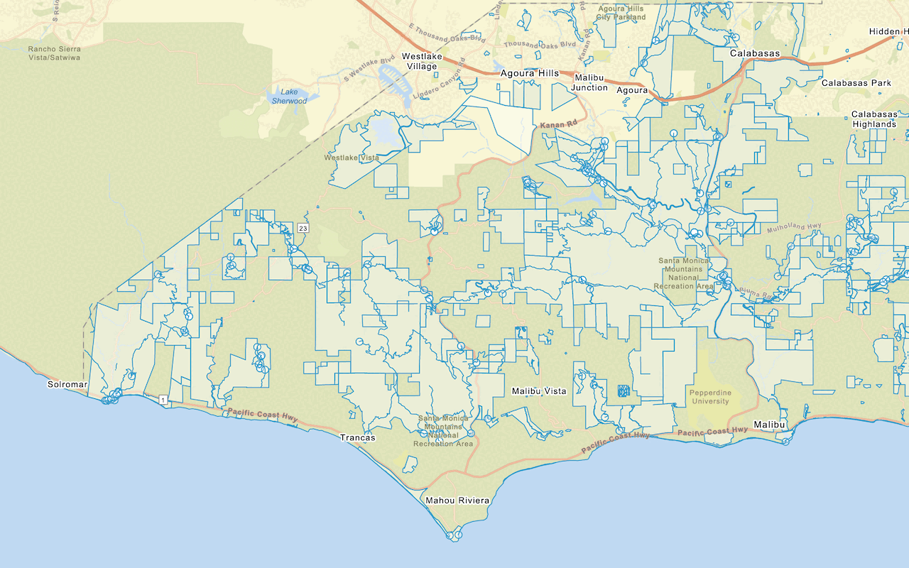
In this tutorial, you create an interactive pop-up for the Trailheads feature layer in the Santa Monica Mountains. When a feature is clicked, a pop-up is displayed containing the name of the trail and the service that manages it. You use the ol-popup library to achieve this.

Prerequisites

You need an ArcGIS Location Platform or ArcGIS Online account.

Steps

Create a new pen

  1. To get started, you can complete the Display a map tutorial or use the .

Get an access token

You need an access token with the correct privileges to access the resources used in this tutorial.

  1. Go to the Create an API key tutorial and create an API key with the following privilege(s):

    • Privileges
      • Location services > Basemaps
    • Item access
      • Note: If you are using your own custom data layer for this tutorial, you need to grant the API key credentials access to the layer item. Learn more in Item access privileges.
  2. Copy the API key access token to your clipboard when prompted.

  3. In CodePen, update the accessToken variable to use your access token.

    Use dark colors for code blocks
    1
    2
    3
    4
    5
    6
    7
    8
    9
    10
    11
    const accessToken = "YOUR_ACCESS_TOKEN";
    const basemapId = "arcgis/outdoor";
    const basemapURL = `https://basemapstyles-api.arcgis.com/arcgis/rest/services/styles/v2/styles/${basemapId}?token=${accessToken}`;
    olms.apply(map, basemapURL);
    
  4. Run the code to ensure the basemap is displayed in the map.

To learn about the other types of authentication available, go to Types of authentication.

Add the pop-up library

OpenLayers does not include a pop-up component. You can use the third-party library ol-popup to simplify adding pop-ups to your map.

  1. In the <head> element, add references to the ol-popup library.

    Expand
    Use dark colors for code blocks
    1
    2
    3
    4
    5
    6
    7
    8
    9
    10
    11
    12
    13
    14
    15
    16
    17
    18
    19
    20
    21
    22
    23
    24
    25
    26
    27
    28
    29
    30
    31
    32
    33
    34
    35
    36
    37
    38
    39
    40
    41
    42
    43
    44
    45
    46
    47
    48
    49
    50
    51
    52
    53
    54
    55
    56
    57
    58
    59
    60
    61
    62
    63
    64
    65
    66
    67
    68
    69
    70
    71
    72
    73
    74
    75
    76
    77
    78
    79
    80
    81
    82
    83
    84
    85
    86
    87
    88
    89
    90
    91
    92
    93
    94
    95
    96
        <link rel="stylesheet" href="https://cdn.jsdelivr.net/npm/ol@v10.1.0/ol.css" type="text/css" />
        <script src="https://cdn.jsdelivr.net/npm/ol@v10.1.0/dist/ol.js"></script>
        <script src="https://cdn.jsdelivr.net/npm/ol-mapbox-style@12.3.5/dist/olms.js" type="text/javascript"></script>
    
        <script src="https://unpkg.com/ol-popup@5.1.1/dist/ol-popup.js"></script>
        <link rel="stylesheet" href="https://unpkg.com/ol-popup@5.1.1/src/ol-popup.css" />
    
    Expand

Add the trailheads layer

Use a Vector layer with a Vector source to display the trailheads as GeoJSON.

  1. Before the olms initialization, create a a Vector layer. Give it a Vector source with a GeoJSON feature format to load and display the trailheads feature layer. Save it to a trailheadsLayer variable.

    Expand
    Use dark colors for code blocks
    1
    2
    3
    4
    5
    6
    7
    8
    9
    10
    11
    12
    13
    14
    15
    16
    17
    18
    19
    20
    21
    22
    23
    24
    25
    26
    27
    28
    29
    30
    31
    32
    33
    34
    35
    36
    37
    38
    39
    40
    41
    42
    43
    44
    45
    46
    47
    48
    49
    50
    51
    52
    53
    54
    55
    56
    57
    58
    59
    60
    61
    62
    63
    64
    65
    66
    67
    68
    69
    70
    71
    72
    73
    74
    75
    76
    77
    78
    79
    80
    81
    82
    83
    84
    85
    86
    87
    88
    89
    90
    91
    92
    93
    94
    95
    96
          const basemapId = "arcgis/outdoor";
    
          const trailheadsLayer = new ol.layer.Vector({
            source: new ol.source.Vector({
              format: new ol.format.GeoJSON(),
              url: `https://services3.arcgis.com/GVgbJbqm8hXASVYi/arcgis/rest/services/Trailheads/FeatureServer/0/query?where=1%3D1&outFields=*&returnGeometry=true&f=pgeojson`,
    
            })
          });
    
    Expand
  2. Add the data attribution for the vector tile layer source.

    • Go to the Trailheads (Santa Monica Mountains) item.
    • Scroll down to the Credits (Attribution) section and copy its value.
    • Create an attribution property and paste the attribution value from the item.
      Expand
      Use dark colors for code blocks
      1
      2
      3
      4
      5
      6
      7
      8
      9
      10
      11
      12
      13
      14
      15
      16
      17
      18
      19
      20
      21
      22
      23
      24
      25
      26
      27
      28
      29
      30
      31
      32
      33
      34
      35
      36
      37
      38
      39
      40
      41
      42
      43
      44
      45
      46
      47
      48
      49
      50
      51
      52
      53
      54
      55
      56
      57
      58
      59
      60
      61
      62
      63
      64
      65
      66
      67
      68
      69
      70
      71
      72
      73
      74
      75
      76
      77
      78
      79
      80
      81
      82
      83
      84
      85
      86
      87
      88
      89
      90
      91
      92
      93
      94
      95
      96
            const basemapId = "arcgis/outdoor";
      
            const trailheadsLayer = new ol.layer.Vector({
              source: new ol.source.Vector({
                format: new ol.format.GeoJSON(),
                url: `https://services3.arcgis.com/GVgbJbqm8hXASVYi/arcgis/rest/services/Trailheads/FeatureServer/0/query?where=1%3D1&outFields=*&returnGeometry=true&f=pgeojson`,
      
                // Attribution text retrieved from https://arcgis.com/home/item.html?id=883cedb8c9fe4524b64d47666ed234a7
                attributions: ['| Los Angeles GeoHub']
      
              })
            });
      
      Expand
  3. Inside olms load handler, use map.addLayer to add this layer to the map.

    Expand
    Use dark colors for code blocks
    1
    2
    3
    4
    5
    6
    7
    8
    9
    10
    11
    12
    13
    14
    15
    16
    17
    18
    19
    20
    21
    22
    23
    24
    25
    26
    27
    28
    29
    30
    31
    32
    33
    34
    35
    36
    37
    38
    39
    40
    41
    42
    43
    44
    45
    46
    47
    48
    49
    50
    51
    52
    53
    54
    55
    56
    57
    58
    59
    60
    61
    62
    63
    64
    65
    66
    67
    68
    69
    70
    71
    72
    73
    74
    75
    76
    77
    78
    79
    80
    81
    82
    83
    84
    85
    86
    87
    88
    89
    90
    91
    92
    93
    94
    95
    96
          olms.apply(map, `https://basemapstyles-api.arcgis.com/arcgis/rest/services/styles/v2/styles/${basemapId}?token=${accessToken}`).then(function (map) {
    
              map.addLayer(trailheadsLayer);
    
              // Add Esri attribution
              // Learn more in https://esriurl.com/attribution
              const source = map.getLayers().item(0).getSource();
              source.setAttributions("Powered by <a href='https://www.esri.com/en-us/home' target='_blank'>Esri</a> | ")
            });
    
    Expand

Initialize the pop-up

A Popup is a type of Overlay. Use map.addOverlay to add it to the map.

  1. Create a new Popup and save it to a popup variable. Add it to the map with map.addOverlay.

    Expand
    Use dark colors for code blocks
    1
    2
    3
    4
    5
    6
    7
    8
    9
    10
    11
    12
    13
    14
    15
    16
    17
    18
    19
    20
    21
    22
    23
    24
    25
    26
    27
    28
    29
    30
    31
    32
    33
    34
    35
    36
    37
    38
    39
    40
    41
    42
    43
    44
    45
    46
    47
    48
    49
    50
    51
    52
    53
    54
    55
    56
    57
    58
    59
    60
    61
    62
    63
    64
    65
    66
    67
    68
    69
    70
    71
    72
    73
    74
    75
    76
    77
    78
    79
    80
    81
    82
    83
    84
    85
    86
    87
    88
    89
    90
    91
    92
    93
    94
    95
    96
              map.addLayer(trailheadsLayer);
    
              // Add Esri attribution
              // Learn more in https://esriurl.com/attribution
              const source = map.getLayers().item(0).getSource();
              source.setAttributions("Powered by <a href='https://www.esri.com/en-us/home' target='_blank'>Esri</a> | ")
            });
    
          const popup = new Popup();
          map.addOverlay(popup);
    
    Expand

Display a pop-up on click

A pop-up can display any HTML content. Use a click event handler to detect the click, then use map.getFeaturesAtPixel to find any trailhead features at the clicked point. You pass a function as a layerFilter to do so.

If the returned array contains at least one feature, you can use Feature.get to extract the trail name (TRL_NAME) and park name (PARK_NAME). You then use popup.show to update the pop-up position and content.

  1. Add a click event handler. Inside, use getFeaturesAtPixel to get an array of trailhead features clicked on.

    Expand
    Use dark colors for code blocks
    1
    2
    3
    4
    5
    6
    7
    8
    9
    10
    11
    12
    13
    14
    15
    16
    17
    18
    19
    20
    21
    22
    23
    24
    25
    26
    27
    28
    29
    30
    31
    32
    33
    34
    35
    36
    37
    38
    39
    40
    41
    42
    43
    44
    45
    46
    47
    48
    49
    50
    51
    52
    53
    54
    55
    56
    57
    58
    59
    60
    61
    62
    63
    64
    65
    66
    67
    68
    69
    70
    71
    72
    73
    74
    75
    76
    77
    78
    79
    80
    81
    82
    83
    84
    85
    86
    87
    88
    89
    90
    91
    92
    93
    94
    95
    96
          const popup = new Popup();
          map.addOverlay(popup);
    
          map.on("click", (event) => {
            let trailName, parkName;
    
            const trailheads = map.getFeaturesAtPixel(event.pixel, {
              layerFilter: (layer) => layer === trailheadsLayer
            });
    
          });
    
    Expand
  2. If there is a trail name to show, use popup.show to set the position and content of the pop-up. Otherwise, use popup.hide to hide it.

    Expand
    Use dark colors for code blocks
    1
    2
    3
    4
    5
    6
    7
    8
    9
    10
    11
    12
    13
    14
    15
    16
    17
    18
    19
    20
    21
    22
    23
    24
    25
    26
    27
    28
    29
    30
    31
    32
    33
    34
    35
    36
    37
    38
    39
    40
    41
    42
    43
    44
    45
    46
    47
    48
    49
    50
    51
    52
    53
    54
    55
    56
    57
    58
    59
    60
    61
    62
    63
    64
    65
    66
    67
    68
    69
    70
    71
    72
    73
    74
    75
    76
    77
    78
    79
    80
    81
    82
    83
    84
    85
    86
    87
    88
    89
    90
    91
    92
    93
    94
    95
    96
            const trailheads = map.getFeaturesAtPixel(event.pixel, {
              layerFilter: (layer) => layer === trailheadsLayer
            });
    
            if (trailheads.length > 0) {
    
              const trailName = trailheads[0].get("TRL_NAME");
              const parkName = trailheads[0].get("PARK_NAME");
              popup.show(event.coordinate, `<b>${trailName}</b></br>${parkName}`);
    
            } else {
              popup.hide();
            }
    
    Expand

Run the app

In CodePen, run your code to display the map.

The map view should display the Trailheads feature layer. When you click a feature, the name of the trailhead and its park name is displayed in a pop-up.

What's next?

Learn how to use additional ArcGIS location services in these tutorials:
Your browser is no longer supported. Please upgrade your browser for the best experience. See our browser deprecation post for more details.