Introduction and objective
Ground surfaces that are impenetrable to water can cause serious environmental problems, including flooding and contaminated runoff. Many local government agencies use impervious surface calculations to compute the storm water bill for properties. That depends on how much impervious area is there in each property.

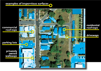
Map highlighting impervious surface areas: driveways, private walks, roof tops, and parking lots [1].
In this notebook, we’ll use a high resolution land cover map obtained from Chesapeake Conservancy to determine which parts of the ground are pervious and impervious.
Impervious surfaces are generally human-made: buildings, roads, parking lots, brick, or asphalt. Pervious surfaces include vegetation, water bodies, and bare soil.
We will reclassify those land-use types into either impervious or pervious surfaces to derive the stormwater bill for each property. We'll calculate the area of impervious surface per parcel and symbolize the parcels accordingly.
Necessary Imports
import pandas as pd
from datetime import datetime as dt

import arcgis
import arcpy
from arcgis.gis import GIS
from arcgis.raster.functions import RFT

gis = GIS('https://pythonapi.playground.esri.com/portal', 'arcgis_python', 'amazing_arcgis_123')
Get data for analysis
For this analysis we need the following datasets:
- Land Cover of Kent County, Delaware
- Kent County parcel feature layer
- Raster Function Template to extract necessary class labels from the land cover layer
In the cells below, we access these datasets from the GIS.
rft_to_reclassify = gis.content.get('eb9fe459cc26486eb4a733b2a2def44f')
rft_to_reclassifyclassified_raster = gis.content.get('7e00802c927a40cbbdc36cefdb2928e4')
classified_rasterclassified_raster.layers[0]
Twelve land cover classes were mapped:
- Water
- Emergent Wetlands
- Tree Canopy
- Scrub/Shrub
- Low Vegetation
- Barren
- Structures
- Other Impervious Surfaces
- Roads
- Tree Canopy over Structures
- Tree Canopy over Other Impervious Surfaces
- Tree Canopy over Roads
The complete class definitions and standards can be viewed at the link below.http://goo.gl/THacgg.
parcels = gis.content.get('1a7e4a24372048048a668c8a176932bf')parcelsparcel_lyr = parcels.layers[0]Classify pixel values into pervious and impervious class
Create the RFT object from raster function template portal item. This object serves as a python function corresponding to the Raster Function Template.
rft_to_reclassify_ob = RFT(rft_to_reclassify)Once an RFT class object has been created, a single question mark before, or after the RFT object will show help relative to it. The help document would display the parameters that were marked as public by the author of the RFT.
rft_to_reclassify_ob?""" RFT to classify pixel values to pervious and impervious class Parameters ---------- Type : 3 Rows : 5 Returns ------- Imagery Layer, on which the function chain is applied """
We can visualize the function chain and the help document specific to this RFT inorder to understand the input parameters and the functions involved.
To view the raster function chain visually, we install graphviz Python library.
# ! conda install graphviz -y# rft_to_reclassify_ob.draw_graph()
Provide the values for the input parameters in the RFT object to create the Imagery Layer.
output = rft_to_reclassify_ob(Raster=classified_raster.layers[0])persisted_output = output.save('generate_reclassified_raster' + str(dt.now().microsecond))impervious_lyr = persisted_output.layers[0]impervious_lyr
Tabulate area of impervious surfaces
We'll determine the area of impervious surfaces within each parcel of land in the neighborhood. We'll first calculate the area and store the results in a stand-alone table. Then, we'll join the table to the Parcels layer.
out_path = '/arcgis/home'arcpy.CreateFileGDB_management(out_path, "output_table.gdb")Impervious field shows the area (in feet) of impervious surfaces per parcel, while Pervious shows the area of pervious surfaces. We will calculate the impervious area with the name field which denotes Parcel_ID.
tabulate_op = arcpy.sa.TabulateArea(in_zone_data=parcel_lyr.url,
                      zone_field="name",
                      in_class_data=impervious_lyr.url,
                      class_field="ClassName",
                      out_table=r"/arcgis/home/output_table.gdb/output_table",
                      impervious_lyr.url)
Now we have the area of impervious surfaces per parcel, but only in a stand-alone table. Next, we'll join the stand-alone table to the Parcels attribute table. A table join updates the input table with the attributes from another table based on a common attribute field. Because we created the impervious area table with the name field from the Parcels layer, we'll perform the join based on that field.
arcpy.management.JoinField(in_data=parcel_lyr.url,
                           in_field="name",
                           join_table="/arcgis/home/output_table.gdb/output_table",
                           join_field="NAME")
Compute stormwater bill
We will now use add_to_definition method which adds a new field to an existing feature layer. We will then calculate percentage of impervious area to determine the tax value.
parcel_lyr.manager.add_to_definition(json_dict={"fields":[{"name":"percent_imp",
                                                           "type":"esriFieldTypeDouble",
                                                           "alias":"percent_imp",
                                                           "nullable":True,
                                                           "editable":True}]})
parcel_lyr.manager.add_to_definition(json_dict={"fields":[{"name":"rate",
                                                           "type":"esriFieldTypeDouble",
                                                           "alias":"rate",
                                                           "nullable":True,
                                                           "editable":True}]})
{'success': True}parcel_lyr.calculate(where="fid > 0",
calc_expression=[{"field":"percent_imp",
"sqlExpression":" ( impervious / ( pervious + impervious ) ) * 100"}])
parcel_lyr.calculate(where="fid > 0",
calc_expression=[{"field":"rate",
"sqlExpression":" impervious * 0.04"}]){'success': True,
'updatedFeatureCount': 83142,
'recordCount': 83142,
'layerName': 'kent_county_parcels'}percent_imp is the percentage of impervious area.
rate is the tax value calculated for $0.04 per square ft of impervious area.
parcel_lyr.manager.delete_from_definition({"fields":[{"name":"name_1"}]}){'success': True}Visualize results
sdf = pd.DataFrame.spatial.from_layer(parcel_lyr)
sdf[['name', 'mailingadd', 'ownercity', 'propertyus', 'impervious', 'pervious', 'percent_imp', 'rate']]| name | mailingadd | ownercity | propertyus | impervious_12 | pervious_12 | percent_imp | rate | |
|---|---|---|---|---|---|---|---|---|
| 0 | 6-00-19700-01-1800-00001 | OF HARRY RONALD WEBB | GREENWOOD | Agricultural-Land | 330.0 | 645297.0 | 0.051113 | 13.20 |
| 1 | 6-00-19700-01-1802-00001 | 4318 MOUNT HOLLY RD | GREENWOOD | Vacant Land | 0.0 | 47.0 | 0.000000 | 0.00 |
| 2 | 6-00-19700-01-1200-00001 | 25 ADAMSVILLE RD | GREENWOOD | Manuf Home/Ret.Title | 2001.0 | 1773.0 | 53.020668 | 80.04 |
| 3 | 6-00-19600-01-5600-00001 | 143 LIDEN SCHOOL RD | GREENWOOD | Single-Fam Residential | 935.0 | 6145.0 | 13.206215 | 37.40 |
| 4 | 6-00-19700-01-5900-00001 | 4299 MT HOLLY ROAD | GREENWOOD | Vacant Land | 89.0 | 2226.0 | 3.844492 | 3.56 |
| ... | ... | ... | ... | ... | ... | ... | ... | ... |
| 83137 | 1 | 291.0 | 94103.0 | 0.308282 | 11.64 | |||
| 83138 | 1 | 291.0 | 94103.0 | 0.308282 | 11.64 | |||
| 83139 | 1 | 291.0 | 94103.0 | 0.308282 | 11.64 | |||
| 83140 | 2-05-06818-01-2402-00001 | 2472.0 | 4624.0 | 34.836528 | 98.88 | |||
| 83141 | 2-05-06818-01-2400-00001 | 3500 S CLARK ST | ARLINGTON | Miscellaneous Imps. | 19834.0 | 2270.0 | 89.730366 | 793.36 |
83142 rows × 8 columns
Symbolize the parcels
m1 = gis.map('Deleware, kent county')
m1
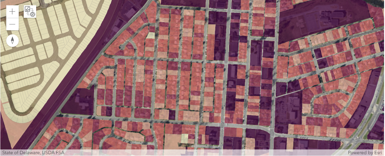
The parcels with the highest area of impervious surfaces are rendered with a darker color while the ones with less impervious surface are light in color. While we could symbolize the layer by the percentage of area that is impervious, most storm water fees are based on total area, not percentage of area. The code below applies this symbology using ClassedColorRenderer.
m1.basemap = 'satellite'm1.extent = {'spatialReference': {'latestWkid': 3857, 'wkid': 102100},
'xmin': -8423844.205248041,
'ymin': 4736924.0084905885,
'xmax': -8386237.187331785,
'ymax': 4752211.414147602}m1.add_layer(lyr, { "type": "FeatureLayer",
"renderer":"ClassedColorRenderer",
"field_name":"impervious",
"opacity":0.7})Conclusion
In this notebook, we reclassified an aerial image of a neighborhood in Louisville, Kentucky, to show areas that were pervious and impervious to water. We then determined the area of impervious surfaces per land parcel. With the information, the local government would be better equipped to determine storm water bills.
