Use the Geometry Editor to edit a geometry and align it to existing geometries on a map.
Use case
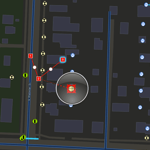
A field worker can create new features by editing and snapping the vertices of a geometry to existing features on a map. In a water distribution network, service line features can be represented with the polyline geometry type. By snapping the vertices of a proposed service line to existing features in the network, an exact footprint can be identified to show the path of the service line and what features in the network it connects to. The feature layer containing the service lines can then be accurately modified to include the proposed line.
How to use the sample
To create a geometry, press the create button to choose the geometry type you want to create (i.e. points, multipoints, polyline, or polygon) and interactively tap and drag on the map view to create the geometry.
Snap settings can be configured by enabling and disabling snapping, feature snapping, geometry guides and snap sources.
To interactively snap a vertex to a feature or graphic, ensure that snapping is enabled for the relevant snap source and move the mouse pointer or drag a vertex to nearby an existing feature or graphic. When the pointer is close to that existing geoelement, the edit position will be adjusted to coincide with (or snap to), edges and vertices of its geometry. Click or release the touch pointer to place the vertex at the snapped location.
To edit a geometry, tap the geometry to be edited in the map to select it and then edit the geometry by tapping and dragging its vertices and snapping them to nearby features or graphics.
To undo changes made to the geometry, press the undo button.
To delete a geometry or a vertex, tap the geometry or vertex to select it and then press the delete button.
To save your edits, press the save button.
How it works
- Create a
Mapfrom theURLand connect it to theMapView. - Set the map's
LoadSettings.featureTilingModetoenabledWithFullResolutionWhenSupported. - Create a
GeometryEditorand connect it to the map view. - Call
syncSourceSettingsafter the map's operational layers are loaded and the geometry editor connected to the map view. - Set
SnapSettings.isEnabledandSnapSourceSettings.isEnabledto true for theSnapSourceof interest. - Toggle geometry guides using
SnapSettings.IsGeometryGuidesEnabledand feature snapping usingSnapSettings.IsFeatureSnappingEnabled. - Start the geometry editor with a
GeometryType.
Relevant API
- FeatureLayer
- Geometry
- GeometryEditor
- GeometryEditorStyle
- GraphicsOverlay
- MapView
- SnapSettings
- SnapSource
- SnapSourceSettings
About the data
The Naperville water distribution network is based on ArcGIS Solutions for Water Utilities and provides a realistic depiction of a theoretical stormwater network.
Additional information
Snapping is used to maintain data integrity between different sources of data when editing, so it is important that each SnapSource provides full resolution geometries to be valid for snapping. This means that some of the default optimizations used to improve the efficiency of data transfer and display of polygon and polyline layers based on feature services are not appropriate for use with snapping.
To snap to polygon and polyline layers, the recommended approach is to set the FeatureLayer's feature tiling mode to FeatureTilingMode::EnabledWithFullResolutionWhenSupported and use the default ServiceFeatureTable feature request mode FeatureRequestMode::OnInteractionCache. Local data sources, such as geodatabases, always provide full resolution geometries. Point and multipoint feature layers are also always full resolution.
Snapping can be used during interactive edits that move existing vertices using the VertexTool or ReticleVertexTool. When adding new vertices, snapping also works with a hover event (such as a mouse move without a mouse button press). Using the ReticleVertexTool to add and move vertices allows users of touch screen devices to clearly see the visual cues for snapping.
Geometry guides are enabled by default when snapping is enabled. These allow for snapping to a point coinciding with, parallel to, perpendicular to or extending an existing geometry.
On supported platforms haptic feedback on SnapState::SnappedToFeature and SnapState::SnappedToGeometryGuide is enabled by default when snapping is enabled. Custom haptic feedback can be configured by setting SnapSettings::isHapticFeedbackEnabled to false and listening to GeometryEditor::snapChanged events to provide specific feedback depending on the SnapState.
Tags
edit, feature, geometry editor, graphics, layers, map, snapping
Sample Code
// [WriteFile Name=SnapGeometryEdits, Category=EditData]
// [Legal]
// Copyright 2024 Esri.
//
// Licensed under the Apache License, Version 2.0 (the "License");
// you may not use this file except in compliance with the License.
// You may obtain a copy of the License at
// http://www.apache.org/licenses/LICENSE-2.0
//
// Unless required by applicable law or agreed to in writing, software
// distributed under the License is distributed on an "AS IS" BASIS,
// WITHOUT WARRANTIES OR CONDITIONS OF ANY KIND, either express or implied.
// See the License for the specific language governing permissions and
// limitations under the License.
// [Legal]
#ifdef PCH_BUILD
#include "pch.hpp"
#endif // PCH_BUILD
// sample headers
#include "SnapGeometryEdits.h"
#include "SnapSourceListModel.h"
// ArcGIS Maps SDK headers
#include "FeatureLayer.h"
#include "FeatureTable.h"
#include "Geometry.h"
#include "GeometryEditor.h"
#include "GeometryEditorElement.h"
#include "GeometryTypes.h"
#include "Graphic.h"
#include "GraphicListModel.h"
#include "GraphicsOverlay.h"
#include "GraphicsOverlayListModel.h"
#include "IdentifyGraphicsOverlayResult.h"
#include "Layer.h"
#include "LayerListModel.h"
#include "LoadSettings.h"
#include "Map.h"
#include "MapQuickView.h"
#include "MapTypes.h"
#include "Portal.h"
#include "PortalItem.h"
#include "ReticleVertexTool.h"
#include "SimpleFillSymbol.h"
#include "SimpleLineSymbol.h"
#include "SimpleMarkerSymbol.h"
#include "SnapSettings.h"
#include "SnapSourceSettings.h"
#include "SymbolTypes.h"
// Qt headers
#include <QFuture>
#include <QtGlobal>
#ifdef Q_OS_ANDROID
#include "ArcGISRuntimeEnvironment.h"
#include <QCoreApplication>
#include <QJniObject>
#endif
using namespace Esri::ArcGISRuntime;
SnapGeometryEdits::SnapGeometryEdits(QObject* parent /* = nullptr */) :
QObject(parent),
m_snapSourceListModel(new SnapSourceListModel(this))
{
PortalItem* portalItem = new PortalItem("b95fe18073bc4f7788f0375af2bb445e", this);
m_map = new Map(portalItem, this);
#ifdef Q_OS_ANDROID
ArcGISRuntimeEnvironment::setAndroidApplicationContext(QJniObject{QNativeInterface::QAndroidApplication::context()});
#endif
m_geometryEditor = new GeometryEditor(this);
m_graphicsOverlay = new GraphicsOverlay(this);
// if mobile, use ReticleVertexTool
#if defined(Q_OS_IOS) || defined(Q_OS_ANDROID)
m_geometryEditor->setTool(new ReticleVertexTool(this));
#endif // defined(Q_OS_IOS) || defined(Q_OS_ANDROID)
connect (m_map, &Map::doneLoading, this, [this]()
{
for (Layer* layer : *m_map->operationalLayers())
{
connect (layer, &Layer::doneLoading, this, [this]()
{
// Enable snap settings after layers load
if (m_layersLoaded == false)
{
m_layersLoaded = true;
emit layersLoadedChanged();
}
});
}
});
}
SnapGeometryEdits::~SnapGeometryEdits() = default;
void SnapGeometryEdits::init()
{
// Register the map view for QML
qmlRegisterType<MapQuickView>("Esri.Samples", 1, 0, "MapView");
qmlRegisterType<SnapGeometryEdits>("Esri.Samples", 1, 0, "SnapGeometryEditsSample");
}
MapQuickView* SnapGeometryEdits::mapView() const
{
return m_mapView;
}
// Set the view (created in QML)
void SnapGeometryEdits::setMapView(MapQuickView* mapView)
{
if (!mapView || mapView == m_mapView)
return;
m_mapView = mapView;
m_mapView->setMap(m_map);
// Enable feature tiling mode to load geometries with full resolution for snapping support
m_map->loadSettings()->setFeatureTilingMode(FeatureTilingMode::EnabledWithFullResolutionWhenSupported);
m_mapView->graphicsOverlays()->append(m_graphicsOverlay);
// Set the geometry editor on the map view
m_mapView->setGeometryEditor(m_geometryEditor);
emit mapViewChanged();
createInitialSymbols();
createConnections();
}
// Create symbols used by all graphics
void SnapGeometryEdits::createInitialSymbols()
{
m_pointSymbol = new SimpleMarkerSymbol(SimpleMarkerSymbolStyle::Square, QColor(255, 45, 0), 10, this);
m_multiPointSymbol = new SimpleMarkerSymbol(SimpleMarkerSymbolStyle::Square, QColor(255, 45, 0), 10, this);
m_lineSymbol = new SimpleLineSymbol(SimpleLineSymbolStyle::Solid, QColor(255, 45, 0), 2, this);
m_polygonSymbol = new SimpleFillSymbol(SimpleFillSymbolStyle::Solid, QColor(255, 0, 0, 75),
new SimpleLineSymbol(SimpleLineSymbolStyle::Dash, QColor(0, 0, 0), 1.0, this), this);
}
void SnapGeometryEdits::createConnections()
{
// Allow user to edit existing graphics by clicking on them
connect (m_mapView, &MapQuickView::mouseClicked, this, [this](const QMouseEvent& mouseEvent)
{
if (!m_geometryEditor->isStarted())
{
m_mapView->identifyGraphicsOverlayAsync(m_graphicsOverlay, mouseEvent.position(), 10, false).then(this, [this](IdentifyGraphicsOverlayResult* result)
{
// Handle editing selected graphics, if any
auto identifyResult = std::unique_ptr<IdentifyGraphicsOverlayResult>(result);
// Return if no graphics were identified
if (identifyResult->graphics().isEmpty())
return;
m_editingGraphic = identifyResult->graphics().first();
// Hide the graphic currently being edited
m_editingGraphic->setVisible(false);
// Start the geometry editor with the graphic's geometry
m_geometryEditor->start(m_editingGraphic->geometry());
emit geometryEditorStartedChanged();
});
}
emit canUndoChanged();
emit isElementSelectedChanged();
});
// Enable or disable buttons when mouse is released (ie after a drag operation)
connect(m_mapView, &MapQuickView::mouseReleased, this, [this](const QMouseEvent&)
{
emit canUndoChanged();
emit isElementSelectedChanged();
});
}
bool SnapGeometryEdits::geometryEditorStarted() const
{
return (m_geometryEditor && m_geometryEditor->isStarted());
}
bool SnapGeometryEdits::canUndo()
{
return (m_geometryEditor && m_geometryEditor->canUndo());
}
bool SnapGeometryEdits::isElementSelected()
{
return (m_geometryEditor && m_geometryEditor->selectedElement() && m_geometryEditor->selectedElement()->canDelete());
}
// Toggles snapping using the enabled state from the snap settings
void SnapGeometryEdits::snappingEnabledStatus(bool snappingCheckedState)
{
m_geometryEditor->snapSettings()->setEnabled(snappingCheckedState);
}
// Toggles geometry guides using the enabled state from the snap settings
void SnapGeometryEdits::geometryGuidesEnabledStatus(bool geometryGuidesCheckedState)
{
m_geometryEditor->snapSettings()->setGeometryGuidesEnabled(geometryGuidesCheckedState);
}
// Toggles feature snapping using the enabled state from the snap settings
void SnapGeometryEdits::featureSnappingEnabledStatus(bool featureSnappingCheckedState)
{
m_geometryEditor->snapSettings()->setFeatureSnappingEnabled(featureSnappingCheckedState);
}
// Starts the GeometryEditor using the selected geometry type
void SnapGeometryEdits::startEditor(GeometryEditorMode geometryEditorMode)
{
switch (geometryEditorMode)
{
case GeometryEditorMode::PointMode:
m_geometryEditor->start(Esri::ArcGISRuntime::GeometryType::Point);
break;
case GeometryEditorMode::MultipointMode:
m_geometryEditor->start(Esri::ArcGISRuntime::GeometryType::Multipoint);
break;
case GeometryEditorMode::PolylineMode:
m_geometryEditor->start(Esri::ArcGISRuntime::GeometryType::Polyline);
break;
case GeometryEditorMode::PolygonMode:
m_geometryEditor->start(Esri::ArcGISRuntime::GeometryType::Polygon);
break;
default:
break;
}
emit geometryEditorStartedChanged();
}
Symbol* SnapGeometryEdits::determineGeometrySymbol(const Geometry& geometry)
{
Symbol* geometrySymbol = nullptr;
switch (geometry.geometryType())
{
case GeometryType::Point:
geometrySymbol = m_pointSymbol;
break;
case GeometryType::Multipoint:
geometrySymbol = m_multiPointSymbol;
break;
case GeometryType::Polyline:
geometrySymbol = m_lineSymbol;
break;
case GeometryType::Polygon:
geometrySymbol = m_polygonSymbol;
break;
default:
break;
}
return geometrySymbol;
}
// Stops the GeometryEditor and append the new graphic to the graphics overlay
void SnapGeometryEdits::stopEditing()
{
const Geometry geometry = m_geometryEditor->stop();
emit geometryEditorStartedChanged();
if (m_editingGraphic)
{
m_editingGraphic->setGeometry(geometry);
m_editingGraphic->setVisible(true);
m_editingGraphic = nullptr;
return;
}
Symbol* geometrySymbol = determineGeometrySymbol(geometry);
if (geometrySymbol)
{
m_graphicsOverlay->graphics()->append(new Graphic(geometry, geometrySymbol, this));
}
}
// Deletes the selected element
void SnapGeometryEdits::deleteSelection()
{
m_geometryEditor->deleteSelectedElement();
emit canUndoChanged();
}
// Reverts the last event on the geometry editor
void SnapGeometryEdits::editorUndo()
{
m_geometryEditor->undo();
emit canUndoChanged();
}
void SnapGeometryEdits::displaySnapSources()
{
if (!m_snapSourceListModel)
return;
// Sync the snap settings and update the list model
m_geometryEditor->snapSettings()->syncSourceSettings();
m_snapSourceListModel->setSnapSourceSettings(m_geometryEditor->snapSettings()->sourceSettings());
emit snapSourceModelChanged();
}
void SnapGeometryEdits::enableAllLayersInSection(const QString& section)
{
m_snapSourceListModel->enableAllLayersInSection(section);
emit snapSourceModelChanged();
}
QAbstractListModel* SnapGeometryEdits::snapSourceListModel() const
{
return m_snapSourceListModel;
}