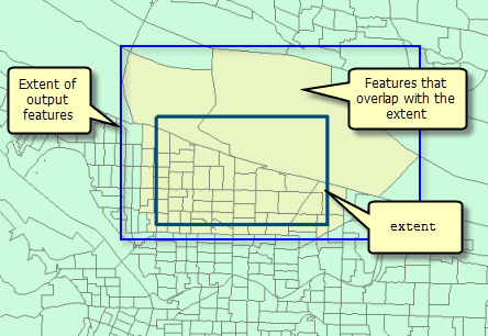
Tasks that have the extent property in their context parameter will process only rasters and features that overlap the specified extent. The output will have an extent that is the same or larger than the extent setting.
Extent syntax:
"extent": {
"xmin": <minimum x-coordinate>,
"ymin": <minimum y-coordinate>,
"xmax": <maximum x-coordinate>,
"ymax": <maximum y-coordinate>,
"spatialReference": {"wkid": <spatial reference well-known identifier>}
}See the Spatial Reference topic for information about setting a WKID and the spatial property.
Extent example:
"extent": {
"xmin": -122.68,
"ymin": 45.53,
"xmax": -122.45,
"ymax": 45.6,
"spatialReference": {
"wkid": 4326
}
}The extent property is useful when you need to process only a portion of a larger raster dataset. You can think of this setting as a rectangle used to extract an area of input raster dataset for processing. Any pixels that are within the rectangle defined by the extent will be processed.
It is recommended that you always set the extent to the area you are analyzing. Doing so limits the number of pixels or features the task needs to examine and will remove any geographically erroneous data from analysis. If you do not set extent , the entire input layer(s) will potentially be analyzed.
Feature extent
When your output is a feature, the rectangle is used only to select features, not to clip them. The extent of the output dataset may be larger than the extent setting to account for features that overlap the extent rectangle.
