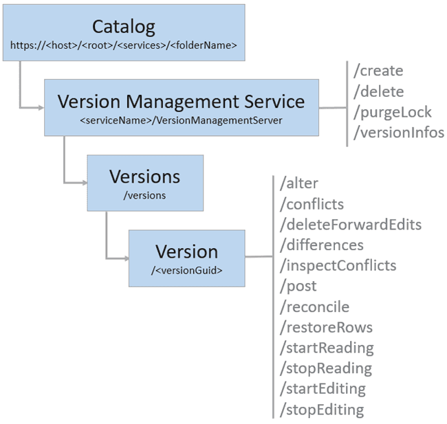
- URL:
- https://<root>/<serviceName>/VersionManagementServer
- Methods:
GET- Operations:
- Create, Delete, Version Infos, Purge Lock
- Child Resources:
- Versions
- Version Introduced:
- 10.6
Description
The Version service exposes the management capabilities necessary to support feature services that work with branch versioned datasets. This service is available when sharing to ArcGIS Enterprise by enabling the Version management capability. To learn more, see Additional layers and capabilities.
The following are supported operations for the Version service:
The version resource returns information about a single version and supports many operations for that version.
 The version management server shares service instance settings and is tied to the published feature service as a server object extension (SOE).
Learn how to configure service instance settings
Usage requirements
When using the Version resources and operations, keep the following in mind:
-
The portal account is used to access resources and operations of the version management server. This account determines whether the operation is allowed by the portal user as well as the results that are returned. For example, the
versionsresource only lists versions the current portal account has access to. -
A read or edit session must be started before running certain operations. Read and edit sessions are started by calling the
startandReading startoperations, respectively.Editing -
Locks must be obtained on a version when running certain operations. Each operation will try to place the necessary lock on the version before processing and will fail if it cannot acquire the appropriate lock. The following lock modes are available in a geodatabase:
- Shared lock—Operations that allow more than one user to access a version require a shared lock.
- Exclusive lock—Operations that must be performed in isolation require an exclusive lock on the version.
Capabilities
The capabilities property was introduced at ArcGIS Enterprise 10.8.1. This property returns the capabilities the service supports. Refer to the JSON Response syntax section below for the ArcGIS Enterprise version when each capability was first introduced:
supports—The reconcile operation supports theConflict Detection By Attribute conflictparameter to allow conflicts to be defined by attribute. Services that don't support this capability define all conflicts by object.Detection supports—The post operation supports using thePartial Post rowsparameter to support posting a portion of the edits (differences) in the version to default.supports—TheDifferences With Moment differencesoperation supports using thefromparameter to allow a user to obtain differences between two moments.Moment supports—TheDifferences With Layers differencesoperation supports using thelayersparameter to allow users to filter the differences returned by layer instead of getting differences for all layers.supportsreconcileAsync Reconcile — The operation supports asynchronous processing using theasync` parameter.supports—TheAsync Post postoperation supports asynchronous processing using theasyncparameter.supports—TheAsync Differences differencesoperation supports asynchronous processing using theasyncparameter.supports—TheOut SR differencesandconflictsoperations support theoutparameter.SR
JSON Response syntax
{
"name": "Version Management Server",
"type": "Map Server Extension",
"defaultVersionName": "<versionName>"
"defaultVersionGuid": <guid>,
"capabilities": {
"supportsConflictDetectionByAttribute": <true | false>, //Introduced at 10.8.1
“supportsPartialPost” : <true | false>, //Introduced at 10.9
"supportsDifferencesFromMoment" : <true | false>, //Introduced at 10.9
"supportsDifferencesWithLayers" : <true | false>, //Introduced at 10.9.1
"supportsAsyncReconcile" : <true | false>, //Introduced at 10.9.1
"supportsAsyncPost" : <true | false>, //Introduced at 10.9.1
"supportsAsyncDifferences" : <true | false>, //Introduced at 10.9.1
"supportsOutSR" : <true | false>, //Introduced at 11.1
}
}Example usage
The following is a request URL example:
https
JSON response:
{
"name": "Version Management Server",
"type": "Map Server Extension",
"defaultVersionName": "SDE.DEFAULT",
"defaultVersionGuid": "{BD3F4817-9A00-41AC-B0CC-58F78DBAE0A1}",
"capabilities": {
"supportsConflictDetectionByAttribute": true,
“supportsPartialPost”: true,
"supportsDifferencesFromMoment": true,
"supportsDifferencesWithLayers": true,
"supportsAsyncReconcile": true,
"supportsAsyncPost": true,
"supportsAsyncDifferences": true,
"supportsOutSR": true
}
}