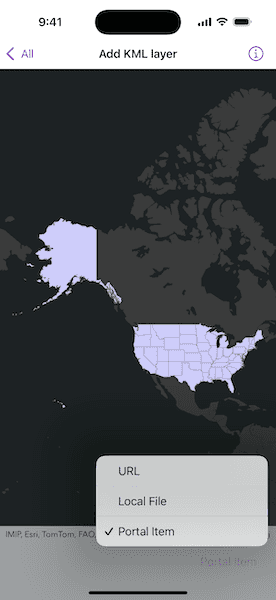
Display KML from a URL, portal item, or local KML file.

Use case
Keyhole Markup Language (KML) is a data format used by Google Earth. KML is popular as a transmission format for consumer use and for sharing geographic data between apps. You can use the Maps SDKs to display KML files, with full support for a variety of features, including network links, 3D models, screen overlays, and tours.
How to use the sample
Use the picker to select a source. A KML layer created from that source will then be displayed in the map.
How it works
- To create a KML layer from a URL, create a
KMLDatasetwith the URL to the KML file. Then, create aKMLLayerusing the dataset. - To create a KML layer from a portal item, create a
PortalItemwith aPortaland the KML portal item ID. Then, create aKMLLayerusing the portal item. - To create a KML layer from a local file, create a
KMLDatasetusing the absolute file path to the local KML file. Then, create aKMLLayerusing the dataset. - Add the layer to the map with
addOperationalLayer(_:).
Relevant API
- KMLDataset
- KMLLayer
Offline data
This sample uses the US State Capitals KML file. It is downloaded from ArcGIS Online automatically.
About the data
This sample displays three different KML files:
- From URL: This is a map of the significant weather outlook produced by NOAA/NWS. It uses KML network links to always show the latest data.
- From local file: This is a map of U.S. state capitals. It doesn't define an icon, so the default pushpin is used for the points.
- From portal item: This is a map of U.S. states.
Tags
keyhole, KML, KMZ, OGC
Sample Code
// Copyright 2024 Esri
//
// Licensed under the Apache License, Version 2.0 (the "License");
// you may not use this file except in compliance with the License.
// You may obtain a copy of the License at
//
// https://www.apache.org/licenses/LICENSE-2.0
//
// Unless required by applicable law or agreed to in writing, software
// distributed under the License is distributed on an "AS IS" BASIS,
// WITHOUT WARRANTIES OR CONDITIONS OF ANY KIND, either express or implied.
// See the License for the specific language governing permissions and
// limitations under the License.
import ArcGIS
import SwiftUI
struct AddKMLLayerView: View {
/// The view model for the sample.
@StateObject private var model = Model()
/// The viewpoint used to update the map view.
@State private var viewpoint: Viewpoint?
/// The KML layer source selected by the picker.
@State private var selectedLayerSource = KMLLayerSource.url
var body: some View {
MapView(map: model.map, viewpoint: viewpoint)
.toolbar {
ToolbarItem(placement: .bottomBar) {
Picker("KML Layer Source", selection: $selectedLayerSource) {
ForEach(KMLLayerSource.allCases, id: \.self) { source in
Text(source.label)
}
}
.onChange(of: selectedLayerSource, perform: setKMLLayer(forSource:))
}
}
.task {
// Loads all the KML layers when the sample opens.
let kmlLayers = [model.urlLayer, model.localFileLayer, model.portalItemLayer]
await kmlLayers.load()
setKMLLayer(forSource: selectedLayerSource)
}
}
/// Sets a KML layer on the map.
/// - Parameter source: The source that was used to create the KML layer.
private func setKMLLayer(forSource source: KMLLayerSource) {
let kmlLayer = switch source {
case .url: model.urlLayer
case .localFile: model.localFileLayer
case .portalItem: model.portalItemLayer
}
// Replaces the current KML layer on the map.
model.map.removeAllOperationalLayers()
model.map.addOperationalLayer(kmlLayer)
// Zooms the map view's viewpoint to the layer.
guard let layerExtent = kmlLayer.fullExtent else { return }
let expandedExtent = layerExtent.withBuilder { $0.expand(by: 1.1) }
viewpoint = Viewpoint(boundingGeometry: expandedExtent)
}
}
private extension AddKMLLayerView {
/// The view model that contains the map and KML layers.
final class Model: ObservableObject {
/// A map with a dark grey basemap.
let map = Map(basemapStyle: .arcGISDarkGrayBase)
/// A KML layer created from a web URL.
let urlLayer: KMLLayer = {
let url = URL(string: "https://www.wpc.ncep.noaa.gov/kml/noaa_chart/WPC_Day1_SigWx.kml")!
let kmlDataset = KMLDataset(url: url)
return KMLLayer(dataset: kmlDataset)
}()
/// A KML layer created from a local file in the bundle.
let localFileLayer: KMLLayer = {
let kmlDataset = KMLDataset(name: "US_State_Capitals", bundle: .main)!
return KMLLayer(dataset: kmlDataset)
}()
/// A KML layer created from a portal item.
let portalItemLayer: KMLLayer = {
let portalID = PortalItem.ID("9fe0b1bfdcd64c83bd77ea0452c76253")!
let portalItem = PortalItem(portal: .arcGISOnline(connection: .anonymous), id: portalID)
return KMLLayer(item: portalItem)
}()
}
/// A source that was used to create a KML layer.
enum KMLLayerSource: CaseIterable {
case url, localFile, portalItem
/// A human-readable label for the KML layer source.
var label: String {
switch self {
case .url: "URL"
case .localFile: "Local File"
case .portalItem: "Portal Item"
}
}
}
}