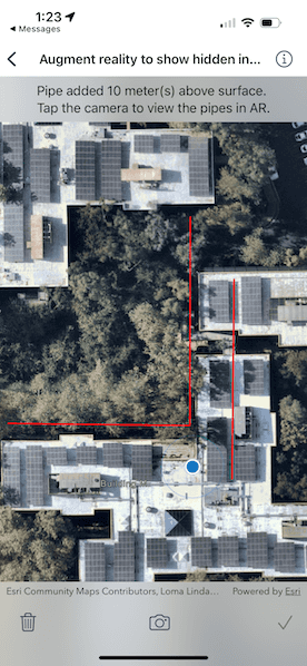
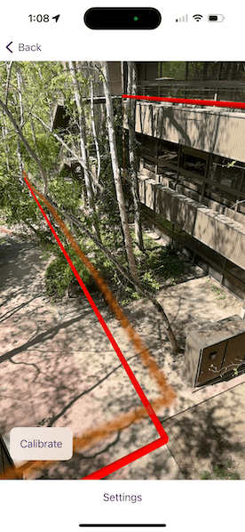
Visualize hidden infrastructure in its real-world location using augmented reality.


Use case
You can use AR to "x-ray" the ground to see pipes, wiring, or other infrastructure that isn't otherwise visible. For example, you could use this feature to trace the flow of water through a building to help identify the source of a leak.
How to use the sample
When you open the sample, you'll see a map centered on your current location. Tap on the map to draw pipes around your location. After drawing the pipes, input an elevation value to place the drawn infrastructure above or below ground. When you are ready, tap the camera button to view the infrastructure you drew in AR.
How it works
- Draw pipes on the map. See the "Create and edit geometries" sample to learn how to use the geometry editor for creating graphics.
- When you start the AR visualization experience, create and show the
WorldScaleSceneView. - Pass a
SceneViewinto the world scale scene view and set the space effecttransparentand the atmosphere effect tooff. - Create an
ArcGISTiledElevationSourceand add it to the scene's base surface. Set the navigation constraint tounconstrainedto allow going underground if needed. - Configure a graphics overlay and renderer for showing the drawn pipes. This sample uses a
SolidStrokeSymbolLayerwith aMultilayerPolylineSymbolto draw the pipes as tubes. Add the drawn pipes to the overlay.
Relevant API
- GeometryEditor
- GraphicsOverlay
- MultilayerPolylineSymbol
- SolidStrokeSymbolLayer
- Surface
- WorldScaleSceneView
About the data
This sample uses Esri's world elevation service to ensure that the infrastructure you create is accurately placed beneath the ground.
Real-scale AR relies on having data in real-world locations near the user. It isn't practical to provide pre-made data like other ArcGIS Maps SDKs for Native Apps samples, so you must draw your own nearby sample "pipe infrastructure" prior to starting the AR experience.
Additional information
Note that unlike other scene samples, a basemap isn't shown most of the time, because the real world provides the context. Only while calibrating is the basemap displayed at 50% opacity, to give the user a visual reference to compare to.
You may notice that pipes you draw underground appear to float more than you would expect. That floating is a normal result of the parallax effect that looks unnatural because you're not used to being able to see underground/obscured objects. Compare the behavior of underground pipes with equivalent pipes drawn above the surface - the behavior is the same, but probably feels more natural above ground because you see similar scenes day-to-day (e.g. utility wires).
World-scale AR is one of three main patterns for working with geographic information in augmented reality. Augmented reality is made possible with the ArcGIS Maps SDK Toolkit. See Augmented reality in the guide for more information about augmented reality and adding it to your app.
Tags
augmented reality, full-scale, infrastructure, lines, mixed reality, pipes, real-scale, underground, visualization, visualize, world-scale
Sample Code
// Copyright 2024 Esri
//
// Licensed under the Apache License, Version 2.0 (the "License");
// you may not use this file except in compliance with the License.
// You may obtain a copy of the License at
//
// https://www.apache.org/licenses/LICENSE-2.0
//
// Unless required by applicable law or agreed to in writing, software
// distributed under the License is distributed on an "AS IS" BASIS,
// WITHOUT WARRANTIES OR CONDITIONS OF ANY KIND, either express or implied.
// See the License for the specific language governing permissions and
// limitations under the License.
import ArcGIS
import CoreLocation
import SwiftUI
@available(macCatalyst, unavailable)
struct AugmentRealityToShowHiddenInfrastructureView: View {
/// The view model for the map view in the sample.
@StateObject private var model = MapModel()
/// The status message in the overlay.
@State private var statusMessage = "Tap the map to add pipe points."
/// A Boolean value indicating whether there are graphics to be deleted.
@State private var canDelete = false
/// A Boolean value indicating whether the current geometry edits can be added as a pipe.
@State private var canApplyEdits = false
/// A Boolean value indicating whether the geometry editor can undo.
@State private var geometryEditorCanUndo = false
/// A Boolean value indicating whether the alert for entering an elevation offset is showing.
@State private var elevationAlertIsPresented = false
/// The error shown in the error alert.
@State private var error: Error?
var body: some View {
MapView(map: model.map, graphicsOverlays: [model.pipesGraphicsOverlay])
.locationDisplay(model.locationDisplay)
.geometryEditor(model.geometryEditor)
.toolbar {
ToolbarItemGroup(placement: .bottomBar) {
toolbarButtons
}
}
.overlay(alignment: .top) {
instructionText
}
.elevationOffsetAlert(isPresented: $elevationAlertIsPresented) { elevationOffset in
model.addPipe(elevationOffset: elevationOffset)
canDelete = true
if elevationOffset < 0 {
statusMessage = "Pipe added \(elevationOffset.formatted()) meter(s) below surface."
} else if elevationOffset.isZero {
statusMessage = "Pipe added at ground level."
} else {
statusMessage = "Pipe added \(elevationOffset.formatted()) meter(s) above surface."
}
statusMessage.append("\nTap the camera to view the pipe(s) in AR.")
model.geometryEditor.start(withType: Polyline.self)
}
.task {
do {
try await model.startLocationDisplay()
} catch {
self.error = error
}
// Start the geometry editor and listen for its geometry updates.
model.geometryEditor.start(withType: Polyline.self)
for await geometry in model.geometryEditor.$geometry {
let polyline = geometry as? Polyline
canApplyEdits = polyline?.parts.contains { $0.points.count >= 2 } ?? false
if canApplyEdits {
statusMessage = "Tap the check mark to add the pipe."
}
geometryEditorCanUndo = model.geometryEditor.canUndo
}
}
.errorAlert(presentingError: $error)
}
/// The buttons in the bottom toolbar.
@ViewBuilder private var toolbarButtons: some View {
Button {
if geometryEditorCanUndo {
model.geometryEditor.undo()
} else {
model.removeAllGraphics()
canDelete = false
statusMessage = "Tap the map to add pipe points."
}
} label: {
Image(systemName: geometryEditorCanUndo ? "arrow.uturn.backward" : "trash")
}
.disabled(!geometryEditorCanUndo && !canDelete)
Spacer()
NavigationLink {
ARPipesSceneView(model: model.sceneModel)
} label: {
Image(systemName: "camera")
}
.disabled(geometryEditorCanUndo || !canDelete)
Spacer()
Button("Done", systemImage: "checkmark") {
elevationAlertIsPresented = true
}
.disabled(!canApplyEdits)
}
/// The instruction text in the overlay.
private var instructionText: some View {
Text(statusMessage)
.multilineTextAlignment(.center)
.frame(maxWidth: .infinity, alignment: .center)
.padding(8)
.background(.thinMaterial, ignoresSafeAreaEdges: .horizontal)
}
}
@available(macCatalyst, unavailable)
private extension AugmentRealityToShowHiddenInfrastructureView {
// MARK: Map Model
/// The view model for the map view in the sample.
@MainActor
class MapModel: ObservableObject {
/// A map with an imagery basemap style.
let map = Map(basemapStyle: .arcGISImagery)
/// The graphics overlay for the 2D pipe graphics.
let pipesGraphicsOverlay: GraphicsOverlay = {
let graphicsOverlay = GraphicsOverlay()
let redLineSymbol = SimpleLineSymbol(style: .solid, color: .red, width: 2)
graphicsOverlay.renderer = SimpleRenderer(symbol: redLineSymbol)
return graphicsOverlay
}()
/// The location display for showing the user's current location.
let locationDisplay: LocationDisplay = {
let locationDisplay = LocationDisplay(dataSource: SystemLocationDataSource())
locationDisplay.autoPanMode = .recenter
locationDisplay.initialZoomScale = 1000
return locationDisplay
}()
/// The geometry editor for creating polylines representing pipes.
let geometryEditor = GeometryEditor()
/// The view model for scene view in the sample.
let sceneModel = SceneModel()
/// Starts the location display to show user's location on the map.
func startLocationDisplay() async throws {
// Request location permission if it has not yet been determined.
let locationManager = CLLocationManager()
if locationManager.authorizationStatus == .notDetermined {
locationManager.requestWhenInUseAuthorization()
}
// Start the location display to zoom to the user's current location.
try await locationDisplay.dataSource.start()
}
/// Adds pipe graphics to the map and scene using the current geometry editor edits.
/// - Parameter elevationOffset: The elevation to offset the pipe with in the scene.
func addPipe(elevationOffset: Double) {
guard let polyline = geometryEditor.stop() as? Polyline else { return }
let pipeGraphic = Graphic(geometry: polyline)
pipesGraphicsOverlay.addGraphic(pipeGraphic)
Task {
await sceneModel.addGraphics(for: polyline, elevationOffset: elevationOffset)
}
}
/// Removes the graphics from the map and scene graphics overlays.
func removeAllGraphics() {
pipesGraphicsOverlay.removeAllGraphics()
sceneModel.pipeGraphicsOverlay.removeAllGraphics()
sceneModel.shadowGraphicsOverlay.removeAllGraphics()
sceneModel.leaderGraphicsOverlay.removeAllGraphics()
}
}
// MARK: Elevation Alert
/// An alert that allows the user to enter an elevation offset for a pipe.
struct ElevationOffsetAlert: ViewModifier {
/// A binding to a Boolean value that determines whether to present the alert.
@Binding var isPresented: Bool
/// The action to perform when the user presses "Done".
let action: (Double) -> Void
/// The text in the text field.
@State private var text = ""
/// A Boolean value indicating whether the invalid elevation alert is showing.
@State private var invalidAlertIsPresented = false
func body(content: Content) -> some View {
content
.alert("Enter an Elevation", isPresented: $isPresented) {
TextField("Enter elevation", text: $text)
.keyboardType(.numbersAndPunctuation)
Button("Cancel", role: .cancel, action: {})
Button("Done") {
if let elevationOffset = Double(text),
-10...10 ~= elevationOffset {
action(elevationOffset)
text.removeAll()
} else {
invalidAlertIsPresented = true
}
}
} message: {
Text("Enter a pipe elevation offset in meters between -10 and 10.")
}
.alert("Invalid Elevation", isPresented: $invalidAlertIsPresented) {
Button("OK") {
isPresented = true
}
} message: {
Text("\"\(text)\" is not a valid elevation offset.\nEnter a value between -10 and 10.")
}
}
}
}
@available(macCatalyst, unavailable)
private extension View {
/// Presents an alert that allows the user to enter an elevation offset for a pipe.
/// - Parameters:
/// - isPresented: A binding to a Boolean value that determines whether to present the alert.
/// - action: The action to perform when the user presses "Done".
/// - Returns: A new `View`.
func elevationOffsetAlert(
isPresented: Binding<Bool>,
action: @escaping (Double) -> Void
) -> some View {
self.modifier(
AugmentRealityToShowHiddenInfrastructureView.ElevationOffsetAlert(
isPresented: isPresented,
action: action
)
)
}
}