Use the Geometry Editor to create new point, multipoint, polyline, or polygon geometries or to edit existing geometries by interacting with a map view.
Use case
A field worker can mark features of interest on a map using an appropriate geometry. Features such as sample or observation locations, fences or pipelines, and building footprints can be digitized using point, multipoint, polyline, and polygon geometry types. Polyline and polygon geometries can be created and edited using a vertex-based creation and editing tool (i.e. vertex locations specified explicitly via tapping), or using a freehand tool.
How to use the sample
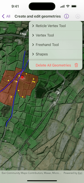
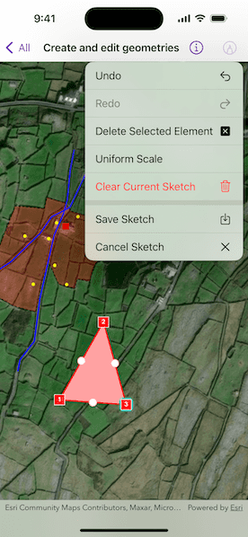
Tap the pencil button to choose a geometry editor tool. Begin interactively sketching on the map view. Tap the pencil button again for editing options.
When using the reticle vertex tool, you can move the map position of the reticle by dragging and zooming the map. Insert a vertex under the reticle by tapping on the map. Move a vertex by tapping when the reticle is located over a vertex, drag the map to move the position of the reticle, then tap a second time to place the vertex.
How it works
- Create a
GeometryEditorand assign it to a map view with thegeometryEditorview modifier. - Set the tool of the geometry editor to the preferred tool.
- Use the
start(withType:)method on theGeometryEditorto start interactively sketching on the map view. - Use various methods and properties of the
GeometryEditorto undo, redo, delete a selected element, clear the sketch, and cancel the sketch. - Edit a tool's
InteractionConfigurationto set theGeometryEditorScaleModeto allow either uniform or stretch scale mode. - Save a sketch as a
Graphicto aGraphicsOverlaydisplayed on the map view.
Relevant API
- Geometry
- GeometryBuilder
- GeometryEditor
- Graphic
- GraphicsOverlay
- MapView
Additional information
The sample opens with the ArcGIS Imagery basemap centered on the island of Inis Meáin (Aran Islands) in Ireland. Inis Meáin comprises a landscape of interlinked stone walls, roads, buildings, archaeological sites, and geological features, producing complex geometrical relationships.
Tags
draw, edit, freehand, geometry editor, sketch, vertex
Sample Code
// Copyright 2023 Esri
//
// Licensed under the Apache License, Version 2.0 (the "License");
// you may not use this file except in compliance with the License.
// You may obtain a copy of the License at
//
// https://www.apache.org/licenses/LICENSE-2.0
//
// Unless required by applicable law or agreed to in writing, software
// distributed under the License is distributed on an "AS IS" BASIS,
// WITHOUT WARRANTIES OR CONDITIONS OF ANY KIND, either express or implied.
// See the License for the specific language governing permissions and
// limitations under the License.
import ArcGIS
import SwiftUI
/// A view that shows how to interact with the geometry editor.
struct CreateAndEditGeometriesView: View {
/// A map with an imagery basemap.
@State private var map: Map = {
let map = Map(basemapStyle: .arcGISImagery)
// A viewpoint centered at the island of Inis Meáin (Aran Islands) in Ireland.
map.initialViewpoint = Viewpoint(
center: Point(latitude: 53.08230, longitude: -9.5920),
scale: 5_000
)
return map
}()
/// The view model for this sample.
@StateObject private var model = GeometryEditorModel()
/// The screen point to perform an identify operation.
@State private var identifyScreenPoint: CGPoint?
var body: some View {
VStack {
MapViewReader { proxy in
MapView(map: map, graphicsOverlays: [model.geometryOverlay])
.geometryEditor(model.geometryEditor)
.onSingleTapGesture { screenPoint, _ in
identifyScreenPoint = screenPoint
}
.task(id: identifyScreenPoint) {
guard let identifyScreenPoint,
let identifyResult = try? await proxy.identify(
on: model.geometryOverlay,
screenPoint: identifyScreenPoint,
tolerance: 5
),
let graphic = identifyResult.graphics.first,
!model.isStarted else { return }
model.startEditing(with: graphic)
}
}
}
.toolbar {
ToolbarItem(placement: .primaryAction) {
GeometryEditorMenu(model: model)
}
}
}
}
/// A view that provides a menu for geometry editor functionality.
private struct GeometryEditorMenu: View {
/// The model for the menu.
@ObservedObject var model: GeometryEditorModel
/// The currently selected element.
@State private var selectedElement: GeometryEditorElement?
/// The current geometry of the geometry editor.
@State private var geometry: Geometry?
var body: some View {
Menu {
if !model.isStarted {
// If the geometry editor is not started, show the main menu.
mainMenuContent
} else {
// If the geometry editor is started, show the edit menu.
editMenuContent
.task {
for await geometry in model.geometryEditor.$geometry {
// Update geometry when there is an update.
self.geometry = geometry
}
}
.task {
for await element in model.geometryEditor.$selectedElement {
// Update selected element when there is an update.
selectedElement = element
}
}
}
} label: {
Label("Geometry Editor", systemImage: "pencil.tip.crop.circle")
}
}
}
private extension GeometryEditorMenu {
/// The content of the main menu.
var mainMenuContent: some View {
VStack {
Menu("Reticle Vertex Tool") {
Button {
model.startEditing(with: ReticleVertexTool(), geometryType: Point.self)
} label: {
Label("New Point", systemImage: "smallcircle.filled.circle")
}
Button {
model.startEditing(with: ReticleVertexTool(), geometryType: Polyline.self)
} label: {
Label("New Line", systemImage: "line.diagonal")
}
Button {
model.startEditing(with: ReticleVertexTool(), geometryType: Polygon.self)
} label: {
Label("New Area", systemImage: "skew")
}
Button {
model.startEditing(with: ReticleVertexTool(), geometryType: Multipoint.self)
} label: {
Label("New Multipoint", systemImage: "hand.point.up.braille")
}
}
Menu("Vertex Tool") {
Button {
model.startEditing(with: VertexTool(), geometryType: Point.self)
} label: {
Label("New Point", systemImage: "smallcircle.filled.circle")
}
Button {
model.startEditing(with: VertexTool(), geometryType: Polyline.self)
} label: {
Label("New Line", systemImage: "line.diagonal")
}
Button {
model.startEditing(with: VertexTool(), geometryType: Polygon.self)
} label: {
Label("New Area", systemImage: "skew")
}
Button {
model.startEditing(with: VertexTool(), geometryType: Multipoint.self)
} label: {
Label("New Multipoint", systemImage: "hand.point.up.braille")
}
}
Menu("Freehand Tool") {
Button {
model.startEditing(with: FreehandTool(), geometryType: Polyline.self)
} label: {
Label("New Freehand Line", systemImage: "scribble")
}
Button {
model.startEditing(with: FreehandTool(), geometryType: Polygon.self)
} label: {
Label("New Freehand Area", systemImage: "lasso")
}
}
Menu("Shapes") {
Button {
model.startEditing(with: ShapeTool(kind: .arrow), geometryType: Polyline.self)
} label: {
Label("New Line Arrow", systemImage: "arrowshape.right")
}
Button {
model.startEditing(with: ShapeTool(kind: .arrow), geometryType: Polygon.self)
} label: {
Label("New Polygon Arrow", systemImage: "arrowshape.right.fill")
}
Button {
model.startEditing(with: ShapeTool(kind: .rectangle), geometryType: Polyline.self)
} label: {
Label("New Line Rectangle", systemImage: "rectangle")
}
Button {
model.startEditing(with: ShapeTool(kind: .rectangle), geometryType: Polygon.self)
} label: {
Label("New Polygon Rectangle", systemImage: "rectangle.fill")
}
Button {
model.startEditing(with: ShapeTool(kind: .ellipse), geometryType: Polyline.self)
} label: {
Label("New Line Ellipse", systemImage: "circle")
}
Button {
model.startEditing(with: ShapeTool(kind: .ellipse), geometryType: Polygon.self)
} label: {
Label("New Polygon Ellipse", systemImage: "circle.fill")
}
Button {
model.startEditing(with: ShapeTool(kind: .triangle), geometryType: Polyline.self)
} label: {
Label("New Line Triangle", systemImage: "triangle")
}
Button {
model.startEditing(with: ShapeTool(kind: .triangle), geometryType: Polygon.self)
} label: {
Label("New Polygon Triangle", systemImage: "triangle.fill")
}
}
Divider()
Button(role: .destructive) {
model.deleteAllGeometries()
} label: {
Label("Delete All Geometries", systemImage: "trash")
}
.disabled(!model.canClearGraphics)
}
}
/// The content of the editing menu.
var editMenuContent: some View {
VStack {
Button {
model.geometryEditor.undo()
} label: {
Label("Undo", systemImage: "arrow.uturn.backward")
}
.disabled(!canUndo)
Button {
model.geometryEditor.redo()
} label: {
Label("Redo", systemImage: "arrow.uturn.forward")
}
.disabled(!canRedo)
Button {
model.geometryEditor.deleteSelectedElement()
} label: {
Label("Delete Selected Element", systemImage: "xmark.square.fill")
}
.disabled(deleteButtonIsDisabled)
Toggle("Uniform Scale", isOn: $model.isUniformScale)
Button(role: .destructive) {
model.geometryEditor.clearGeometry()
} label: {
Label("Clear Current Sketch", systemImage: "trash")
}
.disabled(!canClearCurrentSketch)
Divider()
Button {
model.save()
} label: {
Label("Save Sketch", systemImage: "square.and.arrow.down")
}
.disabled(!canSave)
Button {
model.stop()
} label: {
Label("Cancel Sketch", systemImage: "xmark")
}
}
}
}
private extension GeometryEditorMenu {
/// A Boolean value indicating whether the selection can be deleted.
///
/// In some instances deleting the selection may be invalid. One example would be the mid vertex
/// of a line.
var deleteButtonIsDisabled: Bool {
guard let selectedElement else { return true }
return !selectedElement.canBeDeleted
}
/// A Boolean value indicating if the geometry editor can perform an undo.
var canUndo: Bool {
return model.geometryEditor.canUndo
}
/// A Boolean value indicating if the geometry editor can perform a redo.
var canRedo: Bool {
return model.geometryEditor.canRedo
}
/// A Boolean value indicating if the geometry can be saved to a graphics overlay.
var canSave: Bool {
return geometry?.sketchIsValid ?? false
}
/// A Boolean value indicating if the geometry can be cleared from the geometry editor.
var canClearCurrentSketch: Bool {
return geometry.map { !$0.isEmpty } ?? false
}
}
/// An object that acts as a view model for the geometry editor menu.
@MainActor
private class GeometryEditorModel: ObservableObject {
/// The geometry editor.
let geometryEditor = GeometryEditor()
/// The graphics overlay used to save geometries to.
let geometryOverlay = GraphicsOverlay(renderingMode: .dynamic)
/// A Boolean value indicating if the initial graphics and saved sketches can be cleared.
@Published private(set) var canClearGraphics = false
/// A Boolean value indicating if the geometry editor has started.
@Published private(set) var isStarted = false
/// A Boolean value indicating if the scale mode is uniform.
@Published var isUniformScale = false {
didSet {
configureGeometryEditorTool(geometryEditor.tool, scaleMode: scaleMode)
}
}
/// The scale mode to be set on the geometry editor.
private var scaleMode: GeometryEditorScaleMode {
isUniformScale ? .uniform : .stretch
}
/// The selected graphic to edit.
private var selectedGraphic: Graphic?
init() {
let boundaryGraphic = Graphic(geometry: .boundary(), symbol: .polygon)
let road1Graphic = Graphic(geometry: .road1(), symbol: .polyline)
let road2Graphic = Graphic(geometry: .road2(), symbol: .polyline)
let outbuildingsGraphic = Graphic(geometry: .outbuildings(), symbol: .multipoint)
let houseGraphic = Graphic(geometry: .house(), symbol: .point)
geometryOverlay.addGraphics([
boundaryGraphic,
road1Graphic,
road2Graphic,
outbuildingsGraphic,
houseGraphic
])
canClearGraphics = true
}
/// Saves the current geometry to the graphics overlay and stops editing.
/// - Precondition: Geometry's sketch must be valid.
func save() {
precondition(geometryEditor.geometry?.sketchIsValid ?? false)
if selectedGraphic != nil {
// Update geometry for edited graphic.
updateGraphic()
} else {
// Add new graphic.
addGraphic()
}
}
/// Updates the selected graphic with the current geometry.
private func updateGraphic() {
guard let selectedGraphic else { return }
selectedGraphic.geometry = geometryEditor.stop()
isStarted = false
selectedGraphic.isVisible = true
self.selectedGraphic = nil
}
/// Adds a new graphic for the current geometry to the graphics overlay.
private func addGraphic() {
let geometry = geometryEditor.geometry!
let graphic = Graphic(geometry: geometry, symbol: symbol(for: geometry))
geometryOverlay.addGraphic(graphic)
stop()
canClearGraphics = true
}
/// Removes the initial graphics and saved sketches on the graphics overlay.
func deleteAllGeometries() {
geometryOverlay.removeAllGraphics()
canClearGraphics = false
}
/// Stops editing with the geometry editor.
func stop() {
geometryEditor.stop()
isStarted = false
selectedGraphic?.isVisible = true
selectedGraphic = nil
}
/// Returns the symbology for graphics saved to the graphics overlay.
/// - Parameter geometry: The geometry of the graphic to be saved.
/// - Returns: Either a marker or fill symbol depending on the type of provided geometry.
private func symbol(for geometry: Geometry) -> Symbol {
switch geometry {
case is Point:
return .point
case is Multipoint:
return .multipoint
case is Polyline:
return .polyline
case is ArcGIS.Polygon:
return .polygon
default:
fatalError("Unexpected geometry type")
}
}
/// Configures the scale mode for the geometry editor tool.
/// - Parameters:
/// - tool: The geometry editor tool.
/// - scaleMode: Preserve the original aspect ratio or scale freely.
private func configureGeometryEditorTool(_ tool: GeometryEditorTool, scaleMode: GeometryEditorScaleMode) {
switch tool {
case let tool as FreehandTool:
tool.configuration.scaleMode = scaleMode
case let tool as ShapeTool:
tool.configuration.scaleMode = scaleMode
case let tool as VertexTool:
tool.configuration.scaleMode = scaleMode
case _ as ReticleVertexTool:
break
default:
fatalError("Unexpected tool type")
}
}
/// Starts editing with the specified tool and geometry type.
/// - Parameters:
/// - tool: The tool to draw with.
/// - geometryType: The type of geometry to draw.
func startEditing(with tool: GeometryEditorTool, geometryType: Geometry.Type) {
configureGeometryEditorTool(tool, scaleMode: scaleMode)
geometryEditor.tool = tool
geometryEditor.start(withType: geometryType)
isStarted = true
}
/// Starts editing a given graphic with the geometry editor.
/// - Parameter graphic: The graphic to edit.
func startEditing(with graphic: Graphic) {
selectedGraphic = graphic
graphic.isVisible = false
let geometry = graphic.geometry!
switch geometry {
case is Point, is Multipoint:
geometryEditor.tool = VertexTool()
default:
break
}
geometryEditor.start(withInitial: geometry)
isStarted = true
}
}
private extension Geometry {
// swiftlint:disable force_try
static func house() -> Point {
let jsonStr = """
{"x":-1067898.59,
"y":6998366.62,
"spatialReference":{"latestWkid":3857,"wkid":102100}}
"""
return try! Point.fromJSON(jsonStr)
}
static func road1() -> Polyline {
let jsonStr = """
{"paths":[[[-1068095.40,6998123.52],[-1068086.16,6998134.60],
[-1068083.20,6998160.44],[-1068104.27,6998205.37],
[-1068070.63,6998255.22],[-1068014.44,6998291.54],
[-1067952.33,6998351.85],[-1067927.93,6998386.93],
[-1067907.97,6998396.78],[-1067889.86,6998406.63],
[-1067848.08,6998495.26],[-1067832.92,6998521.11]]],
"spatialReference":{"latestWkid":3857,"wkid":102100}}
"""
return try! Polyline.fromJSON(jsonStr)
}
static func road2() -> Polyline {
let jsonStr = """
{"paths":[[[-1067999.28,6998061.97],[-1067994.48,6998086.59],
[-1067964.53,6998125.37],[-1067952.70,6998215.84],
[-1067923.13,6998347.54],[-1067903.90,6998391.86],
[-1067895.40,6998422.02],[-1067891.70,6998460.18],
[-1067889.49,6998483.56],[-1067880.98,6998527.26]]],
"spatialReference":{"latestWkid":3857,"wkid":102100}}
"""
return try! Polyline.fromJSON(jsonStr)
}
static func outbuildings() -> Multipoint {
let jsonStr = """
{"points":[[-1067984.26,6998346.28],[-1067966.80,6998244.84],
[-1067921.88,6998284.65],[-1067934.36,6998340.74],
[-1067917.93,6998373.97],[-1067828.30,6998355.28],
[-1067832.25,6998339.70],[-1067823.10,6998336.93],
[-1067873.22,6998386.78],[-1067896.72,6998244.49]],
"spatialReference":{"latestWkid":3857,"wkid":102100}}
"""
return try! Multipoint.fromJSON(jsonStr)
}
static func boundary() -> ArcGIS.Polygon {
let jsonStr = """
{"rings":[[[-1067943.67,6998403.86],[-1067938.17,6998427.60],
[-1067898.77,6998415.86],[-1067888.26,6998398.80],
[-1067800.85,6998372.93],[-1067799.61,6998342.81],
[-1067809.38,6998330.00],[-1067817.07,6998307.85],
[-1067838.07,6998285.34],[-1067849.10,6998250.38],
[-1067874.02,6998256.00],[-1067879.87,6998235.95],
[-1067913.41,6998245.03],[-1067934.84,6998291.34],
[-1067948.41,6998251.90],[-1067961.18,6998186.68],
[-1068008.59,6998199.49],[-1068052.89,6998225.45],
[-1068039.37,6998261.11],[-1068064.12,6998265.26],
[-1068043.32,6998299.88],[-1068036.25,6998327.93],
[-1068004.43,6998409.28],[-1067943.67,6998403.86]]],
"spatialReference":{"latestWkid":3857,"wkid":102100}}
"""
return try! Polygon.fromJSON(jsonStr)
}
// swiftlint:enable force_try
}
private extension Symbol {
static var point: SimpleMarkerSymbol {
SimpleMarkerSymbol(
style: .square,
color: .red,
size: 10
)
}
static var multipoint: SimpleMarkerSymbol {
SimpleMarkerSymbol(
style: .circle,
color: .yellow,
size: 5
)
}
static var polyline: SimpleLineSymbol {
SimpleLineSymbol(
color: .blue,
width: 2
)
}
static var polygon: SimpleFillSymbol {
SimpleFillSymbol(
style: .solid,
color: .red.withAlphaComponent(0.3),
outline: SimpleLineSymbol(
style: .dash,
color: .black,
width: 1
)
)
}
}
#Preview {
NavigationStack {
CreateAndEditGeometriesView()
}
}