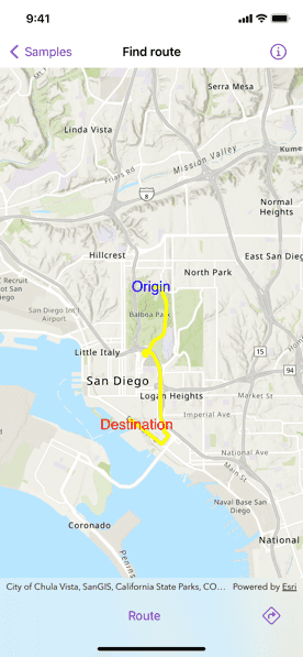
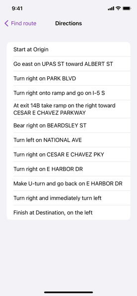
Display directions for a route between two points.


Use case
Find routes with driving directions between any number of locations. You might use the ArcGIS platform to create a custom network for routing on private roads.
How to use the sample
For simplicity, the sample comes loaded with a start and end stop. You can click on the Find Route button to display a route between these stops. Once the route is generated, tap the directions icon for turn-by-turn directions shown in a list.
How it works
- Create a
RouteTaskinstance using a URL to an online route service. - Create default
RouteParametersusingRouteTask.createDefaultParameters(). - Set
returnDirectionson the parameters totrue. - Create
Stopinstances for each destination and assign the stops to the route parameters usingRouteParameters.setStops(_:). - Solve the route using
RouteTask.solveRoute(routeParameters:)to get aRouteResult. - Create
GraphicsOverlayandGraphicinstances for the route and stops. - Iterate through the result's
Routes. To display the route, update the route graphic's geometry with the route'srouteGeometry. To display directions, get the direction maneuvers from the route'sdirectionManeuversproperty, and, for each maneuver, display the maneuver'sdirectionText.
Relevant API
- DirectionManeuver
- Route
- RouteParameters
- RouteParameters.setStops(_:)
- RouteResult
- RouteTask
- RouteTask.createDefaultParameters()
- RouteTask.solveRoute(routeParameters:)
- Stop
Tags
directions, driving, navigation, network, network analysis, route, routing, shortest path, turn-by-turn
Sample Code
// Copyright 2022 Esri
//
// Licensed under the Apache License, Version 2.0 (the "License");
// you may not use this file except in compliance with the License.
// You may obtain a copy of the License at
//
// https://www.apache.org/licenses/LICENSE-2.0
//
// Unless required by applicable law or agreed to in writing, software
// distributed under the License is distributed on an "AS IS" BASIS,
// WITHOUT WARRANTIES OR CONDITIONS OF ANY KIND, either express or implied.
// See the License for the specific language governing permissions and
// limitations under the License.
import ArcGIS
import SwiftUI
struct FindRouteView: View {
/// The error shown in the error alert.
@State private var error: Error?
/// A Boolean value indicating whether to show the directions.
@State private var isShowingDirections = false
/// A Boolean value indicating whether to solve the route.
@State private var isSolvingRoute = false
/// The view model for this sample.
@StateObject private var model = Model()
var body: some View {
MapView(map: model.map, graphicsOverlays: model.graphicsOverlays)
.errorAlert(presentingError: $error)
.task {
do {
try await model.initializeRouteParameters()
} catch {
self.error = error
}
}
.toolbar {
ToolbarItemGroup(placement: .bottomBar) {
Spacer()
Button("Route") {
isSolvingRoute = true
}
.disabled(model.isRouteDisabled || isSolvingRoute)
.task(id: isSolvingRoute) {
// Ensures that solving the route is true.
guard isSolvingRoute else { return }
// Finds the route.
do {
try await model.findRoute()
} catch {
self.error = error
}
// Sets solving the route to false.
isSolvingRoute = false
}
Spacer()
Button {
isShowingDirections = true
} label: {
Image(systemName: "arrow.triangle.turn.up.right.diamond")
}
.disabled(model.directions.isEmpty)
.popover(isPresented: $isShowingDirections) {
NavigationStack {
List(model.directions, id: \.text) { directionManeuver in
Text(directionManeuver.text)
}
.navigationTitle("Directions")
.navigationBarTitleDisplayMode(.inline)
.toolbar {
ToolbarItem(placement: .confirmationAction) {
Button("Done") {
isShowingDirections = false
}
}
}
}
.frame(idealWidth: 320, idealHeight: 428)
}
}
}
}
}
private extension FindRouteView {
/// The model used to store the geo model and other expensive objects
/// used in this view.
@MainActor
class Model: ObservableObject {
/// The directions for the route.
@Published var directions: [DirectionManeuver] = []
/// The parameters for the route.
@Published var routeParameters: RouteParameters!
/// A Boolean value indicating whether to disable the route button.
var isRouteDisabled: Bool { routeParameters == nil }
/// The route task.
private let routeTask = RouteTask(url: .routeTask)
/// A map with a topographic basemap style and an initial viewpoint.
let map: Map
/// The stops for the route.
private let stops: [Stop]
/// The graphics overlay for the route.
private let routeGraphicsOverlay: GraphicsOverlay
/// The graphics overlay for the stops.
private let stopGraphicsOverlay: GraphicsOverlay
/// The graphics overlays for the route and stops.
var graphicsOverlays: [GraphicsOverlay] { [routeGraphicsOverlay, stopGraphicsOverlay] }
/// The graphic for the route.
private var routeGraphic: Graphic { routeGraphicsOverlay.graphics.first! }
init() {
// Initializes the map
map = Map(basemapStyle: .arcGISTopographic)
map.initialViewpoint = Viewpoint(
center: Point(
x: -13041154.7153,
y: 3858170.2368,
spatialReference: .webMercator
),
scale: 1e5
)
// Initializes the graphics overlay for the route.
routeGraphicsOverlay = GraphicsOverlay(graphics: [
Graphic(symbol: SimpleLineSymbol(style: .solid, color: .yellow, width: 5))
])
// Initializes the stops and the graphics overlay for them.
let stopOne = Stop.one
let stopTwo = Stop.two
stops = [stopOne, stopTwo]
let stopOneGraphic = Graphic(
geometry: stopOne.geometry,
symbol: TextSymbol(text: stopOne.name, color: .blue, size: 20)
)
let stopTwoGraphic = Graphic(
geometry: stopTwo.geometry,
symbol: TextSymbol(text: stopTwo.name, color: .red, size: 20)
)
stopGraphicsOverlay = GraphicsOverlay(graphics: [stopOneGraphic, stopTwoGraphic])
}
/// Initializes the route parameters.
func initializeRouteParameters() async throws {
guard routeParameters == nil else { return }
// Creates the default parameters.
let parameters = try await routeTask.makeDefaultParameters()
// Sets the return directions on the parameters to true.
parameters.returnsDirections = true
// Sets the stops for the route.
parameters.setStops(stops)
// Initializes the route parameters.
routeParameters = parameters
}
/// Finds the route from stop one to stop two.
func findRoute() async throws {
// Resets the route geometry and directions.
routeGraphic.geometry = nil
directions.removeAll()
// Solves the route based on the route parameters.
let routeResult = try await routeTask.solveRoute(using: routeParameters)
if let firstRoute = routeResult.routes.first {
// Updates the route geometry and directions.
routeGraphic.geometry = firstRoute.geometry
directions = firstRoute.directionManeuvers
}
}
}
}
private extension Stop {
/// The stop for the origin.
static var one: Stop {
let stop = Stop(point: Point(x: -13041171.537945, y: 3860988.271378, spatialReference: .webMercator))
stop.name = "Origin"
return stop
}
/// The stop for the destination.
static var two: Stop {
let stop = Stop(point: Point(x: -13041693.562570, y: 3856006.859684, spatialReference: .webMercator))
stop.name = "Destination"
return stop
}
}
private extension URL {
/// The URL for the route task.
static var routeTask: URL {
URL(string: "https://sampleserver6.arcgisonline.com/arcgis/rest/services/NetworkAnalysis/SanDiego/NAServer/Route")!
}
}
#Preview {
NavigationStack {
FindRouteView()
}
}