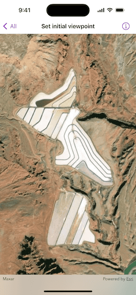
Display the map at an initial viewpoint representing a bounding geometry.

Use case
Setting the initial viewpoint is useful when a user wishes to first load the map at a particular area of interest.
How to use the sample
When the sample loads, note the map is opened at the initial viewpoint that is set to it.
How it works
- Instantiate a
Mapobject. - Instantiate a
Viewpointobject using anEnvelopeobject. - Set the starting location of the map with
map.initialViewpoint = Viewpoint(boundingGeometry:). - Set the map to a
MapViewobject.
Relevant API
- Envelope
- Map
- MapView
- Point
- Viewpoint
Tags
envelope, extent, initial viewpoint, zoom
Sample Code
SetInitialViewpointView.swift
// Copyright 2024 Esri
//
// Licensed under the Apache License, Version 2.0 (the "License");
// you may not use this file except in compliance with the License.
// You may obtain a copy of the License at
//
// https://www.apache.org/licenses/LICENSE-2.0
//
// Unless required by applicable law or agreed to in writing, software
// distributed under the License is distributed on an "AS IS" BASIS,
// WITHOUT WARRANTIES OR CONDITIONS OF ANY KIND, either express or implied.
// See the License for the specific language governing permissions and
// limitations under the License.
import ArcGIS
import SwiftUI
struct SetInitialViewpointView: View {
/// A map with a basemap and an initial viewpoint.
@State private var map: Map = {
let map = Map(basemapStyle: .arcGISImageryStandard)
map.initialViewpoint = Viewpoint(boundingGeometry: .potashPonds)
return map
}()
var body: some View {
MapView(map: map)
}
}
private extension Geometry {
/// The area around Potash Ponds, Moab, Utah.
static var potashPonds: Envelope {
Envelope(
xRange: -12211308.778729 ... -12208257.879667,
yRange: 4645116.003309 ... 4650542.535773,
spatialReference: .webMercator
)
}
}
#Preview {
SetInitialViewpointView()
}