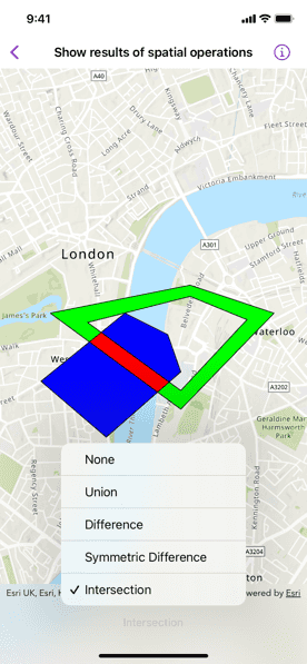
Find the union, intersection, or difference of two geometries.

Use case
The different spatial operations (union, difference, symmetric difference, and intersection) can be used for a variety of spatial analyses. For example, government authorities may use the intersect operation to determine whether a proposed road cuts through a restricted piece of land such as a nature reserve or a private property.
When these operations are chained together, they become even more powerful. An analysis of food deserts within an urban area might begin by union-ing service areas of grocery stores, farmers markets, and food co-ops. Taking the difference between this single geometry of all services areas and that of a polygon delineating a neighborhood would reveal the areas within that neighborhood where access to healthy, whole foods may not exist.
How to use the sample
The sample provides an option to select a spatial operation. When an operation is selected, the resulting geometry is shown in red.
How it works
- Create a
GraphicsOverlayobject. - Create
Graphicinstances for the overlapping polygons and result. - Add the overlapping polygons and result graphics to the graphics overlay.
- Perform spatial relationships between the polygons by using the appropriate operation:
static GeometryEngine.union(_:_:)- This method returns the two geometries united together as one geometry.static GeometryEngine.difference(_:_:)- This method returns the difference between two geometries.static GeometryEngine.symmetricDifference(_:_:)- This method returns any part of two geometries that do not intersect.static GeometryEngine.intersection(_:_:)- This method returns the intersection of two geometries.
- Use the geometry that is returned from the method call to update the geometry of the results graphic.
Relevant API
- Geometry
- GeometryEngine
- Graphic
- GraphicsOverlay
- static GeometryEngine.difference(::)
- static GeometryEngine.intersection(::)
- static GeometryEngine.symmetricDifference(::)
- static GeometryEngine.union(::)
Tags
analysis, combine, difference, geometry, intersection, merge, polygon, union
Sample Code
// Copyright 2022 Esri
//
// Licensed under the Apache License, Version 2.0 (the "License");
// you may not use this file except in compliance with the License.
// You may obtain a copy of the License at
//
// https://www.apache.org/licenses/LICENSE-2.0
//
// Unless required by applicable law or agreed to in writing, software
// distributed under the License is distributed on an "AS IS" BASIS,
// WITHOUT WARRANTIES OR CONDITIONS OF ANY KIND, either express or implied.
// See the License for the specific language governing permissions and
// limitations under the License.
import ArcGIS
import SwiftUI
struct ShowResultOfSpatialOperationsView: View {
/// The current spatial operation performed.
@State private var spatialOperation = SpatialOperation.none
/// The view model for the sample.
@StateObject private var model = Model()
var body: some View {
MapView(map: model.map, graphicsOverlays: [model.graphicsOverlay])
.onChange(of: spatialOperation) { _ in
model.performOperation(spatialOperation)
}
.toolbar {
ToolbarItem(placement: .bottomBar) {
Picker("Spatial Operation", selection: $spatialOperation) {
ForEach(SpatialOperation.allCases, id: \.self) { operation in
Text(operation.label)
}
}
}
}
}
}
private extension ShowResultOfSpatialOperationsView {
/// An enum of spatial operations.
enum SpatialOperation: CaseIterable {
case intersection, symmetricDifference, difference, union, none
/// A human-readable label for each spatial operation.
var label: String {
switch self {
case .none: return "None"
case .union: return "Union"
case .difference: return "Difference"
case .symmetricDifference: return "Symmetric Difference"
case .intersection: return "Intersection"
}
}
}
/// The model used to store the geo model and other expensive objects
/// used in this view.
class Model: ObservableObject {
/// A map with a topographic basemap style and initial viewpoint.
let map: Map = {
let map = Map(basemapStyle: .arcGISTopographic)
map.initialViewpoint = Viewpoint(
center: Point(x: -13453, y: 6710127, spatialReference: .webMercator),
scale: 30_000
)
return map
}()
/// A graphics overlay for the map view.
let graphicsOverlay: GraphicsOverlay = {
// Creates the graphics for the two polygons and result.
let polygonOneGraphic = Graphic(
geometry: .polygon1,
symbol: SimpleFillSymbol(color: .blue, outline: .simple)
)
let polygonTwoGraphic = Graphic(
geometry: .polygon2,
symbol: SimpleFillSymbol(color: .green, outline: .simple)
)
let resultGraphic = Graphic(
symbol: SimpleFillSymbol(color: .red, outline: .simple)
)
// Adds the graphics to the overlay.
return GraphicsOverlay(graphics: [polygonOneGraphic, polygonTwoGraphic, resultGraphic])
}()
/// A graphic representing the result of the spatial operation.
var resultGraphic: Graphic { graphicsOverlay.graphics.last! }
/// Updates the result graphic based on the spatial operation.
func performOperation(_ spatialOperation: SpatialOperation) {
let resultGeometry: Geometry?
// Updates the geometry based on the selected spatial operation.
switch spatialOperation {
case .none:
resultGeometry = nil
case .union:
resultGeometry = GeometryEngine.union(.polygon1, .polygon2)
case .difference:
resultGeometry = GeometryEngine.difference(.polygon1, .polygon2)
case .symmetricDifference:
resultGeometry = GeometryEngine.symmetricDifference(.polygon1, .polygon2)
case .intersection:
resultGeometry = GeometryEngine.intersection(.polygon1, .polygon2)
}
// Updates the result graphic geometry.
resultGraphic.geometry = resultGeometry
}
}
}
private extension LineSymbol {
/// A solid, thin, black line.
static var simple: LineSymbol {
SimpleLineSymbol(style: .solid, color: .black, width: 1)
}
}
private extension Geometry {
/// The geometry for polygon one.
static var polygon1: Geometry {
Polygon(
points: [
Point(x: -13960, y: 6709400),
Point(x: -14660, y: 6710000),
Point(x: -13760, y: 6710730),
Point(x: -13300, y: 6710500),
Point(x: -13160, y: 6710100)
],
spatialReference: .webMercator
)
}
/// The geometry for polygon two.
static var polygon2: Geometry {
Polygon(
parts: [
// The outer ring.
MutablePart(
points: [
Point(x: -13060, y: 6711030),
Point(x: -12160, y: 6710730),
Point(x: -13160, y: 6709700),
Point(x: -14560, y: 6710730),
Point(x: -13060, y: 6711030)
],
spatialReference: .webMercator
),
// The inner ring.
MutablePart(
points: [
Point(x: -13060, y: 6710910),
Point(x: -14160, y: 6710630),
Point(x: -13160, y: 6709900),
Point(x: -12450, y: 6710660),
Point(x: -13060, y: 6710910)
],
spatialReference: .webMercator
)
]
)
}
}
#if DEBUG
private extension ShowResultOfSpatialOperationsView.Model {
typealias SpatialOperation = ShowResultOfSpatialOperationsView.SpatialOperation
}
#Preview {
NavigationStack {
ShowResultOfSpatialOperationsView()
}
}
#endif