Mesh modifications enable you to remove areas of integrated mesh scene layers and the elevation surface. There are two different ways to remove parts of the integrated mesh layers: by hiding content inside the specified polygons (referred to as clip); or by hiding content outside the specified polygons (referred to as mask). You can add multiple mesh modifications to an ArcGIS. Once you have set up the ArcGIS with all mesh modifications you want to make, you can set it on an ArcGIS and ArcGIS.
| Illustration | Modification | Description |
|---|---|---|
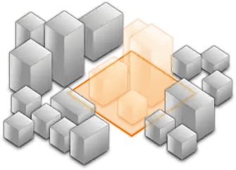
| clip - removes the specified area | Clip-out areas of integrated mesh scene layers to show other layers or actors in the area. For example, you can place custom buildings and landscapes in the area and combine with spatial data. |
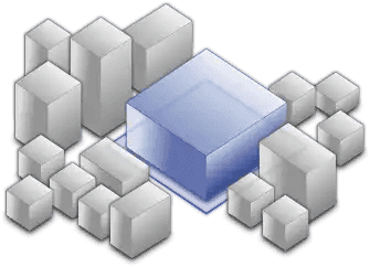
| mask - displays content only within the specified area | Define an area of interest with a polygon geometry to render only the area of the integrated mesh layer that falls within the polygon. For example, if you want to show only an area of an integrated mesh inside the boundaries of a city. |
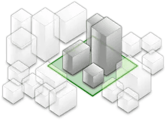
| replace - flattens the selected area | Replace an area of an integrated mesh based on a 3D polygon. For example, to add constructed buildings, flatten the integrated mesh at the footprint of a building to visualize the new building. Or save different scenarios of a new construction area as a web scene that replaces the integrated mesh at that site. Integrated mesh flattens to the minimum z-vertex of the modification polygon when the polygon is created. You can change the altitude of the area after a polygon is created. |
Polygons used to specify the area for mesh modification; must have a spatial reference that matches the spatial reference of the layer or the elevation surface. See the When you need to know about spatial references topics to find the spatial reference of your elevation surface or integrated mesh scene layers.
Apply mesh modification to layers
With the Map Creator UI, you can set mesh modifications for the elevation surface and integrated mesh scene layers. You can use the tool overlay to create polygons and set modifications.
Open the tool overlay in the Viewport
To work with mesh modifications, open the tool overlay in the Viewport.
For the elevation surface:
- Click the Elevation tab.
- Click the gear button above the elevation source list to display the tool.
For an integrated mesh scene layer:
- Click the Layers tab.
- Click the triangle button on the left to expand the integrated mesh scene layer registry and see the layer properties.
- On the Mesh Modifications raw, click the gear button to display the tool.
Configure a mesh modification
To set a mesh modification, first create a polygon, then set the modification type.
- In the tool overlay, click the
 button.
 - Click in the Viewport to draw a polygon.
- Click the
 button. (The button color will change to blue.)
 - Draw a polygon in the Viewport by dropping points with clicks.
- Select the polygon by clicking the polygon lines or anywhere inside the polygon. (The line color will change to blue.)
- Click the Clip, Mask, or Replace button to select the modification you want to apply.
- If you selected Replace, use the gizmo to set the altitude.
- Click x in the top right corner to close the tool overlay.
Edit a mesh modification
To edit a mesh modification, open the tool overlay for the elevation surface or the integrated mesh scene layer containing the modification.
-
To display polygons for the elevation surface or an integrated mesh scene layer, open the tool overlay.
-
To select a polygon, click the polygon lines or click inside the polygon while the
button is selected in the tool. (The line color changes to blue when selected.) -
To deselect a polygon, click outside of the polygon in the Viewport.
-
To move a polygon, use the gizmo while the polygon is selected.
-
To move the point position of a polygon, click a point and drag.
-
To add points to a polygon, click the middle point of a line.
-
To copy a polygon, click the
 button while the polygon is selected.
 -
To paste a polygon, click the
 button after opening the tool overlay for the elevation surface or an integrated mesh scene layer.
 -
To delete a polygon, click the
 button while the polygon is selected.
 -
To change the modification type, click another button while the polygon is selected.
-
To turn off modifications for the elevation surface or the layer, uncheck the Mesh modifications checkbox.