With different types of supported data layers on ArcGIS Online or ArcGIS Living Atlas, you can create immersive scenes of real-world cities within minutes by using the ArcGIS Maps SDK for Unreal Engine plugin. You can also leverage game engine capabilities such as sky components, water materials, and weather effects to make your scene more realistic and dynamic.
Featured data layer examples
The following examples showcase a few sets of data that can be used to set up a scene categorized by different cities across the world. To learn how to set up a level, refer to the tutorial pages.
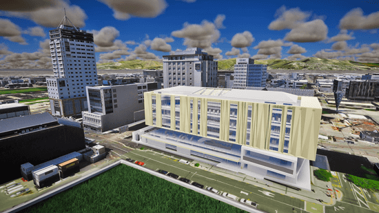
Christchurch, New Zealand
- Origin Position:
- Longitude: 172.63669613327883
- Latitude: -43.530260167108686
- Altitude: 0
- Spatial Reference WKID: 4326
- Camera Position:
- Longitude: 172.636864
- Latitude: -43.529333
- Altitude: 44.015807
- Spatial Reference WKID: 4326
- Camera Rotation:
- Heading: 149.47337
- Pitch: 78.275476
- Roll: 359.999423
- Data Layers:
-
ArcGIS Online item: ccbuildings_wgs84
-
Type:
ArcGIS 3 D Object Scene Layer -
Online service URL (source):
Use dark colors for code blocks Copy https://tiles.arcgis.com/tiles/pmcEyn9tLWCoX7Dm/arcgis/rest/services/ccbuildings_wgs84/SceneServer -
ArcGIS Online item: Turanga Library
-
Type:
ArcGIS Building Scene Layer -
Online service URL (source):
Use dark colors for code blocks Copy https://tiles.arcgis.com/tiles/cFEFS0EWrhfDeVw9/arcgis/rest/services/Turanga_Library/SceneServer
-
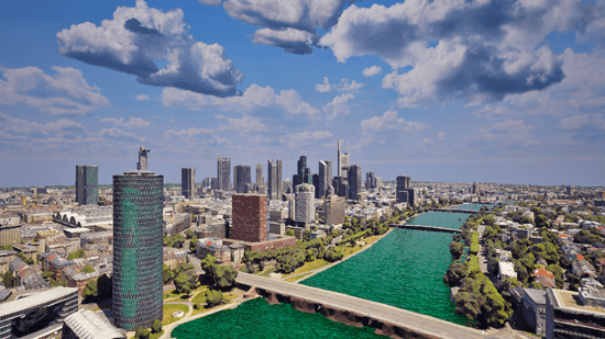
Frankfurt, Germany
- Origin Position:
- Longitude: 8.64607
- Latitude: 50.090001
- Altitude: 0
- Spatial Reference WKID: 4326
- Camera Position:
- Longitude: 8.665073
- Latitude: 50.098586
- Altitude: 203.958997
- Spatial Reference WKID: 4326
- Camera Rotation:
- Heading: 18.21456
- Pitch: 90.211967
- Roll: 0.008897
- Data Layers:
- ArcGIS Online item: Frankfurt Integrated Mesh
- Type:
ArcGIS Integrated Mesh Layer - Online service URL (source):
Use dark colors for code blocks Copy https://tiles.arcgis.com/tiles/z2tnIkrLQ2BRzr6P/arcgis/rest/services/2021_02_04_Frankfurt/SceneServer
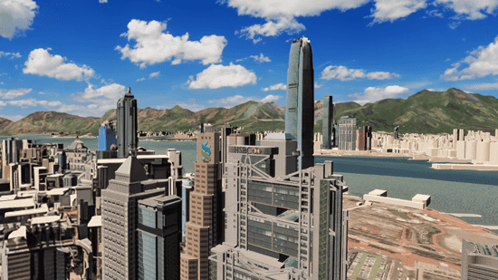
Hong Kong, China
- Origin Position:
- Longitude: 12711318.749199504
- Latitude: 2548866.1456997376
- Altitude: 0
- Spatial Reference WKID: 3857
- Camera Position:
- Longitude: 114.159775
- Latitude: 22.278694
- Altitude: 193.049879
- Spatial Reference WKID: 3857
- Camera Rotation:
- Heading: 335.457335
- Pitch: 87.644199
- Roll: 359.963549
- Data Layers:
- ArcGIS Online item: LandsD 3D-BIT00 Building Models (Level 3)
- Type:
ArcGIS 3 D Object Scene Layer - Online service URL (source):
Use dark colors for code blocks Copy https://tiles.arcgis.com/tiles/6j1KwZfY2fZrfNMR/arcgis/rest/services/Buildings_L3_1/SceneServer - ArcGIS Online item: LandsD 3D-BIT00 Building Models (Level 1)
- Type:
ArcGIS 3 D Object Scene Layer - Online service URL (source):
Use dark colors for code blocks Copy https://tiles.arcgis.com/tiles/6j1KwZfY2fZrfNMR/arcgis/rest/services/Buildings_L1/SceneServer
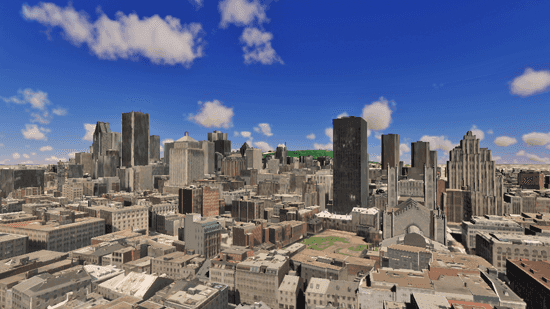
Montréal, QC, Canada
- Origin Position:
- Longitude: -73.603857
- Latitude: 45.485825
- Altitude: 0
- Spatial Reference WKID: 4326
- Camera Position:
- Longitude: -73.553191
- Latitude: 45.503395
- Altitude: 86.81108
- Spatial Reference WKID: 4326
- Camera Rotation:
- Heading: 272.372871
- Pitch: 91.065579
- Roll: 0.019082
- Data Layers:
- ArcGIS Online item: Montreal Buildings v17
- Type:
ArcGIS 3 D Object Scene Layer - Online service URL (source):
Use dark colors for code blocks Copy https://tiles.arcgis.com/tiles/z2tnIkrLQ2BRzr6P/arcgis/rest/services/Montreal_Buildings_v17_21778/SceneServer
New York City, NY, United States
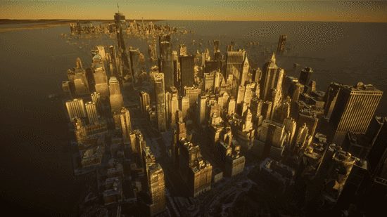
- Origin Position:
- Longitude: -74
- Latitude: 41
- Altitude: 0
- Spatial Reference WKID: 4326
- Camera Position:
- Longitude: -74.019482
- Latitude: 40.703023
- Altitude: 410.095521
- Spatial Reference WKID: 4326
- Camera Rotation:
- Heading: 44.358559
- Pitch: 64.646284
- Roll: 0.217526
- Data Layers:
- ArcGIS Online item: New York Mesh
- Type:
ArcGIS Integrated Mesh Layer - Online service URL (source):
Use dark colors for code blocks Copy https://tiles.arcgis.com/tiles/z2tnIkrLQ2BRzr6P/arcgis/rest/services/New_York_Mesh/SceneServer
Norfolk, VA, United States

- Origin Position:
- Longitude: -76.332562
- Latitude: 36.82648
- Altitude: 0
- Spatial Reference WKID: 4326
- Camera Position:
- Longitude: -76.288029
- Latitude: 36.841503
- Altitude: 74.70372
- Spatial Reference WKID: 4326
- Camera Rotation:
- Heading: 333.352814
- Pitch: 93.610245
- Roll: 0.038673
- Data Layers:
- ArcGIS Online item: Norfolk_nearmap_mesh_repaired
- Type:
ArcGIS Integrated Mesh Layer - Online service URL (source):
Use dark colors for code blocks Copy https://tiles.arcgis.com/tiles/P3ePLMYs2RVChkJx/arcgis/rest/services/Norfolk_nearmap_mesh_repaired/SceneServer
Paris, France
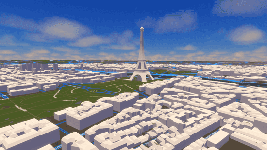
- Origin Position:
- Longitude: 2.2235586454728073
- Latitude: 48.814136238670834
- Altitude: 0
- Spatial Reference WKID: 4326
- Camera Position:
- Longitude: 2.304961
- Latitude: 48.856627
- Altitude: 145.967285
- Spatial Reference WKID: 4326
- Camera Rotation:
- Heading: 279.948727
- Pitch: 83.663647
- Roll: 0.051507
- Data Layers:
- ArcGIS Online item: Batiments_3D_Paris
- Type:
ArcGIS 3 D Object Scene Layer - Online service URL (source):
Use dark colors for code blocks Copy https://services.arcgis.com/d3voDfTFbHOCRwVR/arcgis/rest/services/Batiments_3D_Paris/SceneServer - ArcGIS Online item: Batiments_Remarquables_3D
- Type:
ArcGIS 3 D Object Scene Layer - Online service URL (source):
Use dark colors for code blocks Copy https://services.arcgis.com/V6ZHFr6zdgNZuVG0/arcgis/rest/services/Batiments_Remarquables_3D/SceneServer - ArcGIS Online item: World Street Map (Night - WGS84)
- Type:
ArcGIS Vector Tile Layers - Online service URL (source):
Use dark colors for code blocks Copy https://basemaps.arcgis.com/arcgis/rest/services/World_Basemap_GCS_v2/VectorTileServer
Prague, Czech Republic
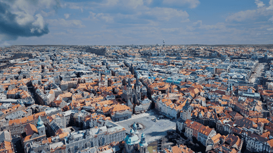
- Origin Position:
- Longitude: 14.37945
- Latitude: 50.050415
- Altitude: 0
- Spatial Reference WKID: 4326
- Camera Position:
- Longitude: 14.419029
- Latitude: 50.087881
- Altitude: 283.890089
- Spatial Reference WKID: 4326
- Camera Rotation:
- Heading: 100.738976
- Pitch: 67.3977977
- Roll: 359.954803
- Data Layers:
- ArcGIS Online item: Prague Integrated Mesh
- Type:
ArcGIS Integrated Mesh Layer - Online service URL (source):
Use dark colors for code blocks Copy https://tiles.arcgis.com/tiles/cbDaIA5xFnHBUlC1/arcgis/rest/services/Prague_3D_Mesh_Example/SceneServer
Tokyo, Japan

- Origin Position:
- Longitude: 139.685762
- Latitude: 35.532655
- Altitude: 0
- Spatial Reference WKID: 4326
- Camera Position:
- Longitude: 139.737876
- Latitude: 35.658697
- Altitude: 134.894836
- Spatial Reference WKID: 4326
- Camera Rotation:
- Heading: 71.783824
- Pitch: 94.617766
- Roll: 359.893258
- Data Layers:
- ArcGIS Online item: Tokyo23ku_LOD2_Building
- Type:
ArcGIS 3 D Object Scene Layer - Online service URL (source):
Use dark colors for code blocks Copy https://tiles.arcgis.com/tiles/wlVTGRSYTzAbjjiC/arcgis/rest/services/Tokyo23ku_LOD2_Building/SceneServer