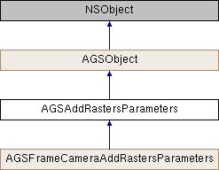
Description
Adds raster datasets to an AGSMosaicDatasetRaster by setting various parameters.
Mosaic datasets (via the AGSMosaicDatasetRaster class) are used to manage, display, serve, and share raster data. When you create a new mosaic dataset, it is created as an empty container in a geodatabase to which you can add raster data. The AGSAddRastersParameters object provides the mechanism to set various properties, so that a raster can be added to a mosaic dataset via the AGSMosaicDatasetRaster::addRastersWithParameters:completion: method.
Some of the parameters (aka. properties) on AGSAddRastersParameters class that enable adding a raster into a mosaic dataset include specifying the file filter type (like .tif or .jpg) of the rasters that are to be included (AGSAddRastersParameters::filter property), the directory location (AGSAddRastersParameters::inputDirectory property) of the raster files, the minimum pixel cell size of the raster to be included (AGSAddRastersParameters::minPixelSizeFactor property) and more.
- Since
- 100

Class Methods | |
| (instancetype) | + addRastersParameters |
Properties | |
| NSString * | filter |
| NSURL * | inputDirectoryURL |
| NSURL * | inputFileURL |
| double | maxPixelSizeFactor |
| double | minPixelSizeFactor |
| NSURL * | rasterFunctionTemplateFileURL |
Method Documentation
◆ addRastersParameters
| + (instancetype) addRastersParameters |
Property Documentation
◆ filter
|
readwritenonatomiccopy |
A filter for the raster data being added to the mosaic dataset. It is a regular expression with ECMA-262 grammar (https://262.ecma-international.org/5.1/#sec-15.10) used to filter rasters based on their filename.
- Since
- 100
◆ inputDirectoryURL
|
readwritenonatomicstrong |
URL to a folder containing multiple raster datasets to be added to the mosaic dataset raster.
- Since
- 100
◆ inputFileURL
|
readwritenonatomicstrong |
URL to a CSV file that contains the list of rasters and their properties are to be added to the mosaic dataset raster
- Since
- 100
◆ maxPixelSizeFactor
|
readwritenonatomicassign |
- Since
- 100
◆ minPixelSizeFactor
|
readwritenonatomicassign |
- Since
- 100
◆ rasterFunctionTemplateFileURL
|
readwritenonatomicstrong |
URL to a JSON file that contains a raster function template which is applied to each input raster when adding them to a mosaic dataset.
- Since
- 100