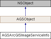
Description
Metadata of an ArcGIS Image Service.
An instance of this class represents metadata for an ArcGIS Image Service
- See also
AGSImageServiceRaster
- Since
- 100.1

Properties | |
| NSString * | attribution |
| NSString * | currentVersion |
| NSArray< AGSField * > * | fields |
| AGSEnvelope * | fullExtent |
| double | maxScale |
| double | minScale |
| NSString * | name |
| AGSPixelType | pixelType |
| NSArray< AGSRenderingRuleInfo * > * | renderingRuleInfos |
| AGSSpatialReference * | spatialReference |
| AGSLayerTimeInfo * | timeInfo |
| NSURL * | URL |
Property Documentation
◆ attribution
|
readnonatomiccopy |
Attribution text for the service
- Since
- 100.1
◆ currentVersion
|
readnonatomiccopy |
Version of the service
- Since
- 100.1
◆ fields
|
readnonatomiccopy |
The attribute fields (columns) available in the service's data.
- Since
- 100.1
◆ fullExtent
|
readnonatomicstrong |
Full geographic extent of the service
- Since
- 100.1
◆ maxScale
|
readnonatomicassign |
The maximum scale at which contents of the service is visible. If the map is zoomed in beyond this scale, the contents will not be visible.
- Since
- 100.1
◆ minScale
|
readnonatomicassign |
The minimum scale at which contents of the service is visible. If the map is zoomed out beyond this scale, the contents will not be visible.
- Since
- 100.1
◆ name
|
readnonatomiccopy |
Name of the service
- Since
- 100.1
◆ pixelType
|
readnonatomicassign |
Type of data, such as signed integer, unsigned integer, or floating point, contained in each pixel of the raster provided by the service.
- Since
- 100.1
◆ renderingRuleInfos
|
readnonatomiccopy |
Rendering rules available in the service
- Since
- 100.1
◆ spatialReference
|
readnonatomicstrong |
Spatial reference of the service's geographic data
- Since
- 100.1
◆ timeInfo
|
readnonatomicstrong |
◆ URL
|
readnonatomicstrong |
URL of the ArcGIS Image Service
- Since
- 100.1