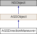
Description
A single maneuver in a series of driving direction.
Instances of this class represent an individual maneuver in a series of turn-by-turn driving directions.
- Since
- 100

Properties | |
| NSArray< AGSDirectionEvent * > * | directionEvents |
| NSString * | directionText |
| double | duration |
| double | estimatedArrivalTimeShift |
| NSDate * | estimatedArriveTime |
| NSInteger | fromLevel |
| AGSGeometry * | geometry |
| double | length |
| NSArray< AGSDirectionMessage * > * | maneuverMessages |
| AGSDirectionManeuverType | maneuverType |
| NSInteger | toLevel |
Property Documentation
◆ directionEvents
|
readnonatomiccopy |
Events along the maneuver
- Since
- 100
◆ directionText
|
readnonatomiccopy |
User-friendly text describing the maneuver
- Since
- 100
◆ duration
|
readnonatomicassign |
Duration (in minutes) of the maneuver
- Since
- 100
◆ estimatedArrivalTimeShift
|
readnonatomicassign |
Time zone shift in minutes (based on the destination of this manuever) for the estimated arrival time.
- Since
- 100
◆ estimatedArriveTime
|
readnonatomicstrong |
Estimated time of arrival at the destination of this manuever in the current locale of the device.
- Since
- 100
◆ fromLevel
|
readnonatomicassign |
The logical level at the start of the maneuver. The fromLevel and toLevel properties are defined to provide a way to filter directions based on logical level division. For example, a 3D routing application might render a 2D map with route lines filtered by vertical level instead of displaying overlapping lines on different levels. The fromLevel and toLevel properties are populated from source data and not calculated by the directions engine. If the source data does not contain "LevelFrom" and "LevelTo" fields, the properties will be populated with -1 values
- Since
- 100.2
◆ geometry
|
readnonatomicstrong |
Geometry representing the maneuver, be it a turn or travelling in a straight line.
- Since
- 100
◆ length
|
readnonatomicassign |
Length (in meters) of the maneuver
- Since
- 100
◆ maneuverMessages
|
readnonatomiccopy |
The detailed messages describing this manuever
- Since
- 100
◆ maneuverType
|
readnonatomicassign |
The maneuver type
- Since
- 100
◆ toLevel
|
readnonatomicassign |
The logical level at the end of the maneuver. The fromLevel and toLevel properties are defined to provide a way to filter directions based on logical level division. For example, a 3D routing application might render a 2D map with route lines filtered by vertical level instead of displaying overlapping lines on different levels. The fromLevel and toLevel properties are populated from source data and not calculated by the directions engine. If the source data does not contain "LevelFrom" and "LevelTo" fields, the properties will be populated with -1 values
- Since
- 100.2