AGSLevelOfDetail Class Reference
Description
A scale level in a tiling scheme.
Instances of this class represent an individual scale level of a tile cache's tiling scheme
- Since
- 100
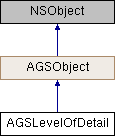
Inheritance diagram for AGSLevelOfDetail:

Instance Methods | |
| (instancetype) | - initWithLevel:resolution:scale: |
Class Methods | |
| (instancetype) | + levelOfDetailWithLevel:resolution:scale: |
Properties | |
| NSInteger | level |
| double | resolution |
| double | scale |
Method Documentation
◆ initWithLevel:resolution:scale:
| - (instancetype) initWithLevel: | (NSInteger) | level | |
| resolution: | (double) | resolution | |
| scale: | (double) | scale | |
Initialize a level of detail to represent a scale level of a tiling scheme
- Parameters
-
level of the desired scale level resolution of the desired scale level scale of the desired scale level
- Returns
- An initialized level of detail
- Since
- 100
◆ levelOfDetailWithLevel:resolution:scale:
| + (instancetype) levelOfDetailWithLevel: | (NSInteger) | level | |
| resolution: | (double) | resolution | |
| scale: | (double) | scale | |
Initialize a level of detail to represent a scale level of a tiling scheme
- Parameters
-
level of the desired scale level resolution of the desired scale level scale of the desired scale level
- Returns
- An initialized level of detail
- Since
- 100
Property Documentation
◆ level
|
readnonatomicassign |
ID for the scale level. The top most level is 0. This level represents the finest level of detail.
- Since
- 100
◆ resolution
|
readnonatomicassign |
Resolution, in map units, of each pixel in a tile for the scale level.
- Since
- 100
◆ scale
|
readnonatomicassign |
Scale for the level.
- Since
- 100