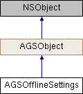
Description
Represents settings in an online web map which the author has configured for offline use.
Offline settings can be configured by a web map author to provide default values which are appropriate for taking a map offline. Applications which take the map offline can choose to ignore these offline settings when setting parameters for an AGSOfflineMapTask object.
The following methods will use the offline settings to set default parameter values:
defaultDownloadPreplannedOfflineMapParametersWithArea:completion: (AGSOfflineMapTask)defaultGenerateOfflineMapParametersWithAreaOfInterest:completion: (AGSOfflineMapTask)defaultGenerateOfflineMapParametersWithAreaOfInterest:minScale:maxScale:completion: (AGSOfflineMapTask)generateOfflineMapParameterOverridesWithParameters:completion: (AGSOfflineMapTask)
- Since
- 100.5

Properties | |
| AGSAttachmentSyncDirection | attachmentSyncDirection |
| NSArray< AGSLayer * > * | onlineLayers |
| NSArray< AGSServiceFeatureTable * > * | onlineTables |
| NSString * | referenceBasemapFilename |
| AGSReturnLayerAttachmentOption | returnLayerAttachmentOption |
| BOOL | returnSchemaOnlyForEditableLayers |
Property Documentation
◆ attachmentSyncDirection
|
readnonatomicassign |
A setting configured by the web map author that provides guidance for how attachments should be synced when working offline.
- If this setting is
AGSAttachmentSyncDirectionNone, then attachments should never be uploaded or downloaded when performing a sync operation. - If this setting is
AGSAttachmentSyncDirectionUpload, then attachments should be uploaded when performing sync. - If this setting is
AGSAttachmentSyncDirectionBidirectional, then attachments should be uploaded and downloaded when performing sync.
This value can be used to set a default for AGSGenerateOfflineMapParameters::attachmentSyncDirection. Alternatively, using AGSOfflineMapTask::createDefaultGenerateOfflineMapParametersWithAreaOfInterest:completion: will pre-populate the parameters using this property.
- Since
- 100.5
◆ onlineLayers
|
readnonatomiccopy |
Array of layers that the web map author determined will remain online when the map is taken offline.
Layers may be selected to remain online because they do not support being taken offline or to provide live contextual information such as traffic or weather.
- Since
- 100.10
◆ onlineTables
|
readnonatomiccopy |
Array of non-spatial tables that the web map author determined will remain online when the map is taken offline.
Tables may be selected to remain online because they do not support being taken offline or to provide live contextual information such as traffic or weather.
- Since
- 100.10
◆ referenceBasemapFilename
|
readnonatomiccopy |
The name of a local basemap file which can be used instead of downloading a basemap when taking this map offline.
Supported basemap formats are:
- .tpk
- .tpkx
- .vtpk The web map author sets this property to denote an appropriate basemap file. Client code is responsible for ensuring that the basemap has been correctly side-loaded to the device.
- Since
- 100.5
◆ returnLayerAttachmentOption
|
readnonatomicassign |
A setting configured by the web map author that indicates which feature layers should include attachments when taken offline.
Based on the value of this setting, attachments should be included with:
- None of the layers when the value is
AGSReturnLayerAttachmentOptionNone. - All of the layers when the value is
AGSReturnLayerAttachmentOptionAllLayers. - Read only layers when the value is
AGSReturnLayerAttachmentOptionReadOnlyLayers. - Editable layers when the value is
AGSReturnLayerAttachmentOptionEditableLayers.
This value can be used to set a default for AGSGenerateOfflineMapParameters::returnLayerAttachmentOption. Alternatively, using AGSOfflineMapTask::createDefaultGenerateOfflineMapParametersWithAreaOfInterest:completion: will pre-populate the parameters using this property.
- Since
- 100.5
◆ returnSchemaOnlyForEditableLayers
|
readnonatomicassign |
A setting configured by the web map author that indicates whether or not feature layers taken offline should be schema only and contain no data.
- If
YES, this setting means that feature layers should be taken offline with no existing data in them - If
NO, this setting means that existing features should be included when taking data offline for an editing workflow.
This value can be used to set a default for AGSGenerateOfflineMapParameters::returnSchemaOnlyForEditableLayers. Alternatively, using AGSOfflineMapTask::createDefaultGenerateOfflineMapParametersWithAreaOfInterest:completion: will pre-populate the parameters using this property.
- Since
- 100.5