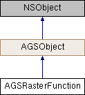
Description
A function used to apply on-the-fly processing to rasters.
An instance of this class represents a raster function that can be used to apply processing to rasters. This processing is applied on-the-fly so as not to change the original data.
Raster functions can be chained together to apply more complex processing to a raster. The chain works in such a way that the output of one raster function becomes the input to the raster function applied on top of it in the chain.
- See also
- Raster Function JSON syntax
- Since
- 100

Instance Methods | |
| (instancetype) | - initWithFileURL: |
Class Methods | |
| (id) | + fromJSON:error: |
| (instancetype) | + rasterFunctionWithFileURL: |
Properties | |
| AGSRasterFunctionArguments * | arguments |
| NSURL * | fileURL |
Method Documentation
◆ fromJSON:error:
| + (id) fromJSON: | (NSString *) | json | |
| error: | (NSError **) | error | |
◆ initWithFileURL:
| - (instancetype) initWithFileURL: | (NSURL *) | fileURL |
Initalize raster function using the provided file
- Parameters
-
fileURL to a JSON file containing a template for the raster function
- Returns
- Initialized raster function
- Since
- 100
◆ rasterFunctionWithFileURL:
| + (instancetype) rasterFunctionWithFileURL: | (NSURL *) | fileURL |
Initalize raster function using the provided file
- Parameters
-
fileURL to a JSON file containing a template for the raster function
- Returns
- Initialized raster function
- Since
- 100
Property Documentation
◆ arguments
|
readnonatomicstrong |
The arguments for the raster function. These arguments provide values for the place holders specified in the raster function template at fileURL.
- Since
- 100
◆ fileURL
|
readnonatomicstrong |
URL to a JSON file containing a template for the raster function
- Since
- 100