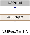
Description
Metadata about the network analyst service or dataset used by AGSRouteTask.
Instances of this class represent metadata about the network analyst service or dataset used by AGSRouteTask. It provides default values for the parameters created through defaultRouteParametersWithCompletion: (AGSRouteTask).
- Since
- 100

Properties | |
| NSArray< NSString * > * | accumulateAttributeNames |
| NSDictionary< NSString *, AGSCostAttribute * > * | costAttributes |
| NSString * | defaultTravelModeName |
| AGSUnitSystem | directionsDistanceUnits |
| NSString * | directionsLanguage |
| AGSDirectionsStyle | directionsStyle |
| AGSNetworkDirectionsSupport | directionsSupport |
| BOOL | findBestSequence |
| double | maxLocatingDistance |
| NSString * | networkName |
| AGSSpatialReference * | outputSpatialReference |
| BOOL | preserveFirstStop |
| BOOL | preserveLastStop |
| NSDictionary< NSString *, AGSRestrictionAttribute * > * | restrictionAttributes |
| AGSRouteShapeType | routeShapeType |
| NSDate * | startTime |
| NSArray< NSString * > * | supportedLanguages |
| NSArray< NSString * > * | supportedRestrictionUsageParameterValues |
| BOOL | supportsRerouting |
| NSArray< AGSTravelMode * > * | travelModes |
Property Documentation
◆ accumulateAttributeNames
|
readnonatomiccopy |
A list of network attributes that can be accumulated and returned as part of the route. You might want to perform the analysis using a distance-based impedance attribute and accumulate a time-based cost attribute. The results of this kind of analysis are based on distance, but they also specify how long it would take to reach a portion of the service area.
- Since
- 100
◆ costAttributes
|
readnonatomiccopy |
A list of cost attributes that can be used as a travel mode impedance (AGSTravelMode::impedanceAttributeName) to optimize the route. The key in the dictionary represents the name of the cost attribute.
- Since
- 100
◆ defaultTravelModeName
|
readnonatomiccopy |
◆ directionsDistanceUnits
|
readnonatomicassign |
The linear units used while providing distances for turn-by-turn directions.
- Since
- 100
◆ directionsLanguage
|
readnonatomiccopy |
The language used when computing directions. For example, en, fr, pt-BR, zh-Hans etc.
- Since
- 100
◆ directionsStyle
|
readnonatomicassign |
The style used for providing directions.
- Since
- 100
◆ directionsSupport
|
readnonatomicassign |
Whether the underlying network dataset supports the returning of directions. For services prior to ArcGIS 10.8, this value will be AGSNetworkDirectionsSupportUnknown.
- See also
AGSNetworkDirectionsSupport
- Since
- 100.7
◆ findBestSequence
|
readnonatomicassign |
Specifies whether or not to optimize the order of the stops in the route.
- Since
- 100
◆ maxLocatingDistance
|
readnonatomicassign |
Maximum locating distance is the furthest distance in meters that is searched when locating or relocating a point onto the network. The search looks for suitable edges or junctions and snaps the point to the nearest one. If a suitable location isn't found within the maximum locating distance, the object is marked as unlocated.
- Since
- 100.6
◆ networkName
|
readnonatomiccopy |
Name of the underlying transportation network dataset.
- Since
- 100
◆ outputSpatialReference
|
readnonatomicstrong |
The spatial reference in which the result geometries are returned, unless the AGSRouteParameters::outputSpatialReference property is specified.
- Since
- 100
◆ preserveFirstStop
|
readnonatomicassign |
If YES, keeps the first stop fixed in the sequence even when findBestSequence is enabled. Only applicable if findBestSequence is enabled.
- Since
- 100
◆ preserveLastStop
|
readnonatomicassign |
If YES, keeps the last stop fixed in the sequence even when the findBestSequence property is enabled. Only applicable if the findBestSequence property is enabled.
- Since
- 100
◆ restrictionAttributes
|
readnonatomiccopy |
The list of supported restrictions for constraining the route. The key in the dictionary represents the name of the restriction attribute.
- Since
- 100
◆ routeShapeType
|
readnonatomicassign |
Specifies the type of route geometry to return in the result AGSRoute::routeGeometry.
- Since
- 100
◆ startTime
|
readnonatomicstrong |
The time the route begins. If not specified, defaults to the time the task is executed.
- Since
- 100
◆ supportedLanguages
|
readnonatomiccopy |
The list of languages supported for generating turn-by-turn driving directions.
- Since
- 100
◆ supportedRestrictionUsageParameterValues
|
readnonatomiccopy |
The list of supported restriction parameter values.
- Since
- 100
◆ supportsRerouting
|
readnonatomicassign |
Indicates whether the network analyst service or dataset supports rerouting. If the property doesn't exist on a service, it will default to NO. For local data value will be YES.
- Since
- 100.6
◆ travelModes
|
readnonatomiccopy |
Specifies the available travel modes that can be used to customize the route.
- Since
- 100