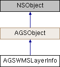
Description
Information about a layer in an OGC-WMS service.
An instance of this class represents information about an individual layer in an OGC-WMS service.
- Since
- 100.2

Properties | |
| AGSEnvelope * | extent |
| NSInteger | fixedImageHeight |
| NSInteger | fixedImageWidth |
| NSArray< NSString * > * | keywords |
| NSString * | layerDescription |
| NSString * | name |
| BOOL | opaque |
| BOOL | queryable |
| NSArray< AGSSpatialReference * > * | spatialReferences |
| NSArray< NSString * > * | styles |
| NSMutableArray< AGSWMSLayerInfo * > * | sublayerInfos |
| NSString * | title |
Property Documentation
◆ extent
|
readnonatomicstrong |
The geographic extent this layer covers
- Since
- 100.2
◆ fixedImageHeight
|
readnonatomicassign |
A value indicating the height (in points) of map images the service is capable of producing. When present and nonzero, it indicates that the server is not able to produce a map image at a height different from the fixed height indicated.
- Since
- 100.2
◆ fixedImageWidth
|
readnonatomicassign |
A value indicating the width (in points) of map images the service is capable of producing. When present and nonzero, it indicates that the server is not able to produce a map image at a width different from the fixed width indicated.
- Since
- 100.2
◆ keywords
|
readnonatomiccopy |
List of keywords describing the layer
- Since
- 100.2
◆ layerDescription
|
readnonatomiccopy |
A brief narrative description of the layer.
- Since
- 100.2
◆ name
|
readnonatomiccopy |
Name of the layer. Layers may have a name and a title. Only layers with a name are displayable. Layers with only a title are categories for other layers. Layers with a name may also have children; displaying these layers will display all sublayers.
- Since
- 100.2
◆ opaque
|
readnonatomicassign |
Indicates if the layer is opaque and obscures content of other layers below it. It describes the layer's data content, not the picture format of the map image. A true value indicates that the map data are mostly or completely opaque. A false value indicates that the map data represent vector features that probably do not completely fill space. In practice, a layer with opaque set to true is a good candidate for use as a basemap.
- Since
- 100.2
◆ queryable
|
readnonatomicassign |
Indicates whether the layer is queryable or not.
- Since
- 100.2
◆ spatialReferences
|
readnonatomiccopy |
The spatial reference of the layer
- Since
- 100.2
◆ styles
|
readnonatomiccopy |
Available styles for the layer. Styles are server-defined options for how the layer and its information are displayed. Note that the order of styles returned does not indicate which style is the default.
- Since
- 100.2
◆ sublayerInfos
|
readnonatomicstrong |
Sublayers of this layer.
- Since
- 100.2
◆ title
|
readnonatomiccopy |
Title of the layer. The title property is intended for use as a human-readable layer identification. The title is not unique. Note also that a layer with a title but no name describes a category for use as a container for sublayers.
- Since
- 100.2