LayerList component with actions

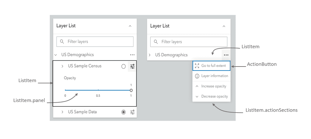
By default, the arcgis-layer-list component allows users to toggle layer visibility on and off in the map. List items represent a layer in the component. You can augment the layer list to allow users to perform custom actions for each layer by adding action buttons or toggles to each list item or add additional content to a list item's panel.

In this sample, we add custom actions to zoom to the layer's full extent, view the layer's REST endpoint, and modify the opacity of individual layers. We also add a slider to adjust the layer's opacity in the list item's panel. The actions and panel content are created by defining a listItemCreatedFunction property on the layer list. This function runs when each list item is created and returns an event object with the ListItem for that individual layer.
layerlist-actions

Add a layer list to the top right corner of the map. Set attributes to show the heading, collapse button and the filter input.

Use dark colors for code blocksCopy
1
2
3
4
5
6
7
8
9
10
11
12
13
14
15
16
17
18
19
20
21
22
23
24
25
26
27
28
29
30
31
32
33
34
35
36
37
38
39
40
41
42
43
44
45
46
47
48
49
50
51
52
53
54
55
56
57
58
59
60
61
62
63
64
65
66
67
68
69
70
71
72
73
74
75
76
77
78
79
80
81
82
83
84
85
86
87
88
89
90
91
92
93
94
95
96
97
98
99
100
101
102
103
104
105
106
107
108
109
110
111
112
113
114
115
116
117
118
119
120
121
122
123
124
125
126
127
128
129
130
131
132
133
134
135
136
137
138
139
140
141
142
143
144
145
146
147
148
149
150
151
152
153
154
155
156
157
158
159
160
161
162
163
164
165
166
167
168
169
170
171
172
173
174
175
176
177
178
179
180
181
182
183
184
185
186
187
188
189
190
191
192
193
194
195
196
197
198
199
200
201
202
203
204
205
206
207
208
209
210
211
212
213
214
      <arcgis-layer-list
        position="top-right"
        show-collapse-button
        show-heading
        show-filter
        filter-placeholder="Filter layers"
      ></arcgis-layer-list>

Define the actions for each ListItem in the listItemCreatedFunction function. This function is called for each ListItem when it's created for a layer.

Use dark colors for code blocksCopy
1
2
3
4
5
6
7
8
9
10
11
12
13
14
15
16
17
18
19
20
21
22
23
24
25
26
27
28
29
30
31
32
33
34
35
36
37
38
39
40
41
42
43
44
45
46
47
48
49
50
51
52
53
54
55
56
57
58
59
60
61
62
63
64
65
66
67
68
69
70
71
72
73
74
75
76
77
78
79
80
81
82
83
84
85
86
87
88
89
90
91
92
93
94
95
96
97
98
99
100
101
102
103
104
105
106
107
108
109
110
111
112
113
114
115
116
117
118
119
120
121
122
123
124
125
126
127
128
129
130
131
132
133
134
135
136
137
138
139
140
141
142
143
144
145
146
147
148
149
150
151
152
153
154
155
156
157
158
159
160
161
162
163
164
165
166
167
168
169
170
171
172
173
174
175
176
177
178
179
180
181
182
183
184
185
186
187
188
189
190
191
192
193
194
195
196
197
198
199
200
201
202
203
204
205
206
207
208
209
210
211
212
213
214
        // Get a reference to the arcgis-layer-list component.
        const arcgisLayerList = document.querySelector("arcgis-layer-list");

        // A function that executes each time a ListItem is created for a layer.
        arcgisLayerList.listItemCreatedFunction = (event) => {
          // The event object contains an item property.
          // It is a ListItem referencing the associated layer
          // and other properties. You can control the visibility of the
          // item, its title, and actions using this object.
          const { item } = event;

          // If the title of the item is "US Demographics"
          if (item.title === "US Demographics") {
            // A collection of ActionButtons to place in the LayerList.
            // By making this collection two-dimensional, you can separate similar
            // actions into separate groups with a breaking line.
            item.actionsSections = new Collection([
              new Collection([
                new ActionButton({
                  title: "Go to full extent",
                  icon: "zoom-out-fixed",
                  id: "full-extent"
                }),
                new ActionButton({
                  title: "Layer information",
                  icon: "information",
                  id: "information"
                })
              ]),
              new Collection([
                new ActionButton({
                  title: "Increase opacity",
                  icon: "chevron-up",
                  id: "increase-opacity"
                }),
                new ActionButton({
                  title: "Decrease opacity",
                  icon: "chevron-down",
                  id: "decrease-opacity"
                })
              ])
            ]);
          }

        };


Use the arcgisTriggerAction event to define the behavior of each action returned by the function.

Use dark colors for code blocksCopy
1
2
3
4
5
6
7
8
9
10
11
12
13
14
15
16
17
18
19
20
21
22
23
24
25
26
27
28
29
30
31
32
33
34
35
36
37
38
39
40
41
42
43
44
45
46
47
48
49
50
51
52
53
54
55
56
57
58
59
60
61
62
63
64
65
66
67
68
69
70
71
72
73
74
75
76
77
78
79
80
81
82
83
84
85
86
87
88
89
90
91
92
93
94
95
96
97
98
99
100
101
102
103
104
105
106
107
108
109
110
111
112
113
114
115
116
117
118
119
120
121
122
123
124
125
126
127
128
129
130
131
132
133
134
135
136
137
138
139
140
141
142
143
144
145
146
147
148
149
150
151
152
153
154
155
156
157
158
159
160
161
162
163
164
165
166
167
168
169
170
171
172
173
174
175
176
177
178
179
180
181
182
183
184
185
186
187
188
189
190
191
192
193
194
195
196
197
198
199
200
201
202
203
204
205
206
207
208
209
210
211
212
213
214
        // Event listener that fires each time an action is triggered
        arcgisLayerList.addEventListener("arcgisTriggerAction", (event) => {
          // The layer visible in the view at the time of the trigger.
          const visibleLayer = USALayer.visible ? USALayer : censusLayer;

          // Get a reference to the action id.
          const { id } = event.detail.action;

          // If the full-extent action is triggered then navigate
          // to the full extent of the visible layer
          if (id === "full-extent") {
            arcgisMap?.goTo(visibleLayer.fullExtent).catch((error) => {
              if (error.name != "AbortError") {
                console.error(error);
              }
            });
          }

          // If the information action is triggered, then
          // open the item details page of the service layer
          if (id === "information") {
            window.open(visibleLayer.url);
          }

          // If the increase-opacity action is triggered, then
          // increase the opacity of the GroupLayer by 0.25
          if (id === "increase-opacity") {
            if (demographicGroupLayer.opacity < 1) {
              demographicGroupLayer.opacity += 0.25;
            }
          }

          // If the decrease-opacity action is triggered, then
          // decrease the opacity of the GroupLayer by 0.25
          if (id === "decrease-opacity") {
            if (demographicGroupLayer.opacity > 0) {
              demographicGroupLayer.opacity -= 0.25;
            }
          }
        });

You can also specify custom content in the ListItem's panel. This can be any text, HTML node, or widget. For example, this app adds sliders to the panels of the two map image layers. Each slider updates the opacity of the respective layer.

Use dark colors for code blocksCopy
1
2
3
4
5
6
7
8
9
10
11
12
13
14
15
16
17
18
19
20
21
22
23
24
25
26
27
28
29
30
31
32
33
34
35
36
37
38
39
40
41
42
43
44
45
46
47
48
49
50
51
52
53
54
55
56
57
58
59
60
61
62
63
64
65
66
67
68
69
70
71
72
73
74
75
76
77
78
79
80
81
82
83
84
85
86
87
88
89
90
91
92
93
94
95
96
97
98
99
100
101
102
103
104
105
106
107
108
109
110
111
112
113
114
115
116
117
118
119
120
121
122
123
124
125
126
127
128
129
130
131
132
133
134
135
136
137
138
139
140
141
142
143
144
145
146
147
148
149
150
151
152
153
154
155
156
157
158
159
160
161
162
163
164
165
166
167
168
169
170
171
172
173
174
175
176
177
178
179
180
181
182
183
184
185
186
187
188
189
190
191
192
193
194
195
196
197
198
199
200
201
202
203
204
205
206
207
208
209
210
211
212
213
214
          // Add a calcite slider for updating opacity on group layers.
          if (item.layer.type === "map-image") {
            const label = document.createElement("calcite-label");
            label.innerText = "Opacity";
            label.scale = "s";

            const slider = document.createElement("calcite-slider");
            slider.labelHandles = true;
            slider.labelTicks = true;
            slider.min = 0;
            slider.minLabel = "0";
            slider.max = 1;
            slider.maxLabel = "1";
            slider.scale = "s";
            slider.step = 0.01;
            slider.value = 1;
            slider.ticks = 0.5;

            slider.addEventListener("calciteSliderChange", () => {
              item.layer.opacity = slider.value;
            });

            label.appendChild(slider);

            item.panel = {
              content: label,
              icon: "sliders-horizontal",
              title: "Change layer opacity"
            };
          }

Your browser is no longer supported. Please upgrade your browser for the best experience. See our browser deprecation post for more details.