ArcGIS Runtime SDK for iOS: AGSFrameCameraAddRastersParameters Class Reference
ArcGIS Runtime SDK for iOS  100.15
AGSFrameCameraAddRastersParameters Class Reference

Description

Adds raster datasets to an AGSMosaicDatasetRaster by setting various parameters including the use of frame and camera text files.

Mosaic datasets (via the AGSMosaicDatasetRaster class) are used to manage, display, serve, and share raster data. When you create a new mosaic dataset, it is created as an empty container in a geodatabase to which you can add raster data. The AGSFrameCameraAddRastersParameters object provides the mechanism to set various properties including the use of camera and frame text files so that a raster can be added to a mosaic dataset via the AGSMosaicDatasetRaster::addRastersWithParameters:completion: method.

Some of the parameters (aka. properties) on AGSFrameCameraAddRastersParameters class that enable adding a raster into a mosaic dataset include specifying, the file filter type (like .tif or .jpg) of the rasters that are to be included (AGSFrameCameraAddRastersParameters::filter property), the directory location (AGSFrameCameraAddRastersParameters::inputDirectory property) of the raster files, the minimum pixel cell size of the raster to be included (AGSFrameCameraAddRastersParameters::minPixelSizeFactor property) and more.

Unique attributes of using the AGSFrameCameraAddRastersParameters class rather than the parent AGSAddRastersParameters class have to do with defining 'frame' and 'camera' text files which specify how a raster image was captured from a satellite or aircraft. The frame and camera table files refer to a single perspective imaging camera with an optical lens that can be modeled as a pinhole. To define the frame table use the AGSFrameCameraAddRastersParameters::framesFile property, see the ArcGIS Pro document entitled 'Frames table schema' (https://pro.arcgis.com/en/pro-app/help/data/imagery/frames-table-schema.htm) for more information. To define the camera table use the AGSFrameCameraAddRastersParameters::camerasFile property, see the ArcGIS Pro document entitled 'Cameras table schema' (https://pro.arcgis.com/en/pro-app/help/data/imagery/cameras-table-schema.htm) for more information.

Since
100
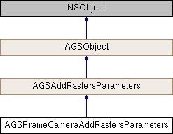
Inheritance diagram for AGSFrameCameraAddRastersParameters:
AGSAddRastersParameters AGSObject

Class Methods

(instancetype) + addRastersParameters
 
(instancetype) + frameCameraAddRastersParameters
 

Properties

NSURL * camerasFileURL
 
NSString * filter
 
NSURL * framesFileURL
 
NSURL * inputDirectoryURL
 
NSURL * inputFileURL
 
double maxPixelSizeFactor
 
double minPixelSizeFactor
 
NSURL * rasterFunctionTemplateFileURL
 
BOOL shareRasterInfo
 

Method Documentation

◆ addRastersParameters

+ (instancetype) addRastersParameters

◆ frameCameraAddRastersParameters

+ (instancetype) frameCameraAddRastersParameters

Initialize a frame camera add rasters parameters object to be used for adding rasters to a mosaic dataset raster.

Since
100

Property Documentation

◆ camerasFileURL

- (NSURL*) camerasFileURL
readwritenonatomicstrong

URL to the input cameras file on disk.

Since
100

◆ filter

- (NSString*) filter
readwritenonatomiccopyinherited

A filter for the raster data being added to the mosaic dataset. It is a regular expression with ECMA-262 grammar (https://262.ecma-international.org/5.1/#sec-15.10) used to filter rasters based on their filename.

Since
100

◆ framesFileURL

- (NSURL*) framesFileURL
readwritenonatomicstrong

URL to the input frames file on disk.

Since
100

◆ inputDirectoryURL

- (NSURL*) inputDirectoryURL
readwritenonatomicstronginherited

URL to a folder containing multiple raster datasets to be added to the mosaic dataset raster.

Since
100

◆ inputFileURL

- (NSURL*) inputFileURL
readwritenonatomicstronginherited

URL to a CSV file that contains the list of rasters and their properties are to be added to the mosaic dataset raster

Since
100

◆ maxPixelSizeFactor

- (double) maxPixelSizeFactor
readwritenonatomicassigninherited
Since
100

◆ minPixelSizeFactor

- (double) minPixelSizeFactor
readwritenonatomicassigninherited
Since
100

◆ rasterFunctionTemplateFileURL

- (NSURL*) rasterFunctionTemplateFileURL
readwritenonatomicstronginherited

URL to a JSON file that contains a raster function template which is applied to each input raster when adding them to a mosaic dataset.

Since
100

◆ shareRasterInfo

- (BOOL) shareRasterInfo
readwritenonatomicassign

Specifies whether to share raster info or not.

Since
100