Description
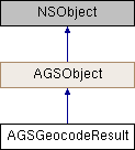
A match candidate returned from an AGSLocatorTask geocode or reverse geocode operation.
AGSGeocodeResult provides information about the candidate, such as a collection of requested attribute values, user-friendly label text, and locations suited for accurate match display or for routing input.
Instances of this class represent a result of a geocode/reverse-geocode operation on AGSLocatorTask
- Since
- 100

Properties | |
| NSDictionary< NSString *, id > * | attributes |
| AGSPoint * | displayLocation |
| AGSEnvelope * | extent |
| AGSPoint * | inputLocation |
| NSString * | label |
| AGSPoint * | routeLocation |
| double | score |
Property Documentation
◆ attributes
|
readnonatomiccopy |
A collection of attributes as requested by AGSGeocodeParameters::resultAttributeNames or AGSReverseGeocodeParameters::resultAttributeNames.
Available attributes depend on the data stored with the locator, and can include things like place name, URL, phone number, and so on.
- Since
- 100
◆ displayLocation
|
readnonatomicstrong |
Location of the candidate suitable for display on a map.
For example, this may provide a more precise rooftop location of a house, whereas AGSGeocodeResult::routeLocation represents the nearest street location.
- Since
- 100
◆ extent
|
readnonatomicstrong |
An extent suitable for zooming the map to display the candidate.
- Since
- 100
- See also
- setViewpoint: (AGSGeoView)
◆ inputLocation
|
readnonatomicstrong |
The AGSPoint provided as input to reverseGeocodeWithLocation:completion: (AGSLocatorTask). Only applicable for results of reverse-geocode operations.
- Since
- 100
◆ label
|
readnonatomiccopy |
User-friendly text that describes this result.
- Since
- 100
◆ routeLocation
|
readnonatomicstrong |
The nearest street location for the result.
Use this location if you want to use the candidate as a stop in a route. For example, AGSGeocodeResult::displayLocation may provide a more precise rooftop location of a house, whereas AGSGeocodeResult::routeLocation will provide the nearest street location.
- Since
- 100
◆ score
|
readnonatomicassign |
A value that indicates how well the address was matched.
The score is in a range between 0 (no match) and 100 (perfect match).
- Since
- 100