Description
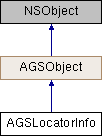
Metadata about the locator service or dataset used by AGSLocatorTask.
Instances of this class represent metadata about the locator service or dataset used by AGSLocatorTask.
- Since
- 100

Properties | |
| NSArray< AGSLocatorAttribute * > * | intersectionResultAttributes |
| NSString * | locatorDescription |
| NSString * | name |
| NSDictionary< NSString *, NSString * > * | properties |
| NSArray< AGSLocatorAttribute * > * | resultAttributes |
| NSArray< AGSLocatorAttribute * > * | searchAttributes |
| AGSSpatialReference * | spatialReference |
| BOOL | supportsAddresses |
| BOOL | supportsIntersections |
| BOOL | supportsPOI |
| BOOL | supportsSuggestions |
| NSString * | version |
Property Documentation
◆ intersectionResultAttributes
|
readnonatomiccopy |
The attribute fields that can be returned in the results of geocode or reverse geocode operations when searching for street intersections.
- See also
AGSLocatorAttribute
- Since
- 100
◆ locatorDescription
|
readnonatomiccopy |
Description of the locator service or dataset.
- Since
- 100
◆ name
|
readnonatomiccopy |
Name of the locator service or dataset.
- Since
- 100
◆ properties
|
readnonatomiccopy |
The locator properties. For example, MinimumCandidateScore, SideOffsetUnits, SpellingSensitivity, MinimumMatchScore and so on.
- Since
- 100
◆ resultAttributes
|
readnonatomiccopy |
The attribute fields that can be returned in the results of geocode or reverse geocode operations when searching for addresses or places.
- See also
AGSLocatorAttribute
- Since
- 100
◆ searchAttributes
|
readnonatomiccopy |
The search attributes that can be used as inputs to multi-line geocode operations. Each attribute represents an individual address component in a multi-line address.
- See also
AGSLocatorAttribute
- Since
- 100
◆ spatialReference
|
readnonatomicstrong |
The default spatial reference in which result geometries are returned, unless overriden in AGSGeocodeParameters or AGSReverseGeocodeParameters.
- Since
- 100
◆ supportsAddresses
|
readnonatomicassign |
Indicates whether geocoding addresses is supported. If supported, these can be specified as x/y coordinate pairs in the search text for geocode operations, where the spatial reference of the coordinates is WGS84. For example, "-115.172783,36.114789".
- Since
- 100
◆ supportsIntersections
|
readnonatomicassign |
Indicates whether geocoding street intersections is supported.
- Since
- 100
◆ supportsPOI
|
readnonatomicassign |
Indicates whether geocoding points of interest is supported.
- Since
- 100
◆ supportsSuggestions
|
readnonatomicassign |
Indicates whether getting suggestions for geocode operations is supported.
- Since
- 100
◆ version
|
readnonatomiccopy |
Version of the locator service or dataset.
- Since
- 100