Description
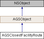
An individual route between a facility and an incident.
Instances of this class represent an individual route between a facility and an incident that is available through AGSClosestFacilityResult::routeForFacilityIndex:incidentIndex .
- Since
- 100.1

Instance Methods | |
| (double) | - costForCostAttribute: |
Properties | |
| AGSCurbApproach | arrivalCurbApproach |
| AGSCurbApproach | departureCurbApproach |
| NSArray< AGSDirectionManeuver * > * | directionManeuvers |
| NSDate * | endTime |
| double | endTimeShift |
| AGSPolyline * | routeGeometry |
| NSDate * | startTime |
| double | startTimeShift |
| double | totalLength |
| double | totalTime |
| double | travelTime |
Method Documentation
◆ costForCostAttribute:
| - (double) costForCostAttribute: | (NSString *) | attributeName |
Property Documentation
◆ arrivalCurbApproach
|
readnonatomicassign |
Side of curb at which the route arrives at the destination
- Since
- 100.1
◆ departureCurbApproach
|
readnonatomicassign |
Side of curb at which the route departs the origin
- Since
- 100.1
◆ directionManeuvers
|
readnonatomiccopy |
Turn-by-turn driving directions along this route. Only available if AGSClosestFacilityParameters::returnDirections is enabled.
- Since
- 100.1
◆ endTime
|
readnonatomicstrong |
Time when the route ends (arriving at the last stop) in the current locale of the device.
- Since
- 100.1
◆ endTimeShift
|
readnonatomicassign |
Time zone shift in minutes (based on the time zone of the last stop) for the end time.
- Since
- 100.1
◆ routeGeometry
|
readnonatomicstrong |
The route geometry.
- Since
- 100.1
◆ startTime
|
readnonatomicstrong |
Time when the route begins (departing from the first stop) in the current locale of the device.
- Since
- 100.1
◆ startTimeShift
|
readnonatomicassign |
Time zone shift in minutes (based on the time zone of the last stop) for the start time.
- Since
- 100.1
◆ totalLength
|
readnonatomicassign |
Total distance (in meters) covered by the route.
- Since
- 100.1
◆ totalTime
|
readnonatomicassign |
Overall time (in minutes) taken by the route from start to end. This includes travelTime and #waitTime.
- Since
- 100.1
◆ travelTime
|
readnonatomicassign |
Total time (in minutes) spent travelling along the route.
- Since
- 100.1