require(["esri/rest/support/AttributeBinsQuery"], (AttributeBinsQuery) => { /* code goes here */ });
import AttributeBinsQuery from "@arcgis/core/rest/support/AttributeBinsQuery.js";
esri/rest/support/AttributeBinsQuery
This class configures parameters for the queryAttributeBins() method, which groups features in a layer or layer view into bins based on numeric or date fields. This operation is useful for summarizing and analyzing large datasets by organizing them into meaningful groups, or bins, making it easier to detect patterns, trends, and anomalies across different ranges or time periods.
The binParameters property defines bin characteristics like size and start value, while the outStatistics parameter specifies the information each bin provides.
Features can be filtered using a where condition and a spatial filter. Bins are arranged consecutively with no gaps:
they are left-inclusive and right-exclusive, except for the last bin, which is right-inclusive. The method supports multiple statistical aggregations per bin and defaults to
a histogram of value frequencies/counts if no specific aggregations are provided in outStatistics.
Bins are defined using one of the bin parameters, each supporting distinct parameters for handling boundaries between bins. Understanding the purpose of each bin parameter is crucial for understanding binning and boundary settings. There are four types of bin parameters:
| Bin parameter type | Description |
|---|---|
| AutoIntervalBinParameters | You specify the number of bins, start and end values of the binning. The bin size is calculated by dividing the dataset's range by this number of bins. |
| FixedBoundariesBinParameters | The bins strictly follow the specified input values. The first item in the array specifies the lower boundary of the first bin, while the last item specifies the upper boundary of the last bin. Intermediate values represent the lower boundaries of each bin. |
| FixedIntervalBinParameters | The number of bins is not important, but the interval size must match the input data. Each bin will cover a range that exactly fits the specified interval. |
| DateBinParameters | The intervals are based on calendar units. For example, with monthly intervals, each bin represents an entire month. |
Constructors
-
Parameterproperties Objectoptional
See the properties for a list of all the properties that may be passed into the constructor.
Property Overview
| Name | Type | Summary | Class |
|---|---|---|---|
Bins can be returned in ascending or descending order. | AttributeBinsQuery | ||
Bin parameters describe the characteristics of the bins, including their size and starting value. | AttributeBinsQuery | ||
Indicates if the service should cache the query results. | AttributeBinsQuery | ||
Datum transformation used for projecting geometries in the query results when outSpatialReference is different than the layer's spatial reference. | AttributeBinsQuery | ||
The name of the class. | Accessor | ||
Specifies a search distance from a given geometry in a spatial query. | AttributeBinsQuery | ||
The geometry to apply to the spatial filter. | AttributeBinsQuery | ||
Sets the name of the lower boundary property in the response. | AttributeBinsQuery | ||
The spatial reference for the returned geometry. | AttributeBinsQuery | ||
The definitions for one or more field-based statistics to be calculated. | AttributeBinsQuery | ||
Defines the IANA time zone used for bin calculations when the bin parameter field is a date field. | AttributeBinsQuery | ||
If | AttributeBinsQuery | ||
For spatial queries, this parameter defines the spatial relationship to query features in the layer or layer view against the input geometry. | AttributeBinsQuery | ||
A time extent for a temporal query against time-aware layers. | AttributeBinsQuery | ||
The unit for calculating the buffer distance when distance is specified in spatial queries. | AttributeBinsQuery | ||
Sets the name of the upper boundary property in the response. | AttributeBinsQuery | ||
A where clause for the query. | AttributeBinsQuery |
Property Details
-
Bins can be returned in ascending or descending order. The default is
ascending.Possible Values:"ascending" |"descending"
- Default Value:"ascending"
-
binParameters
PropertybinParameters AutoIntervalBinParameters |FixedIntervalBinParameters |FixedBoundariesBinParameters |DateBinParametersautocast -
Bin parameters describe the characteristics of the bins, including their size and starting value. Each bin's size can either be specified by a parameter or calculated dynamically. Additionally, bins can be based on either date or numeric values.
- Default Value:null
-
Indicates if the service should cache the query results. It only applies if the layer's capabilities.query.supportsCacheHint is set to
true. Use only for queries that have the same parameters every time the app is used. Some examples of cacheable queries:- Queries that fetch statistics or features on app load.
- Queries based on preset input, for example, a drop-down list of US states.
- Queries based on preset extents, for example bookmarks, in web maps.
- Default Value:undefined
-
datumTransformation
PropertydatumTransformation Number |SimpleTransformation |CompositeTransformation |null |undefined -
Datum transformation used for projecting geometries in the query results when outSpatialReference is different than the layer's spatial reference. Requires ArcGIS Server service 10.5 or greater.
-
Specifies a search distance from a given geometry in a spatial query. The units property indicates the unit of measurement. In essence, setting this property creates a buffer at the specified size around the input geometry. The query will use that buffer to return features in the layer or layer view that adhere to the to the indicated spatial relationship.
If querying a feature service, the supportsQueryWithDistance capability must be
true.
-
geometry
Propertygeometry GeometryUnion |null |undefinedautocast -
The geometry to apply to the spatial filter. The spatialRelationship will indicate how the geometry should be used to query features.
Known Limitations
Mesh geometry types are currently not supported.
-
Sets the name of the lower boundary property in the response. By default, the lower boundary is name
lowerBoundaryand indicates the value at the edge of each bin.- Default Value:null
-
outSpatialReference
PropertyoutSpatialReference SpatialReference |null |undefinedautocast -
The spatial reference for the returned geometry. If not specified, the geometry is returned in the spatial reference of the queried layer.
-
outStatistics
PropertyoutStatistics StatisticDefinition[] |null |undefinedautocast -
The definitions for one or more field-based statistics to be calculated. For service-based queries, check the layer's queryAttributeBins.supportedStatistics capabilities to ensure that the layer supports statistics queries.
Example// get the average temperature for each bin let statisticDefinition = new StatisticDefinition({ statisticType: "avg", onStatisticField: "temp", outStatisticFieldName: "temp_avg" }); // Query bins with fixed interval bin parameters based on field "temp" with 5 degrees interval. const binQuery = new AttributeBinsQuery({ binParameters: new FixedIntervalBinParameters({ interval: 5, // the interval size for each bin. In this case, 5 degrees celsius field: "temp", // the field to bin, containing the temperature data start: 0, // the lower boundary of the first bin. 0 degrees celsius end: 30 // the upper boundary of the last bin. 30 degrees celsius }), // get the average temperature for each bin outStatistics: [statisticDefinition] });
-
Defines the IANA time zone used for bin calculations when the bin parameter field is a date field. If not specified, the UTC time zone is used for binning calculations. When a time zone is specified, dates and times will be adjusted according to that IANA time zone.
Example// Query bins with date interval bin parameters based on field "date" with monthly intervals. const binQuery = new AttributeBinsQuery({ binParameters: new DateBinParameters({ interval: 3, field: "RecordedDate", start: new Date(Date.UTC(1980, 0, 2, 0, 0)), end: new Date(Date.UTC(1980, 2, 1, 0, 0)), number: "1", unit: "months" }), outTimeZone: "America/New_York" // Get the binning results in Eastern Time Zone });
-
If
truethen the query returns distinct values based on the field(s) specified in outFields.Known Limitations
- For service-based queries, this parameter applies only if the
supportsAdvancedQueriescapability of the layer istrue. - Make sure to set returnGeometry to
falsewhenreturnDistinctValuesis true. Otherwise, reliable results will not be returned.
- Default Value:false
- For service-based queries, this parameter applies only if the
-
spatialRelationship
PropertyspatialRelationship String -
For spatial queries, this parameter defines the spatial relationship to query features in the layer or layer view against the input geometry. The spatial relationships discover how features are spatially related to each other. For example, you may want to know if a polygon representing a county completely contains points representing settlements.
The spatial relationship is determined by whether the boundaries or interiors of a geometry intersect.
- Boundary — The endpoints of all linear parts for line features, or the linear outline of a polygon. Only lines and polygons have boundaries.
- Interior — Points are entirely interior and have no boundary. For lines and polygons, the interior is any part of the geometry that is not part of the boundary.
The possible values for this parameter are described below and the images highlight the geometries returned for the specified spatial relationship for given geometries.
The
intersectsspatial relationship returns features in the layer view that intersect the query geometry.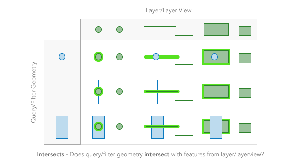
The
containsspatial relationship returns features in the layer view that are completely contained by the query geometry.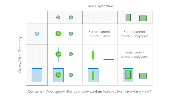
The
crossesspatial relationship returns features in the layer view when the interior of a query geometry comes into contact with the interior or boundary of features in the layer view. In other words, the geometries share some interior area, but not all interior area.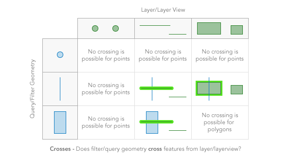
The
envelope-intersectsspatial relationship returns features in the layer view that intersect the envelope (or extent) of the filter geometry.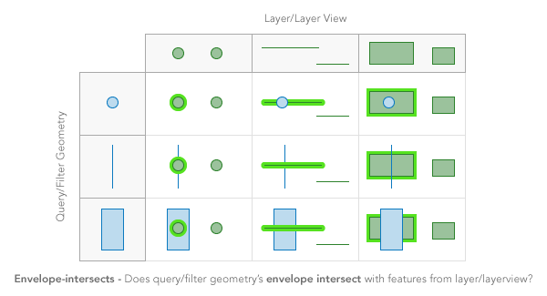
The
overlapsspatial relationship returns features in the layer view that overlap the query geometry. Only features of the same geometry can be compared.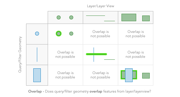
The
touchesspatial relationship returns features in the layer view that touch the query geometry. The boundaries of the geometries intersect, but not their interiors.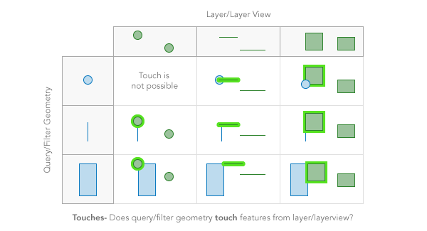
The
withinspatial relationship returns features in the layer view that completely contain the query geometry. In other words, the filter geometry is completelywithinthe features in the layer view. It is opposite ofcontains.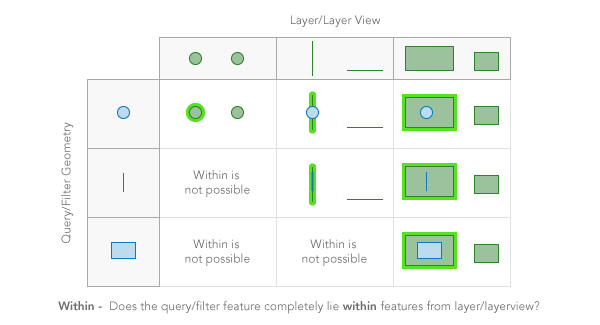
The
disjointspatial relationship returns features in the layer view that do not intersect the query geometry in anyway. Opposite ofintersects.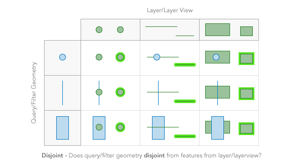
Known Limitations
- For spatial queries on 3D Object SceneLayers and BuildingSceneLayers the spatial relationship is evaluated based on the Extent of the feature and not the footprint. This means that a feature might be returned from the query, even though its footprint is not in a spatial relationship with the geometry.
- Currently only
intersects,contains, anddisjointspatialRelationships are supported on spatial queries for 3D Object SceneLayers and BuildingSceneLayers.
Possible Values:"intersects" |"contains" |"crosses" |"disjoint" |"envelope-intersects" |"index-intersects" |"overlaps" |"touches" |"within" |"relation"
- Default Value:intersects
Examplelet query = new Query({ spatialRelationship: "contains" });
-
timeExtent
PropertytimeExtent TimeExtent |null |undefinedautocast -
A time extent for a temporal query against time-aware layers. For example, it can be used to discover all crimes that occurred during the night shift from 10 PM to 6 AM on a particular date.
Examplelet layer = new FeatureLayer( ... ); let timeExtent = new TimeExtent({ start: new Date(1992, 0, 1), end: new Date(1992, 11, 31) }); let timeQuery = new Query({ timeExtent: timeExtent }); layerView.queryFeatures(timeQuery).then(function(featureSet) { ... });
-
The unit for calculating the buffer distance when distance is specified in spatial queries. If
unitsis not specified, the unit is derived from the geometry spatial reference. If the geometry spatial reference is not specified, the unit is derived from the feature service data spatial reference. For service-based queries, this parameter only applies if the layer's capabilities.query.supportsDistance istrue.Possible Values:"feet" |"miles" |"nautical-miles" |"us-nautical-miles" |"meters" |"kilometers"
- Default Value:null
Example// Query at a distance in pixels of the query geometry. // Use the unit of the query geometry's spatial reference. layerView.queryFeatures({ geometry: event.mapPoint, distance: 2 * view.resolution, returnGeometry: true }).then(processResults);
-
Sets the name of the upper boundary property in the response. By default, the upper boundary is name
upperBoundaryand indicates the value at the edge of each bin.- Default Value:null
-
A where clause for the query. Any legal SQL where clause operating on the fields in the layer is allowed. Be sure to have the correct sequence of single and double quotes when writing the where clause in JavaScript.
Examplesquery.where = "NAME = '" + stateName + "'";query.where = "POP04 > " + population;
Method Overview
| Name | Return Type | Summary | Class |
|---|---|---|---|
Adds one or more handles which are to be tied to the lifecycle of the object. | Accessor | ||
Creates a new instance of this class and initializes it with values from a JSON object generated from an ArcGIS product. | AttributeBinsQuery | ||
Returns true if a named group of handles exist. | Accessor | ||
Removes a group of handles owned by the object. | Accessor | ||
Converts an instance of this class to its ArcGIS portal JSON representation. | AttributeBinsQuery |
Method Details
-
Inherited from Accessor
-
Adds one or more handles which are to be tied to the lifecycle of the object. The handles will be removed when the object is destroyed.
// Manually manage handles const handle = reactiveUtils.when( () => !view.updating, () => { wkidSelect.disabled = false; }, { once: true } ); this.addHandles(handle); // Destroy the object this.destroy();ParametershandleOrHandles WatchHandle|WatchHandle[]Handles marked for removal once the object is destroyed.
groupKey *optionalKey identifying the group to which the handles should be added. All the handles in the group can later be removed with Accessor.removeHandles(). If no key is provided the handles are added to a default group.
-
Creates a new instance of this class and initializes it with values from a JSON object generated from an ArcGIS product. The object passed into the input
jsonparameter often comes from a response to a query operation in the REST API or a toJSON() method from another ArcGIS product. See the Using fromJSON() topic in the Guide for details and examples of when and how to use this function.Parameterjson ObjectA JSON representation of the instance in the ArcGIS format. See the ArcGIS REST API documentation for examples of the structure of various input JSON objects.
Returns
-
hasHandles
InheritedMethodhasHandles(groupKey){Boolean}Inherited from Accessor -
Returns true if a named group of handles exist.
ParametergroupKey *optionalA group key.
ReturnsType Description Boolean Returns trueif a named group of handles exist.Example// Remove a named group of handles if they exist. if (obj.hasHandles("watch-view-updates")) { obj.removeHandles("watch-view-updates"); }
-
Inherited from Accessor
-
Removes a group of handles owned by the object.
ParametergroupKey *optionalA group key or an array or collection of group keys to remove.
Exampleobj.removeHandles(); // removes handles from default group obj.removeHandles("handle-group"); obj.removeHandles("other-handle-group");
-
toJSON
MethodtoJSON(){Object} -
Converts an instance of this class to its ArcGIS portal JSON representation. See the Using fromJSON() guide topic for more information.
ReturnsType Description Object The ArcGIS portal JSON representation of an instance of this class.