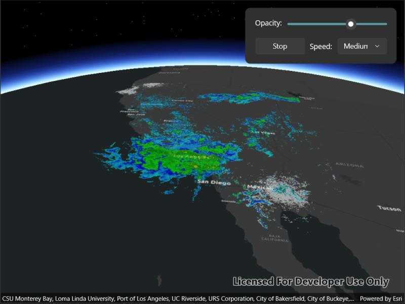
Animate a series of images with an image overlay.

Use case
An image overlay is useful for displaying fast and dynamic images; for example, rendering real-time sensor data captured from a drone. Each frame from the drone becomes a static image which is updated on the fly as the data is made available.
How to use the sample
The application loads a map of the Southwestern United States. Tap the "Start" or "Stop" buttons to start or stop the radar animation. Use the drop down menu to select how quickly the animation plays. Move the slider to change the opacity of the image overlay.
How it works
- Create an
ImageOverlayand add it to theSceneView. - Set up a timer with an initial interval time of 67ms, which will display approximately 15 image frames per second.
- Connect an event to the timer.
- Create a new
ImageFrameevery timeout and set it on the image overlay.
Relevant API
- ImageFrame
- ImageOverlay
- SceneView
Offline data
This sample uses radar images captured by the National Weather Service.
About the data
These radar images were captured by the US National Weather Service (NWS). They highlight the Pacific Southwest sector which is made up of part the western United States and Mexico. For more information visit the National Weather Service website.
Additional information
The supported image formats are GeoTIFF, TIFF, JPEG, and PNG. ImageOverlay does not support the rich processing and rendering capabilities of a RasterLayer. Use Raster and RasterLayer for static image rendering, analysis, and persistence.
Tags
3d, animation, drone, dynamic, image frame, image overlay, real time, rendering
Sample Code
// Copyright 2022 Esri.
//
// Licensed under the Apache License, Version 2.0 (the "License"); you may not use this file except in compliance with the License.
// You may obtain a copy of the License at: http://www.apache.org/licenses/LICENSE-2.0
//
// Unless required by applicable law or agreed to in writing, software distributed under the License is distributed on an
// "AS IS" BASIS, WITHOUT WARRANTIES OR CONDITIONS OF ANY KIND, either express or implied. See the License for the specific
// language governing permissions and limitations under the License.
using ArcGIS.Samples.Managers;
using Esri.ArcGISRuntime.Geometry;
using Esri.ArcGISRuntime.Mapping;
using Esri.ArcGISRuntime.UI;
namespace ArcGIS.Samples.AnimateImageOverlay
{
[ArcGIS.Samples.Shared.Attributes.Sample(
name: "Animate images with image overlay",
category: "SceneView",
description: "Animate a series of images with an image overlay.",
instructions: "The application loads a map of the Southwestern United States. Tap the \"Start\" or \"Stop\" buttons to start or stop the radar animation. Use the drop down menu to select how quickly the animation plays. Move the slider to change the opacity of the image overlay.",
tags: new[] { "3d", "animation", "drone", "dynamic", "image frame", "image overlay", "real time", "rendering" })]
[ArcGIS.Samples.Shared.Attributes.OfflineData("9465e8c02b294c69bdb42de056a23ab1")]
public partial class AnimateImageOverlay : ContentPage, IDisposable
{
// Image overlay for displaying the images from the file system in the scene.
private ImageOverlay _imageOverlay;
// Timer for animating images.
private Timer _timer;
// Boolean for stopping and starting the animation.
private bool _animationStopped = false;
// All of the image frames used for the animation.
private ImageFrame[] _images;
// Index of the image currently being displayed.
private int _imageIndex = 0;
public AnimateImageOverlay()
{
InitializeComponent();
_ = Initialize();
}
private async Task Initialize()
{
// This sample is only supported in x64 on .NET MAUI.
if (!Environment.Is64BitProcess)
{
await Application.Current.MainPage.DisplayAlert("Error", "This sample is only supported for .NET MAUI in x64. Run the sample viewer in x64 to use this sample.", "Exit");
return;
}
// Create the scene.
MySceneView.Scene = new Scene(BasemapStyle.ArcGISDarkGray);
// Create an envelope for the imagery.
var pointForFrame = new MapPoint(-120.0724273439448, 35.131016955536694, SpatialReferences.Wgs84);
var pacificEnvelope = new Envelope(pointForFrame, 15.09589635986124, -14.3770441522488);
// Create a camera, looking at the pacific southwest sector.
var observationPoint = new MapPoint(-116.621, 24.7773, 856977, SpatialReferences.Wgs84);
var camera = new Camera(observationPoint, 353.994, 48.5495, 0);
// Set the viewpoint of the scene to this camera.
var pacificViewpoint = new Viewpoint(observationPoint, camera);
MySceneView.Scene.InitialViewpoint = pacificViewpoint;
// Create an image overlay and add it ot the scene..
_imageOverlay = new ImageOverlay();
MySceneView.ImageOverlays.Add(_imageOverlay);
// Create an array of the image filepaths.
var imageFolder = Path.Combine(DataManager.GetDataFolder("9465e8c02b294c69bdb42de056a23ab1"), "PacificSouthWest");
string[] imagePaths = Directory.GetFiles(imageFolder);
// The paths need to be sorted alphabetically on some file systems.
Array.Sort(imagePaths);
// Create all of the image frames using the filepaths and the envelope.
_images = imagePaths.Select(path => new ImageFrame(new Uri(path), pacificEnvelope)).Take(120).ToArray();
// Create new Timer and set the timeout interval to approximately 15 image frames per second.
_timer = new Timer(AnimateOverlay);
_timer.Change(0, 1000 / 15);
// Populate the combobox for selecting speed.
SpeedComboBox.ItemsSource = new string[] { "Slow", "Medium", "Fast" };
SpeedComboBox.SelectedIndex = 0;
}
private void AnimateOverlay(object state)
{
if (!_animationStopped)
{
// Set the image overlay to display the next frame.
_imageOverlay.ImageFrame = _images[_imageIndex];
// Increase the index of the image.
_imageIndex = (_imageIndex + 1) % _images.Length;
}
}
private void StartStopAnimation(object sender, EventArgs e)
{
// Stop or start the animation.
_animationStopped = !_animationStopped;
// Update the button text to reflect the state of animation.
((Button)sender).Text = _animationStopped ? "Start" : "Stop";
}
private void ChangeOpacity(object sender, EventArgs e)
{
// Update the opacity of the image overlay.
if (_imageOverlay != null) _imageOverlay.Opacity = ((Slider)sender).Value;
}
private void SpeedSelected(object sender, EventArgs e)
{
int newInterval = 0;
switch (SpeedComboBox.SelectedItem)
{
case "Slow":
newInterval = 1000 / 15;
break;
case "Medium":
newInterval = 1000 / 30;
break;
case "Fast":
newInterval = 1000 / 60;
break;
}
// Calculate the new time interval using the selected speed.
_timer?.Change(0, newInterval);
}
public void Dispose()
{
//Stop the animation when the sample is unloaded.
_animationStopped = true;
_timer?.Dispose();
}
}
}