Select widget
(Added at v2.1)
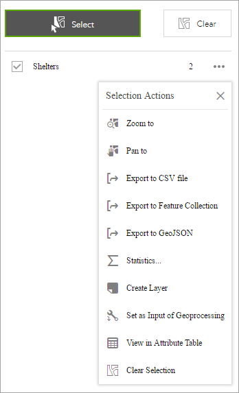
The Select widget enables you to interactively select features on the map and take actions on the selected features. The selected features can be passed on to other widgets as input, such as the Geoprocessing widget, Attribute Table widget, and Directions widget. The selection actions include the following:
- Zoom to—The default.
- Pan to—The default. Pan the map to selected features.
- Flash—The default. Make selected features flash.
- Export to CSV file—Export selected features to a .csv file.
- Export to Feature Collection—Export selected features to a features.json file.
- Export to GeoJSON—Export selected features to a features.geojson file.
- Save to My Content—Save selected features including a single feature as Feature Collection items to My Content in the contents page in ArcGIS Online or ArcGIS Enterprise.
- Add a Marker—Add a marker on a point feature.
- Show Pop-up—Not available for a set of features.
- Show Related Records—Show when the features have related records.
- Statistics—Not available for a single feature. It only summarizes the field with numeric type.
- Create Layer—Create a layer from a single feature or selected features.
- View in Attribute Table—Requires the Attribute Table widget configured to show the selected layer.
- Edit—Requires the Edit widget configured to edit the selected layer.
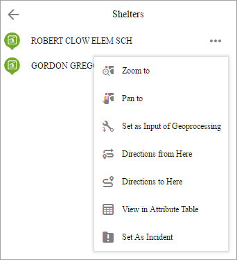
- Set as Incident—Requires the Incident Analysis widget and a single feature.
- Set as Input of Geoprocessing—Requires the Geoprocessing widget to configure the geoprocessing service accordingly based on the selected layer.
- Directions to here—Requires the Directions widget and a single point feature.
- Directions from here—Requires the Directions widget and a single point feature.
- Clear selection—The default. Clear the selection set.
Caution:
Some of the actions above may not be available, depending on a single feature or a set of features and widgets configured in the app.
The Select widget is an example of how the widgets communicate with each other.
Configure the Select widget
This widget can be set to open automatically when
an app starts. Hover over the widget and click the Do not open this widget when
the app starts button  to change the setting to Open this widget automatically when the app starts. (For widgets that you need to add to the app first, you can turn on this option after configuring the widget.)
- Hover over the widget and click the Configure this widget button
 to open the configuration window.
Note:
If you need to add the widget to the app first, click a widget placeholder on the Widget tab. In the Choose Widget window that opens, select the widget and click OK.
- Optionally, click change widget icon and replace it with your own image.
A file explorer window appears, allowing you to select a local image file to use as the widget icon.
- Choose a tool by clicking one of the buttons or multiple tools by pressing the Ctrl key while clicking buttons. The following selection tools are available. If multiple tools are chosen including Select By Rectangle, it becomes the default tool when using the widget.
- Select By Point
- Select By Line
- Select By Rectangle
- Select By Circle
- Select By Polygon
- Select By Lasso
- From the Set the selection color menu, choose the color to highlight the selected features.
- There are two options for Interactive selection mode. You can select features that are totally or partially within the rectangle or select features that are completely within the rectangle.
- Optionally, enable the select button by default.
- Check Allow to export selected features if you want to allow users to export the selected features to a .csv file, Feature Collection, or GeoJSON file, or to the My Content tab of the contents page as feature collection items in ArcGIS Online or ArcGIS Enterprise.
- Optionally, allow selecting layers that are generated at run time.
- Check a layer box to choose which layers are available to select in the map.
Use the Select widget
Complete the following steps to use the Select widget:
- Click the Select widget button to open it.
- Choose the layer or layers you want by checking the box next to the layers.
You can also make all layers selectable or not selectable, or turn on and off layer select ability by clicking the button in the upper right corner of the panel, inline with Layer.
- Hover over the Select button. You can choose Select By Rectangle with the following actions:
- Drag the pointer on the map to create a new selection.
- Press the Shift key while dragging the pointer on the map to add selected features to the selection.
- Press the Ctrl key while dragging the pointer on the map to remove selected features from the selection.
- Click Select and draw on the map to select features. If more than one selection tool is configured, use the Select button drop down arrow to choose a selection tool.
The number of selected features displays next to the layer.
- Click the more options button to open the Selection Actions menu.

- Click one of the actions, for example, Statistics. Choose the field for which you want to see the statistics.
- Click Create Layer to create a graphic layer on the map. You can turn it on and off in the Layer List widget.
- Click Export to CSV file if you checked the Allow to export selected features option during the configuration. A .csv file is generated locally for the feature set.
Caution:
If Export to GeoJSON is selected, you may notice that the GeoJSON file does not contain spatial reference information. This is by design. The geometries have been automatically projected to WKID 4326 during the exporting process.
- Optionally, click the rest of the actions.
- Click the close button on the main panel to close the drop-down menu.
- Alternatively, click the number to display the list of features. Click the more options button next to the feature to open the selection actions drop-down menu.

- Click one of the actions, for example, Directions from Here. The feature location becomes one of the destinations in the Directions widget.
- Click Set As Incident. The feature location becomes the incident with a 10-mile buffer around it.
- Optionally, click the rest of the actions.
- Click the Back button
 to return to the main panel.
 - Click Clear to clear all the selections.