 Hide Table of Contents
 Analysis
 Dynamic Layers
 Editing
 Feature Layers
 Feature Table
 Graphics
 Map
Map
 Mobile
 Online and Portal
 Popups and Info Windows
 Query and Select
 Renderers, Symbols, Visualization
 Search

FeatureTable - Custom Menu Items
View live sample
Description
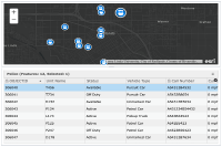
This sample demonstrates how FeatureTable displays attributes of a FeatureLayer.
- Shows how to edit existing attributes in the table by setting FeatureTable.editable property to true.
- Shows how to add custom functional menu items to 'Options' dropdown menu using menuFunctions property.
- How FeatureTable.refresh() method re-fetches features from the layer once the layer's definitionExpression is set.
- How to change labels and editability of a field using fieldOptions property.
- How to set interactions between the map and the table by:
- setting FeatureTable.syncSelection property to true to enable selection from the table to the map.
- implementing the layer's click logic to enable selection from the map to the table.
Code
<!DOCTYPE html>
<html>

<head>
  <meta http-equiv="Content-Type" content="text/html; charset=utf-8">
  <meta name="viewport" content="initial-scale=1, maximum-scale=1,user-scalable=no"/>
  <title>FeatureTable - Custom Menu Items</title>
  <link rel="stylesheet" href="https://js.arcgis.com/3.46/dijit/themes/claro/claro.css">
  <link rel="stylesheet" href="https://js.arcgis.com/3.46/esri/css/esri.css">
  <script src="https://js.arcgis.com/3.46/"></script>

  <style>
    html, body, #map {
      width: 100%;
      height: 100%;
      margin: 0;
      padding: 0;
    }
  </style>

  <script>
    require([
      "esri/layers/FeatureLayer",
      "esri/dijit/FeatureTable",
      "esri/geometry/Extent",
      "esri/graphicsUtils",
      "esri/tasks/query",
      "esri/symbols/PictureMarkerSymbol",
      "esri/map",
      "dojo/dom",
      "dojo/parser",
      "dojo/ready",
      "dojo/on",
      "dijit/layout/ContentPane",
      "dijit/layout/BorderContainer"
    ], function (
      FeatureLayer, FeatureTable, Extent, graphicsUtils, Query, PictureMarkerSymbol, Map,
      dom, parser, ready, on, ContentPane, BorderContainer
    ) {

      parser.parse();

      ready(function(){
        var map = new Map("map",{
          basemap: "dark-gray-vector",
          extent: new Extent({xmax: -13035353.854156237, xmin: -13053431.211345658,
            ymax: 4038351.1313028745, ymin: 4034089.766975982,
            "spatialReference":{"wkid":102100,"latestWkid":3857}
          })
        });

        //Load a FeatureTable to the application once map loads
        map.on("load", loadTable);

        function loadTable(){

          // editable FeatureLayer
          var myFeatureLayer = new FeatureLayer("https://sampleserver6.arcgisonline.com/arcgis/rest/services/RedlandsEmergencyVehicles/FeatureServer/1", {
            mode: FeatureLayer.MODE_ONDEMAND,
            outFields: ["*"],
            visible: true,
            id: "fLayer2"
          });

          // set a selection symbol for the featurelayer
          var selectionSymbol = new PictureMarkerSymbol("https://sampleserver6.arcgisonline.com/arcgis/rest/services/RedlandsEmergencyVehicles/FeatureServer/1/images/3540cfc7a09a7bd66f9b7b2114d24eee", 48 ,48);

          myFeatureLayer.setSelectionSymbol(selectionSymbol);

          // listen to featurelayer click event to handle selection
          // from layer to the table.
          // when user clicks on a feature on the map, the corresponding
          // record will be selected in the table.
          myFeatureLayer.on("click", function(evt) {
            var idProperty = myFeatureLayer.objectIdField,
              feature,
              featureId,
              query;

            if (evt.graphic && evt.graphic.attributes && evt.graphic.attributes[idProperty]) {
              feature = evt.graphic,
              featureId = feature.attributes[idProperty];

              query = new Query();
              query.returnGeometry = false;
              query.objectIds = [featureId];
              query.where = "1=1";

              myFeatureLayer.selectFeatures(query, FeatureLayer.SELECTION_NEW);
            }
          });

          // Redlands police vehicle locations layer
          // this layer is an editable layer
          map.addLayer(myFeatureLayer);

          //create new FeatureTable and set its properties
          var myFeatureTable = new FeatureTable({
            featureLayer : myFeatureLayer,
            map : map,
            editable: true,
            syncSelection: true,
            dateOptions: {
              datePattern: 'M/d/y',
              timeEnabled: true,
              timePattern: 'H:mm',
            },
            // use fieldInfos object to change field's label (column header),
            // change the editability of the field, and to format how field values are displayed
            // you will not be able to edit callnumber field in this example.
            fieldInfos: [
              {
                name: 'callnumber',
                alias: 'Call Number',
                editable: false //disable editing on this field
              },
              {
                name: 'speed',
                alias: 'Current Speed',
                format: {
                  template: "${value} mph" //add mph at the of the value
                }
              },
              {
                name: 'type',
                alias: 'Vehicle Type'
              },
              {
                name: 'unitname',
                alias: 'Unit Name'
              }
            ],
            // add custom menu functions to the 'Options' drop-down Menu
             menuFunctions: [
            {
              label: "Filter Available Emergency Vehicles",
              callback: function(evt){
                console.log(" -- evt: ", evt);
                // set definition expression on the layer
                // show only available emergency vehicles
                myFeatureLayer.setDefinitionExpression("status = 0");

                // call FeatureTable.refresh() method to re-fetch features
                // from the layer. Table will only show records that meet
                // layer's definition expression creteria.
                myFeatureTable.refresh();
              }
            },{
              label: "Show All Emergency Vehicles",
              callback: function(evt){
                console.log(" -- evt: ", evt);
                myFeatureLayer.setDefinitionExpression("1=1");
                myFeatureTable.refresh();
              }
            }]
          }, 'myTableNode');

          myFeatureTable.startup();

          // listen to refresh event
          myFeatureTable.on("refresh", function(evt){
            console.log("refresh event - ", evt);
          });
        }
      });
    });
  </script>
</head>
<body class="claro esri">
  <div data-dojo-type="dijit/layout/BorderContainer" data-dojo-props="design:'headline'" style="width:100%; height:100%;">
    <div data-dojo-type="dijit/layout/ContentPane" data-dojo-props="region:'center', splitter:true" style="height:50%">
      <div id="map"></div>
    </div>
    <div id="bot" data-dojo-type="dijit/layout/ContentPane" data-dojo-props="region:'bottom', splitter:true" style="height:50%;">
      <div id="myTableNode"></div>
    </div>
  </div>
</body>
</html>