 Hide Table of Contents
 Analysis
 Dynamic Layers
 Editing
 Feature Layers
 Feature Table
 Graphics
 Map
Map
 Mobile
 Online and Portal
 Popups and Info Windows
 Query and Select
 Renderers, Symbols, Visualization
 Search

BlendRenderer - Lawrence, KS by age and population size
Explore in the sandbox
Open in CodePen
View live sample
Description
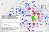
This sample focuses on Lawrence, KS, where it displays age concentrations with a BlendRenderer. In addition, it also displays the total population in each block using size. The BlendRenderer uses green to indicate the under 19 age group, red is 20-29, whereas blue represents 30 years and above. The more opaque the color, the higher the concentration for that age group. Also, more densely populated blocks will display with a larger symbol. More information on working with the BlendRenderer can be found here. Whereas information on how the graduated symbols were created can be found here.Code
<!DOCTYPE html>
<html>
  <head>
  <meta http-equiv="Content-Type" content="text/html; charset=utf-8">
  <meta name="viewport" content="initial-scale=1, maximum-scale=1,user-scalable=no" />
  <title>Lawrence, KS by age and size</title>
  <link rel="stylesheet" href="https://js.arcgis.com/3.46/dijit/themes/claro/claro.css">
  <link rel="stylesheet" href="https://js.arcgis.com/3.46/esri/css/esri.css">
  <style>
    html, body, #map {
      height: 100%;
      margin: 0;
    }

    #meta {
      position: absolute;
      left: 20px;
      bottom: 20px;
      width: 20em;
      height: 19em;
      z-index: 40;
      background: #ffffff;
      color: #777777;
      padding: 5px;
      border: 2px solid #666666;
      border-radius: 5px;
      font-family: arial;
      font-size: 0.9em;
    }

    #meta h3 {
      color: #666666;
      font-size: 1.1em;
      padding: 0px;
      margin: 0px;
      display: inline-block;
    }
  </style>
  <script src="https://js.arcgis.com/3.46/"></script>
  <script>
    require([
      "dojo/_base/array", "esri/Color", "esri/dijit/PopupTemplate", "esri/layers/ArcGISTiledMapServiceLayer", "esri/layers/FeatureLayer",
      "esri/map", "esri/renderers/BlendRenderer", "esri/symbols/SimpleFillSymbol",
      "esri/symbols/SimpleLineSymbol", "esri/symbols/SimpleMarkerSymbol", "dojo/domReady!"
    ], function (array, Color, PopupTemplate, ArcGISTiledMapServiceLayer, FeatureLayer, Map, BlendRenderer, SimpleFillSymbol, SimpleLineSymbol,
      SimpleMarkerSymbol){

      map = new Map("map", {
        basemap: "gray-vector",
        center: [-95.28, 38.959],
        zoom: 12
      });

      var layerUrl = "https://services.arcgis.com/V6ZHFr6zdgNZuVG0/arcgis/rest/services/Lawrence_KS_Demographic_Info/FeatureServer/0";

      //Set the blendRenderer's parameters
      var blendRendererOptions = {
        //blendMode:"color" //By default, it uses "source-over", uncomment to display different mode
        //See: http://developer.mozilla.org/en-US/docs/Web/API/CanvasRenderingContext2D/globalCompositeOperation
        symbol: new SimpleMarkerSymbol().setOutline(new SimpleLineSymbol().setWidth(0)),
        fields: [
          {
            field: "TotalPop2015_above30", //.65 to .26
            color: new Color("#0000e6") //blue
          }, {
            field: "POP2015_20to30", //.44 to .1
            color: new Color("#e60000") //red
          }, {
            field: "PopUnder18_2015", //.3 to .11
            color: new Color("#00e600") //green
          }
        ],
        opacityStops: [
          {
            value: .1,
            opacity: 0
          },
          {
            value: .65,
            opacity: .7
          }
        ],
        normalizationField: "TOTPOP_CY"
      };
      renderer = new BlendRenderer(blendRendererOptions);

      //set background fill symbol to show census block outlines
      renderer.backgroundFillSymbol = new SimpleFillSymbol().setColor(null).setOutline(new SimpleLineSymbol().setWidth(1).setColor(new Color([
        200, 200, 200
      ])));

      //size the markers by the total households
      renderer.setVisualVariables([
        {
          type: "sizeInfo",
          field: "TOTPOP_CY",
          minSize: 5,
          maxSize: 50,
          minDataValue: 50,
          maxDataValue: 1000
        }
      ]);

      //generate popup definition
      var template = new PopupTemplate({
        "fieldInfos": [
          {
            "fieldName": "POP2015_20to30",
            "label": "Population age 20 to 29",
            "visible": true,
            "format": {
              "places": 0,
              "digitSeparator": true
            }
          }, {
            "fieldName": "TotalPop2015_above30",
            "label": "Population age 30 and above",
            "visible": true,
            "format": {
              "places": 0,
              "digitSeparator": true
            }
          }, {
            "fieldName": "PopUnder18_2015",
            "label": "Population age 19 and under",
            "visible": true,
            "format": {
              "places": 0,
              "digitSeparator": true
            }
          }, {
            "fieldName": "TOTPOP_CY",
            "label": "Total Population",
            "visible": true,
            "format": {
              "places": 0,
              "digitSeparator": true
            }
          }
        ]
      });

      layer = new FeatureLayer(layerUrl, {
        outFields: ["TOTPOP_CY", "PopUnder18_2015", "TotalPop2015_above30", "POP2015_20to30"],
        opacity: 1,
        infoTemplate: template
      });

      layer.setRenderer(renderer);
      map.addLayer(layer);

    });
     </script>
  </head>
  <body class="claro">
    <div data-dojo-type="dijit/layout/BorderContainer" data-dojo-props="design:'headline',gutters:false" style="width: 100%; height: 100%; margin: 0;">
      <div id="map" data-dojo-type="dijit/layout/ContentPane" data-dojo-props="region:'center'">
         <div id="meta">
            <h3>Lawrence, Kansas age groups displayed using a BlendRenderer in addition to total population by size</h3>
            <br>
            <br>This sample focuses on Lawrence, KS, where it displays age concentrations with a BlendRenderer. In addition, it also displays the total population in each block using size.
            <ul>
               <li>Red: 20-29</li>
               <li>Blue: 30 and above</li>
               <li>Green: Under 19</li>
            </ul>
            The more opaque the color, the higher the concentration for that age group. In addition, the larger the symbol, the higher the population density for that block.
         </div>
      </div>
    </div>
  </body>
</html>