 Hide Table of Contents
 Analysis
 Dynamic Layers
 Editing
 Feature Layers
 Feature Table
 Graphics
 Map
Map
 Mobile
 Online and Portal
 Popups and Info Windows
 Query and Select
 Renderers, Symbols, Visualization
 Search

Smart Mapping - Render class breaks with color
Explore in the sandbox
Open in CodePen
View live sample
Description
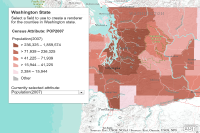
This sample is similar to the Generate Renderer sample but uses Smart Mapping functionality introduced at version 3.13. Instead of calling the generateRendererTask to generate a class breaks renderer, it uses the esri/renderers/smartMapping module's createClassedColorRenderer helper method. In this sample, the parameters passed in are the layer, field to classify, basemap, and the classification method used to generate the breaks.Code
<!DOCTYPE html>
<html>

<head>
   <meta http-equiv="Content-Type" content="text/html; charset=utf-8">
   <meta name="viewport" content="initial-scale=1, maximum-scale=1,user-scalable=no" />
   <title>Generate classed color breaks renderer</title>
   <link rel="stylesheet" href="https://js.arcgis.com/3.46/dijit/themes/tundra/tundra.css">
   <link rel="stylesheet" href="https://js.arcgis.com/3.46/esri/css/esri.css">
   <style>
      html,
      body {
         height: 100%;
         width: 100%;
         margin: 0;
         padding: 0;
      }
      #map {
         margin: 0;
         padding: 0;
      }
      #feedback {
         position: absolute;
         height: 410px;
         font-family: arial;
         margin: 5px;
         padding: 10px;
         z-index: 40;
         background: #fff;
         color: #444;
         width: 300px;
         left: 30px;
         top: 30px;
         box-shadow: 0 0 5px #888;
      }

      #legendWrapper {
         padding: 20px 0 0 0;
      }
      #note {
         font-size: 80%;
         font-weight: 700;
         padding: 0 0 10px 0;
      }
      h3 {
         margin: 0 0 5px 0;
         border-bottom: 1px solid #444;
      }
   </style>

   <script src="https://js.arcgis.com/3.46/"></script>
   <script>
      //global vars
      var layer, legend;

      require([

        "esri/map",
        "esri/dijit/PopupTemplate",
        "esri/layers/FeatureLayer",
        "esri/dijit/Legend",
        "esri/renderers/smartMapping",

        "dojo/_base/array",
        "dojo/dom",
        "dojo/dom-construct",
        "dojo/data/ItemFileReadStore",
        "dijit/form/FilteringSelect",
        "dojo/parser",

        "dijit/layout/BorderContainer",
        "dijit/layout/ContentPane",

        "dojo/domReady!"

      ], function (
         Map,
         PopupTemplate,
         FeatureLayer,
         Legend,
         smartMapping,

         array,
         dom,
         domConstruct,
         ItemFileReadStore,
         FilteringSelect,
         parser

      ) {

         parser.parse();

         var mapOptions = {
            basemap: "terrain",
            center: [-123.113, 47.035],
            zoom: 7,
            slider: false
         };

         var map = new Map("map", mapOptions);
         var fieldName = "POP2007";

         // the counties map service uses the actual field name as the field alias
        // set up an object to use as a lookup table to work with user friendly field names

         var fields = {
            "POP2007": "Population(2007)",
            "POP07_SQMI": "Population/Square Mile(2007)",
            "WHITE": "White",
            "BLACK": "Black",
            "AMERI_ES": "Native Americans",
            "HISPANIC": "Hispanic",
            "ASIAN": "Asian",
            "HAWN_PI": "Native Hawaiian/Pacific Islander",
            "MULT_RACE": "Multiple Races",
            "OTHER": "Other"
         };
         var outFields = ["POP2007", "POP07_SQMI", "WHITE", "BLACK", "AMERI_ES", "ASIAN", "HAWN_PI", "OTHER", "MULT_RACE", "HISPANIC", "STATE_NAME", "NAME"];

         //create popup
          var popupTemplate = new PopupTemplate({
            title: "{NAME} County",
            fieldInfos: [{
               "fieldName": fieldName,
               "label": fields[fieldName],
               "visible": true,
               "format": {
                  places: 0,
                  digitSeparator: true
               }
          }],
            showAttachments: true
         });

         layer = new FeatureLayer("//sampleserver6.arcgisonline.com/arcgis/rest/services/Census/MapServer/2", {
            "id": "Washington",
            "infoTemplate": popupTemplate,
            "mode": FeatureLayer.MODE_SNAPSHOT,
            "outFields": outFields,
            "opacity": 0.8
         });

         //only working with Washington state
         layer.setDefinitionExpression("STATE_NAME='Washington'");
         map.addLayer(layer);

         layer.on("load", function () {
             createRenderer(fieldName);
         });

         function createRenderer(field) {
            //smart mapping functionality begins
            smartMapping.createClassedColorRenderer({
               layer: layer,
               field: field,
               basemap: map.getBasemap(),
               classificationMethod: "quantile"
            }).then(function (response) {
               layer.setRenderer(response.renderer);
               layer.redraw();
               createLegend(map, layer, field);
            });
         }

         //this function gets called when fields are selected to render
         function updateAttribute(ch) {
             map.infoWindow.hide();

          var popupTemplateUpdated = new PopupTemplate({
            title: "{NAME} County",
            fieldInfos: [{
              "fieldName": ch,
              "label": fields[ch],
              "visible": true,
              "format": { places: 0, digitSeparator: true }
            }],
            showAttachments: true
          });
            layer.setInfoTemplate(popupTemplateUpdated);
            createRenderer(ch);
            layer.redraw();
            createLegend(map, layer, ch);
         }

         //Create a legend
         function createLegend(map, layer, field) {
            //If applicable, destroy previous legend
            if (legend) {
               legend.destroy();
               domConstruct.destroy(dom.byId("legendDiv"));
            }

           // create a new div for the legend
            var legendDiv = domConstruct.create("div", {
               id: "legendDiv"
            }, dom.byId("legendWrapper"));

            legend = new Legend({
               map: map,
               layerInfos: [{
                  layer: layer,
                  title: "Census Attribute: " + field
            }]
            }, legendDiv);
            legend.startup();
         }

         // create a store and a filtering select for the county layer's fields
         var fieldNames, fieldStore, fieldSelect;
         fieldNames = {
            "identifier": "value",
            "label": "name",
            "items": []
         };
         array.forEach(outFields, function (f) {
            if (array.indexOf(f.split("_"), "NAME") == -1) { // exclude attrs that contain "NAME"
               fieldNames.items.push({
                  "name": fields[f],
                  "value": f
               });
            }
         });

         fieldStore = new ItemFileReadStore({
            data: fieldNames
         });
         fieldSelect = new FilteringSelect({
            displayedValue: fieldNames.items[0].name,
            value: fieldNames.items[0].value,
            name: "fieldsFS",
            required: false,
            store: fieldStore,
            searchAttr: "name",
            style: {
               "width": "290px",
               "fontSize": "12pt",
               "color": "#444"
            }
         }, domConstruct.create("div", null, dom.byId("fieldWrapper")));
         fieldSelect.on("change", updateAttribute);

      });
   </script>
</head>

<body class="tundra">
   <div data-dojo-type="dijit.layout.BorderContainer" data-dojo-props="design:'headline',gutters:false" style="width: 100%; height: 100%; margin: 0;">
      <div id="map" data-dojo-type="dijit.layout.ContentPane" data-dojo-props="region:'center'">
         <div id="feedback">
            <h3>Washington State</h3>
            <div id="info">
             Select a field to use to create a renderer for the counties in Washington state.
            </div>
            <div id="legendWrapper"></div>
            <div id="fieldWrapper">
               Currently selected attribute:
            </div>
         </div>
      </div>
   </div>
</body>

</html>