 Hide Table of Contents
 Analysis
 Dynamic Layers
 Editing
 Feature Layers
 Feature Table
 Graphics
 Map
Map
 Mobile
 Online and Portal
 Popups and Info Windows
 Query and Select
 Renderers, Symbols, Visualization
 Search

BlendRenderer - Minority demographics
Explore in the sandbox
Open in CodePen
View live sample
Description
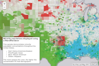
This sample demonstrates minority population concentrations throughout the United States. Red indicating Native American/Alaskan, green is Hispanic, blue represents African American, and pink/purple displays Asian concentrations. The more opaque the color, the higher the concentration for that demographic. More information on working with the BlendRenderer can be found here.Code
<!DOCTYPE html>
<html>
  <head>
  <meta http-equiv="Content-Type" content="text/html; charset=utf-8">
  <meta name="viewport" content="initial-scale=1, maximum-scale=1,user-scalable=no" />
  <title>BlendRenderer: United States minority population</title>
  <link rel="stylesheet" href="https://js.arcgis.com/3.46/dijit/themes/claro/claro.css">
  <link rel="stylesheet" href="https://js.arcgis.com/3.46/esri/css/esri.css">
  <style>
    html, body, #map {
      height: 100%;
      margin: 0;
    }

    #meta {
      position: absolute;
      left: 20px;
      bottom: 20px;
      width: 20em;
      height: 16em;
      z-index: 40;
      background: #ffffff;
      color: #777777;
      padding: 5px;
      border: 2px solid #666666;
      border-radius: 5px;
      font-family: arial;
      font-size: 0.9em;
    }

    #meta h3 {
      color: #666666;
      font-size: 1.1em;
      padding: 0px;
      margin: 0px;
      display: inline-block;
    }
  </style>
  <script src="https://js.arcgis.com/3.46/"></script>
  <script>
    require([
      "dojo/_base/array", "esri/Color", "esri/dijit/PopupTemplate", "esri/layers/ArcGISTiledMapServiceLayer", "esri/layers/FeatureLayer",
      "esri/map", "esri/renderers/BlendRenderer",
      "esri/symbols/SimpleFillSymbol", "esri/symbols/SimpleLineSymbol", "dojo/domReady!"
    ], function (array, Color, PopupTemplate, ArcGISTiledMapServiceLayer, FeatureLayer, Map, BlendRenderer, SimpleFillSymbol, SimpleLineSymbol){

      var map = new Map("map", {
        center: [-100, 38],
        zoom: 5
      });

      var tileLayer = new ArcGISTiledMapServiceLayer("https://tiles.arcgis.com/tiles/nzS0F0zdNLvs7nc8/arcgis/rest/services/US_Counties_basemap/MapServer ");
      map.addLayer(tileLayer);

      var layerUrl ="https://services.arcgis.com/P3ePLMYs2RVChkJx/arcgis/rest/services/USA_Counties_Generalized/FeatureServer/0";

      //Create the PopupTemplate to be used to display demographic info
      var template = new PopupTemplate({
        "title": "{NAME} County, {STATE_NAME}",
        "fieldInfos": [
          {
            "fieldName": "POP2010",
            "label": "Population",
            "visible": true,
            "format": {
              "places": 0,
              "digitSeparator": true
            }
          }, {
            "fieldName": "POP10_SQMI",
            "label": "Density, per sq. mi.",
            "visible": true,
            "format": {
              "places": 0,
              "digitSeparator": true
            }
          }, {
            "fieldName": "WHITE",
            "label": "White",
            "visible": true,
            "format": {
              "places": 0,
              "digitSeparator": true
            }
          }, {
            "fieldName": "ASIAN",
            "label": "Asian",
            "visible": true,
            "format": {
              "places": 0,
              "digitSeparator": true
            }
          }, {
            "fieldName": "BLACK",
            "label": "African American",
            "visible": true,
            "format": {
              "places": 0,
              "digitSeparator": true
            }
          }, {
            "fieldName": "HISPANIC",
            "label": "Hispanic",
            "visible": true,
            "format": {
              "places": 0,
              "digitSeparator": true
            }
          }, {
            "fieldName": "AMERI_ES",
            "label": "Native American/Alaskan",
            "visible": true,
            "format": {
              "places": 0,
              "digitSeparator": true
            }
          }
        ]
      });

      //Set the blendRenderer's parameters
      var blendRendererOptions = {
        blendMode: "darken", //By default, it uses "source-over", uncomment to display different mode
        //See: http://developer.mozilla.org/en-US/docs/Web/API/CanvasRenderingContext2D/globalCompositeOperation
        symbol: new SimpleFillSymbol().setOutline(new SimpleLineSymbol().setWidth(0)),
        fields: [
          {
            field: "AMERI_ES",
            color: new Color([230, 0, 0])
          }, {
            field: "HISPANIC",
            color: new Color([56, 168, 0])
          }, {
            field: "BLACK",
            color: new Color([0, 169, 230])
          }, {
            field: "ASIAN",
            color: new Color([255, 0, 197])
          }
        ],
        opacityStops: [
          {
            value: 0,
            opacity: 0
          },
          {
            value: .2,
            opacity: .7
          }
        ],
        normalizationField: "POP2010"
      };

      renderer = new BlendRenderer(blendRendererOptions);

      layer = new FeatureLayer(layerUrl, {
        outFields: ["WHITE", "POP2010", "AMERI_ES", "HISPANIC", "BLACK", "ASIAN", "POP10_SQMI", "NAME", "STATE_NAME"],
        opacity: 1,
        infoTemplate: template
      });

      layer.setRenderer(renderer);
      map.addLayer(layer);

    });
  </script>
  </head>
  <body class="claro">
    <div data-dojo-type="dijit/layout/BorderContainer" data-dojo-props="design: 'headline',gutters:false" style="width: 100%; height: 100%; margin: 0;">
      <div id="map" data-dojo-type="dijit/layout/ContentPane" data-dojo-props="region: 'center'">
         <div id="meta">
            <h3>Minority populations displayed using a BlendRenderer</h3>
            <br>
            <br>This sample demonstrates minority population concentrations throughout the United States.
            <ul>
             <li>Red: Native American/Alaskan</li>
             <li>Pink/Purple: Asian</li>
             <li>Blue: African American</li>
             <li>Green: Hispanic</li>
            </ul>
            The more opaque the color, the higher the concentration for that demographic.
         </div>
      </div>
    </div>
  </body>
</html>