 Hide Table of Contents
 Analysis
 Dynamic Layers
 Editing
 Feature Layers
 Feature Table
 Graphics
 Map
Map
 Mobile
 Online and Portal
 Popups and Info Windows
 Query and Select
 Renderers, Symbols, Visualization
 Search

Explore in the sandbox
Open in CodePen
View live sample
Description
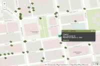
This sample demonstrates how to use the Popup class, introduced at version 2.3, as the info window for a feature layer. The Popup class is a custom info window that adds additional capabilities to the InfoWindow. The popup can replace the map's default info window and can display content like the results of a query or identify task or details about features in a feature layer. The Popup allows you to specify a set of features associated with the popup window using the Popup's setFeatures method. This method accepts an array of features or an array of deferreds that return features. In this snippet an array of deferreds that resolve to the selected features is associated with the map's info window.
This sample customizes the look of the popup applying a custom theme.
Code
<!DOCTYPE html>
<html>
<head>
  <meta http-equiv="Content-Type" content="text/html; charset=utf-8">

  <meta name="viewport" content="initial-scale=1, maximum-scale=1,user-scalable=no">
  <title>Popup</title>

  <link rel="stylesheet" href="https://js.arcgis.com/3.46/dijit/themes/claro/claro.css">
  <link rel="stylesheet" href="https://js.arcgis.com/3.46/esri/css/esri.css">
  <style>
    html, body, #map {
      padding: 0;
      margin: 0;
      height: 100%;
      width: 100%;
    }

    .esriScalebar {
      padding: 20px 20px;
    }

    .esriPopup.myTheme .titlePane,
    .dj_ie7 .esriPopup.myTheme .titlePane .title {
      background-color: #899752;
      color: #333333;
      font-weight: bold;
    }

    .esriPopup.myTheme .titlePane {
      border-bottom: 1px solid #121310;
    }

    .esriPopup.myTheme a {
      color: #d6e68a;
    }
    .esriPopup.myTheme .pointer.top{
      background-color:#899752;
    }
    .esriPopup.myTheme .outerPointer,  .esriPopup.myTheme .pointer.bottom{
      background-color:#424242;
    }

    .esriPopup.myTheme .contentPane,
    .esriPopup.myTheme .actionsPane {
      border-color: 1px solid #121310;
      background-color: #424242;
      color: #ffffff;
    }
  </style>

  <script src="https://js.arcgis.com/3.46/"></script>
  <script>
    var map;

    require([
      "esri/config",
      "esri/InfoTemplate",
      "esri/map",
      "esri/dijit/Popup",
      "esri/dijit/PopupTemplate",
      "esri/geometry/Extent",
      "esri/layers/FeatureLayer",
      "esri/layers/ArcGISTiledMapServiceLayer",
      "esri/symbols/SimpleFillSymbol",
      "esri/symbols/SimpleLineSymbol",
      "esri/tasks/GeometryService",
      "esri/tasks/query",
      "dojo/dom-construct",
      "dojo/dom-class",
      "dojo/parser",
      "esri/Color",
      "dojo/_base/lang",
      "dojo/date/locale",
      "dojo/domReady!"
    ],
      function (
        esriConfig, InfoTemplate, Map, Popup, PopupTemplate, Extent, FeatureLayer,
        ArcGISTiledMapServiceLayer, SimpleFillSymbol, SimpleLineSymbol,
        GeometryService, Query, domConstruct, domClass, parser, Color, lang, locale
      ) {

        parser.parse();

        var popup = new Popup({
          fillSymbol: new SimpleFillSymbol(SimpleFillSymbol.STYLE_SOLID,
            new SimpleLineSymbol(SimpleLineSymbol.STYLE_SOLID,
              new Color([255, 0, 0]), 2), new Color([255, 255, 0, 0.25]))
        }, domConstruct.create("div"));

        domClass.add(popup.domNode, "myTheme");

        map = new Map("map", {
          basemap: "topo-vector",
          center: [-122.402, 37.795],
          zoom: 18,
          infoWindow: popup
        });


        map.on("click", function (event) {
          var query = new Query();
          query.geometry = pointToExtent(map, event.mapPoint, 10);
          var deferred = featureLayer.selectFeatures(query,
            FeatureLayer.SELECTION_NEW);
          map.infoWindow.setFeatures([deferred]);
          map.infoWindow.show(event.mapPoint);
        });

        var incidentLayer = new ArcGISTiledMapServiceLayer ("https://services.arcgis.com/V6ZHFr6zdgNZuVG0/arcgis/rest/services/Street_Trees/MapServer");
        map.addLayer(incidentLayer);

        var template = new InfoTemplate();
        template.setContent(getTextContent);

        var featureLayer = new FeatureLayer("https://services.arcgis.com/V6ZHFr6zdgNZuVG0/arcgis/rest/services/SFStreetTreesRendered/FeatureServer/0",
          {
            mode: FeatureLayer.MODE_SELECTION,
            outFields: ["*"],
            infoTemplate: template
          });

        map.addLayer(featureLayer);

        function getTextContent (graphic) {
          var attributes = graphic.attributes;
          var scientificAndCommonName =
            attributes.qSpecies
            .replace('"', "")
            .split("::")
            .map(function (name) {
              return lang.trim(name);
            });
          var scientificName = scientificAndCommonName[0];
          var commonName = scientificAndCommonName[1];
          var speciesName;

          if (commonName) {
            speciesName = "<b>" + commonName + "</b><br/>" +
                          "<i>" + scientificName + "</i>";
          }
          else {
            speciesName = "<i>" + scientificName + "</i>";
          }

          return  speciesName + "<br>" +
                  attributes.qAddress + "<br/>" +
                  "Planted on " + formatDate(attributes.PlantDate);
        }

        function formatDate (value) {
          var inputDate = new Date(value);
          return locale.format(inputDate, {
            selector: 'date',
            datePattern: 'MMMM d, y'
          });
        }

        function pointToExtent (map, point, toleranceInPixel) {
          var pixelWidth = map.extent.getWidth() / map.width;
          var toleranceInMapCoords = toleranceInPixel * pixelWidth;
          return new Extent(point.x - toleranceInMapCoords,
                            point.y - toleranceInMapCoords,
                            point.x + toleranceInMapCoords,
                            point.y + toleranceInMapCoords,
                            map.spatialReference);
        }
      });
  </script>
</head>

<body class="claro">
  <div id="map"></div>
</body>

</html>