 Hide Table of Contents
 Analysis
 Dynamic Layers
 Editing
 Feature Layers
 Feature Table
 Graphics
 Map
Map
 Mobile
 Online and Portal
 Popups and Info Windows
 Query and Select
 Renderers, Symbols, Visualization
 Search

Query statistics
Explore in the sandbox
Open in CodePen
View live sample
Description
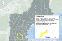
This sample shows how you can use a queryTask to get statistical information about data in a layer in a map service. Note that this functionality requires an ArcGIS Server 10.1 instance.The code to accomplish this uses the esri.tasks.StatisticDefinition class (new at ArcGIS API for JavaScript version 2.6) to get the maximum for a particlar field of a layer in a map service. Other statistics that can be returned by the map service are: minimum, sum, count, average and standard deviation
Code
<!DOCTYPE html>
<html>
  <head>
    <meta charset="utf-8">
    <meta name="viewport" content="initial-scale=1, maximum-scale=1,user-scalable=no">
    <title>Query statistics</title>
    <link rel="stylesheet" href="https://js.arcgis.com/3.46/dijit/themes/tundra/tundra.css">
    <link rel="stylesheet" href="https://js.arcgis.com/3.46/esri/css/esri.css">

    <style>
      html, body { height: 100%; width: 100%; margin: 0; padding: 0; }
      #map{ margin: 0; padding: 0; }
      #feedback {
        position: absolute;
        height: 330px;
        font-family: arial;
        margin: 5px;
        padding: 5px;
        z-index: 40;
        background: #fff;
        color: #444;
        width: 300px;
        right: 30px;
        bottom: 30px;
        -moz-box-shadow: 0 0 5px #888;
        -webkit-box-shadow: 0 0 5px #888;
        box-shadow: 0 0 5px #888;
      }
      #county {
        padding: 5px 0 0 0;
        font-weight: 700;
      }
      h3 { margin: 0 0 5px 0; border-bottom: 1px solid #444; }
    </style>

    <script>var dojoConfig = { parseOnLoad: true };</script>
    <script src="https://js.arcgis.com/3.46/"></script>
    <script>
      dojo.require("dijit.layout.BorderContainer");
      dojo.require("dijit.layout.ContentPane");
      dojo.require("dojox.widget.AnalogGauge");
      dojo.require("dojox.widget.gauge.AnalogArcIndicator");
      dojo.require("esri.map");
      dojo.require("esri.tasks.query");
      dojo.require("esri.layers.FeatureLayer");

      var app = {};
      app.abbrLookup = { "Maine": "ME", "Vermont": "VT", "New Hampshire": "NH", "Connecticut": "CT", "Massachusetts": "MA", "Rhode Island": "RI" };
      function init() {
        app.map = new esri.Map("map", {
          basemap: "oceans",
          center: [-70.324, 44.256],
          zoom: 7
        });

        var countiesUrl = "https://sampleserver6.arcgisonline.com/arcgis/rest/services/Census/MapServer/2";
        var stateList = "'Maine', 'New Hampshire', 'Vermont', 'Connecticut', 'Massachusetts', 'Rhode Island'";
        var newEnglandDef = dojo.string.substitute("STATE_NAME IN (${0})", [stateList]);
        var outFields = ["POP2007", "STATE_NAME", "NAME"];
        var outline = new esri.symbol.SimpleLineSymbol()
              .setColor(dojo.colorFromHex("#fff"));
        app.sym = new esri.symbol.SimpleFillSymbol()
              .setColor(new dojo.Color([52, 67, 83, 0.4]))
              .setOutline(outline);
        var renderer = new esri.renderer.SimpleRenderer(app.sym);

        var hColor = dojo.colorFromHex("#ff3");
        var hOutline = new esri.symbol.SimpleLineSymbol()
              .setColor(hColor).setWidth(4);
        app.highlight = new esri.symbol.SimpleFillSymbol()
              .setColor(new dojo.Color([0, 0, 0, 0]))
              .setOutline(hOutline);

        // use new 10.1 query statistic definition to find
        // the value for the most populous county in New England
        var popQueryTask = new esri.tasks.QueryTask(countiesUrl);
        var popQuery = new esri.tasks.Query();
        var statDef = new esri.tasks.StatisticDefinition();
        statDef.statisticType = "max";
        statDef.onStatisticField = "POP2007";
        statDef.outStatisticFieldName = "maxPop";

        popQuery.returnGeometry = false;
        popQuery.where = newEnglandDef;
        popQuery.outFields = outFields;
        popQuery.outStatistics = [ statDef ];
        popQueryTask.execute(popQuery, handlePopQuery);

        // create a feature layer for counties in New England
        app.neCounties = new esri.layers.FeatureLayer(countiesUrl, {
          "id": "NewEngland",
          "mode": esri.layers.FeatureLayer.MODE_ONDEMAND,
          "outFields": outFields
        });
        // set a definition expression so only counties in New England are shown
        app.neCounties.setDefinitionExpression(newEnglandDef);
        app.neCounties.setRenderer(renderer);

        dojo.connect(app.neCounties, "onMouseOver", showInfo);

        app.map.addLayer(app.neCounties);

        // create the gauge
        createGauge(dojo.byId("gauge"), 0);
      }

      function showInfo(evt) {
        app.map.graphics.clear();
        app.map.graphics.add(
          new esri.Graphic(
            evt.graphic.geometry,
            app.highlight
          )
        );
        updateGauge(evt.graphic);
      }

      function createGauge(gdiv, startValue) {
        var indicator = new dojox.widget.gauge.AnalogArcIndicator({
          interactionMode: "gauge",
          noChange: false,
          value: startValue,
          width: 20,
          offset: 65,
          color: "#ff3",
          title: "value",
          hideValue: true,
          duration: 100 // default is 1000
        });

        app.gauge = new dojox.widget.AnalogGauge({
          background: [200, 200, 200, 0.0],
          width: parseInt(gdiv.style.width, 10),
          height: parseInt(gdiv.style.height, 10),
          cx: parseInt(gdiv.style.width, 10) / 2,
          cy: parseInt(gdiv.style.height, 10) * 0.75,
          style: "position: absolute;",
          radius: parseInt(gdiv.style.width, 10) / 2,
          useTooltip: false,
          ranges: [{ low: 0, high: 100, color: "rgba(255,0,0,0)" }],
          majorTicks: { offset: 90, interval: 25, length: 3, color: 'black' },
          indicators: [ indicator ]

        }, dojo.create("div", null, gdiv));
        app.gauge.startup();

        // add percent label
        app.percentDiv = dojo.create("div",{
          "innerHTML": "0%",
          "style": {
            "position": "absolute",
            "bottom": app.gauge.height - app.gauge.cy + "px",
            "left": "-1000px",
            "font-family": "verdana",
            "font-size": "24px",
            "color":"#000"
          }
        });
        dojo.place(app.percentDiv, app.gauge.domNode);
        // put the percent label in the middle of the gauge
        var contentBox = dojo.contentBox(app.percentDiv);
        dojo.style(app.percentDiv, "left", app.gauge.cx + "px");
        dojo.style(app.percentDiv, "marginLeft", (-contentBox.w/2) + "px");
        if( app.gauge.cx ) {
          dojo.style(app.percentDiv, "marginBottom", (-contentBox.h/2) + "px");
        }
      }

      function updateGauge(g) {
        dojo.byId("county").innerHTML = "Highlighted: " + g.attributes.NAME +
          " County, " + app.abbrLookup[g.attributes.STATE_NAME] + "<br />" +
          "Population(2007): " + dojo.number.format(g.attributes.POP2007);
        var perc = parseInt((g.attributes.POP2007 / app.maxPop) * 100, 10);
        app.percentDiv.innerHTML = perc + "%";
        app.gauge.indicators[0].update(perc);
      }

      function handlePopQuery(result) {
        console.log('pop query...', result);
        app.maxPop = result.features[0].attributes.maxPop;
      }

      dojo.ready(init);
    </script>
  </head>

  <body class="tundra">
    <div data-dojo-type="dijit.layout.BorderContainer"
         data-dojo-props="design:'headline',gutters:false"
         style="width: 100%; height: 100%; margin: 0;">
      <div id="map"
           data-dojo-type="dijit.layout.ContentPane"
           data-dojo-props="region:'center'">

        <div id="feedback">
          <h3>County Info</h3>
          <div id="info">
            Mouse over to see how a particular county's population compares to the most populous county in New England (Middlesex, MA).
          </div>
          <div id="county">...county name here...</div>
          <div id="gauge" style="position:absolute; width: 290px; height: 230px;"></div>

        </div>
      </div>
    </div>
  </body>
</html>